
Hooge
| coat of arms | Germany map | |
|---|---|---|

|
Coordinates: 54 ° 34 ' N , 8 ° 33' E |
|
| Basic data | ||
| State : | Schleswig-Holstein | |
| Circle : | North Friesland | |
| Office : | Pellworm | |
| Height : | 5 m above sea level NHN | |
| Area : | 5.78 km 2 | |
| Residents: | 103 (Dec. 31, 2019) | |
| Population density : | 18 inhabitants per km 2 | |
| Postal code : | 25859 | |
| Area code : | 04849 | |
| License plate : | NF | |
| Community key : | 01 0 54 050 | |
| LOCODE : | DE HGE | |
| Address of the municipal administration: |
Uthlandestrasse 1 25849 Pellworm |
|
| Website : | ||
| Mayoress : | Katja Just (Hooge voter community) | |
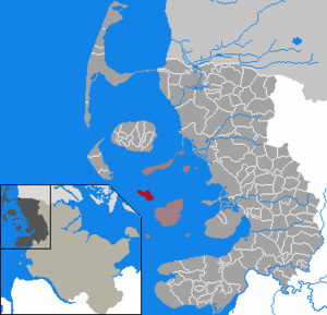
| Location of the municipality of Hallig Hooge in the district of North Friesland | ||
  |
||

Hooge ( Danish Hoge , Frisian Huuge ) is the second largest of the ten Halligen in the Schleswig-Holstein Wadden Sea . The municipality of Hallig Hooge (until December 31, 2007 municipality of Hooge ) includes the Hallig Hooge as well as the uninhabited Hallig Norderoog and belongs to the district of North Friesland .
geography
Unlike the other Halligen, Hooge is surrounded by a 1.20 meter high stone dike, so that it is protected from flooding by lighter storm surges . Nevertheless, the Hallig is affected by Landunter two to six times a year on average , with an upward trend. The inhabitants of the Hallig settle on ten terps . Hooge is surrounded by the Schleswig-Holstein Wadden Sea National Park , but not included in the National Park. However, it is located in the Schleswig-Holstein Wadden Sea and Halligen biosphere reserve .
geology
From a geological point of view, the foundations of the Hallig Hooge and the neighboring Hallig are only a good 10,000 years old. The rise in sea level by more than 30 meters at the end of the Ice Age caused the area of what is now North Friesland to sink into the sea up to the Geest line between Leck , Niebüll , Bredstedt and Husum . Around the birth of Christ, the prehistoric marshes and bog areas in this area were destroyed by floods during a rise in sea levels, the Dunkirk transgression . The former moors were largely covered by marsh soils deposited as silt .
Terps
The information relates to the last census of May 25, 1987, as population and households are not updated at the residential place level.
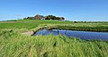
With the exception of the Volkertswarft and Mitteltritt, all Hooger terps are located on a tidal creek.
|
Living space no. 1 |
Terps | Topographic name |
population 2 | households 2 | NASA satellite image |
|---|---|---|---|---|---|
| 1 | Backenswarft | Group of houses | 31 | 10 |
 Hooge numbered with terps, bottom center Norderoog , top left Japsand, bottom left Norderoogsand (northern part) |
| 2 | Hanswarft | Group of houses | 47 | 16 | |
| 3 | Tent and playground | Youth camp | - | - | |
| 4th | Kirchwarft | Church, rectory | - | - | |
| 5 | Middle step | Group of houses | 10 | 5 | |
| 7th | Ockelützwarft | Group of houses, school | 14th | 6th | |
| 8th | Ockenswarft | Group of houses | 21st | 9 | |
| 9 | Volkertswarft | Youth camp | 1 | 1 | |
| 10 | Westerwarft | Group of houses | 7th | 3 | |
| 11 | Ipkenswarft | Group of houses | 3 | 2 | |
| 12 | Lorenzwarft | (Hotel) | - | - | |
| (without) | Pohnswarft | (no longer built on) | - | - | |
| Hooge | Hallig | 134 | 52 | ||
Hanswarft

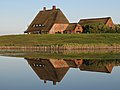
The Hanswarft is the main hangar of the Hallig. There you will find the mayor's office, the parish hall, the volunteer fire brigade , various shops, restaurants and museums (including a Hallig and local history museum), and the tourist office, in the basement of which there is a small hall where, for example, amateur theater is performed. In the storm surge cinema a documentary can land base are considered. The terp is one of the three stops on the carriage tours that day tourists are offered for a fee. The other two stops on the trips are the Kirchwarft and the Backenswarft.
The biggest tourist attraction is the Königspesel , a Frisian parlor from the 18th century that was damaged in a fire in 1995. The Danish King Friedrich VI once lived in this house . After a visit to the Hallig, which was then part of Danish territory, stayed overnight on the night of July 2nd to 3rd, 1825 because a storm surge made a departure impossible. It can be visited today and is the second museum in the terp.
The local history museum located on the Hanswarft was set up by the former postman from Hallig Hooge Hans von Holdt on the floor of his former cattle shed. It houses various objects from the Hallig as well as informative things about life on Hooge, which he collected after his retirement.
The Hooger Wadden Sea House of the Wadden Sea Protection Station is located on the Hanswarft in the New Bigger House. The nature conservation association has been active on Hooge since 1963. In his house he offers a natural history information center with many objects to see as well as sea water aquariums. School classes, members and sponsors have the opportunity to get to know the North Sea nature and nature conservation work on and around Hooge.
Backenswarft
The Backenswarft is the second largest terp on the Hallig Hooge with a dozen buildings that ring around the Fething and protect it from salt water. It houses the Friesenpesel , a restaurant decorated with historical Flemish tiles, as well as the paying office of a bank. The terp is located near the Hooger ferry terminal and is one of the three terps that are used for day-trippers on carriage tours.
Backenswarft
Kirchwarft

Ockelützwarft

Ockenswarft

Volkertswarft
View from the Backenswarft towards Kirchwarft
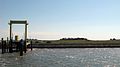
Ferry dock

Horses on a Fenne (Kirchwarft in the background)


history

The origin of the name "Hooge" is disputed. It may mean high (Hallig), because Hooge is slightly higher than the other Hallig.
Before 1362, Hooge was part of the Pellwormer Harde of Strand Island . It was separated from the beach by the Second Marcellus Flood . The church and dikes were destroyed. Since the 13th century, the North Frisians were subordinate to the Danish kings or the dukes of Schleswig . After the German-Danish War in 1864, Hallig Hooge belonged to Prussia from 1865 and to the German Empire from 1871 .
For a long time, one of the Hooger's industries was the salt works . In the 18th century Hallig Hooge was the richest of the Halligen. At that time, the island lived from seafaring, cattle and pasture farming and wool production. Since 1970 the Hallig has been supplied with drinking water from the mainland via a pipe.
Up until the 1950s, garbage disposal on Hallig Hooge did not play a role, as almost everything that was left over was recycled. This was mainly due to the almost purely agricultural orientation of the Hallig economy at that time. Since the 1950s, the garbage was buried in pits next to the terps, with one pit per year being sufficient. From the beginning of the 1970s, the garbage was collected in sacks and buried. Today the garbage is collected in containers and transported away.
population
The Hallig has decreased in size as well as in population over time. In 1593 there were 23 terps on Hooge, in 1758 there were 16. 200 years ago there were 10 terps, some of which were built with 20 houses, and 480 inhabitants. Before the flood of 1825 there were 100 houses and 393 inhabitants. 25 years later there were 70 houses and 250 residents. 100 years ago, 140 people lived on 9 built-up terps in 35 houses. In 2010 there were 110 residents, 83 of whom had their first place of residence, on December 31, 2011 only 84 residents.
politics
Community representation
In the 2018 local elections , the SPD and the Hooge electoral community each won three seats in the municipal council , the CDU one seat. In 2013 , the SPD won all seven seats in the municipal council.
coat of arms
Blazon : "In blue a downward facing golden anchor on silver rope that is wrapped around the anchor from top to bottom."
The golden anchor stands as a symbol for the seafaring, which was decisive for the life of the Hallig inhabitants. In addition, it also stands as a symbol of the hope with which the population overcame all threats. Blue and yellow are the colors of the state of Schleswig, to which the Hallig belongs.
Culture
Few, predominantly older Hallig residents speak the Hallig Frisian variant of North Frisian .
Women and girls traditionally wore traditional costumes . Around 1850, the traditional costume of the island of Föhr replaced the local costume. The Föhr costume was also not worn for a long time. Since the foundation of the “Hallig Hooge dance and costume group”, however, it has been shown to the public again. Every two years the "Hooger Trachtensommer" takes place on Hooge, where traditional costume wearers from the region meet.
Since 1998 the opening of the “Brent Goose Days” has taken place every year in April / May, when the Brent geese stop in the Wadden Sea on their journey north.
Infrastructure
The Hallig has a total of seven restaurants and snack bars as well as a Hallig museum.
Tourism provides a source of income for most residents . As in most Halligen, many people are employed by the State Office for Coastal Protection, National Park and Marine Protection . Hooge has the highest daily frequency of visitors of all Halligen, approx. 90,000 daily visitors per year. Apartments can be rented on all terps. In addition to the many holiday apartments, Hooge also offers some self-catering houses and youth homes for school classes or other groups. In 2008 the municipality of Hooge recorded 46,000 overnight stays with 532 guest beds. Estimates assume that the Hooger economy is now 70% dependent on tourism. Furthermore, guided mudflat hikes to the uninhabited Hallig Norderoog and to the Japsand sandbank are offered.
Currently there is still a full-time farmer on the Hallig. But even his cattle are not enough for extensive grazing. This is why some landowners take in so-called boarding cattle - cattle and sheep - from the mainland on the Hallig in the summer months. It also serves to maintain the landscape.
education
There is a primary and secondary school on Hooge, where four children were taught by a teacher in the 2016/17 school year. For the 2019/2020 school year, twelve students are expected.
traffic
In the summer months, numerous ferry and excursion boats from Langeneß , Amrum , Nordstrand , Föhr , Sylt and the mainland port Schlüttsiel dock . Scheduled ferry connections exist all year round with the car ferry of the Wyker Dampfschiffs-Reederei on the Schlüttsiel – Hooge – Langeneß line (in the summer half-year also to Amrum) and in the summer half-year additionally with the passenger ferry on the Nordstrand – Hooge – Amrum – Sylt line of the Adler-Schiff . A small motorboat from Pellworm also runs irregularly in summer .
Numerous day visitors use horse-drawn carriages or bicycles on Hooge. The single-lane roads are paved and can also be used by cars. However, guests are advised to leave their cars on the mainland.
St. John's Church

The St. John's Church is located on the Kirchwarft. Although the Hooger Church was not consecrated until 1637, the rear bench on the left side of the stalls bears the year 1624. In this year the Osterwohlder Church , which was destroyed in the great storm surge of 1634 , was consecrated. In addition to the stalls, the bricks of the church, the baptismal font and probably also the pulpit come from the destroyed Osterwohld church, a parish on the torn island of Strand .
Since Hooge had lost its wooden church after the sinking of Strand, it was assigned to the parish of Pellworm.
The church is surrounded by the cemetery, where the grave of the long-time Norderoog bird warden Jens Wand is located. In the cemetery there is a simple wooden cross, the " home for the homeless ". Unidentified beach bodies washed up on the beach were buried in its area.
It is noteworthy that the rectory next to the church is far larger than the church itself.
The only bell of the Hooger church hangs in the “ stack of bells ”, a wooden chair. The church services during the summer are often well attended and varied, as many Christian youth groups visit the Hallig every year. There are also occasional church services on Hooge that are held entirely in Low German ; the chorales are also sung in a Low German version.
The parish of Hooge is looked after by a pastor who lives on the Hallig. Services take place on all Sundays as well as the national holidays.
inventory

The pulpit of the church is decorated with scenes from the life of Jesus. Access to the pulpit is provided by the so-called "whale door", which dates from 1743 and shows a whale cow and her calf. The two choir windows are provided with colored motifs. The left window shows Peter in the storm, the right window shows Christ as the good shepherd. The ship hanging from the ceiling in the back of the church, a gift from the Hooger to the Danish King Friedrich VI , also has a special history . who had decreed that the ship should remain in the church.
A memorial plaque for the people and animals killed in the storm surge of 1825 hangs above the south door . Next to this door is a picture of Pastor Dr. Koch, who led a victorious battle against alcohol around 1850. The organ in the back of the church was built in the winter of 1959. Since the sea was frozen over by the time of delivery, it had to be approached by helicopter - dismantled.
The inventory of the church also includes a wooden cross with a body on the south wall and some paintings on the north wall, including a painting of Christ.
Others
- Hooge is often called the Queen of Halligen .
- A mailbox is set up on each of the Ockelützwarft, Hanswarft, Volkertswarft and Backenswarft.
- There is a telecommunications tower on the Ockenswarft, which supplies Hooge with telephone and Internet connections via a radio link to Pellworm .
- The sculptor Carl Schümann lived on Hooge.
literature
- Günther Schirrmacher: Hallig Hooge . 11th edition. Breklumer Buchhandlung und Verlag, Breklum 2004, ISBN 978-3-7793-1112-6 (first edition: 1993).
- Georg Quedens : The Halligen . 19th edition. Breklumer Buchhandlung und Verlag, Breklum 2004, ISBN 978-3-7793-1114-0 .
Web links
- Hallig Hooge tourist office
- Hand against bunk
- Pictures of the Hallig Hooge at kuestenforum.de
- Tide table for Hooge
- PDF file with a detailed map of the Hallig
- Map from 1880
Individual evidence
- ↑ North Statistics Office - Population of the municipalities in Schleswig-Holstein 4th quarter 2019 (XLSX file) (update based on the 2011 census) ( help on this ).
- ↑ Federal Statistical Office, area changes from 01.01. until December 31, 2008
- ↑ Germany rediscovered: d. Federal Republic of Germany in color vertical aerial photo . 2., through Ed. By Hase and Koehler, Mainz 1976, ISBN 978-3-7758-0839-2 ( dnb.de [accessed April 12, 2020]).
- ↑ Official population statistics as of December 31, 2010 (PDF file; 443 kB), accessed on August 14, 2011
- ^ Website of the municipality (PDF), accessed on August 9, 2018
- ^ SPD Schleswig-Holstein on local elections ( Memento from March 13, 2016 in the Internet Archive ) (PDF)
- ↑ Schleswig-Holstein's municipal coat of arms
- ↑ Hallig Hooge tourist office , accessed on September 14, 2012
- ↑ a b Hallig Hooge in numbers - Homepage of the municipality of Hooge
- ^ School website , accessed January 30, 2017
- ↑ Genevieve Wood: Who wants to teach 12 students in the middle of the Wadden Sea? Abendblatt.de of April 23, 2019, accessed on April 29, 2019
Achtrup | Ahrenshöft | Ahrenviöl | Ahrenviölfeld | Alkersum | Almdorf | Arlewatt | Aventoft | Bargum | Behrendorf | Bohmstedt | Bondelum | Bordelum | Borgsum | Bosbull | Braderup | Bramstedtlund | Bredstedt | Breklum | Dagebüll | Drage | Drelsdorf | Dunsum | Elisabeth-Sophien-Koog | Ellhöft | Emmelsbüll-Horsbüll | Narrow Sands | Fresendelf | Friedrich-Wilhelm-Lübke-Koog | Friedrichstadt | Galmsbüll | Garding | Garding, parish | Goldebek | Goldelund | Gröde | Grothusenkoog | Haselund | Hattstedt | Hattstedtermarsch | Högel | Spar | Hooge | Hörnum (Sylt) | Horstedt | Hude | Humptrup | Husum | Immenstedt | Joldelund | Kampen (Sylt) | Karlum | Katharinenheerd | Klanxbüll | Klixbull | Koldenbüttel | Kolkerheide | Kotzenbüll | Ladelund | Langeneß | Langenhorn | Leak | Lexgaard | List on Sylt | Löwenstedt | Lütjenholm | Midlum | Mildstedt | Fog | Neukirchen | Nieblum | Niebüll | Norddorf on Amrum | Norderfriedrichskoog | North beach | Norstedt | Ockholm | Oevenum | Oldenswort | Oldersbek | Olderup | Oldsum | Ostenfeld (Husum) | Oster-Ohrstedt | Osterhever | Pellworm | Poppenbüll | Ramstedt | Rantrum | Reußenköge | Risum-Lindholm | Rodenäs | Sankt Peter-Ording | Schwabstedt | Schwesing | Seeth | Simonsberg | Sollwitt | Sönnebüll | Sprakebull | Stadum | Stedesand | Struckum | South end | Süderhöft | Süderlügum | South March | Sylt | Tating | Tetenbull | Tinningstedt | Tönning | Tümlauer-Koog | Uelvesbüll | Uphusum | Utersum | Viöl | Vollerwiek | Vollstedt | World | Wenningstedt-Braderup (Sylt) | Wester-Ohrstedt | Westerhever | Westre | Winnert | Wipe | Witsum | Wittbek | Wittdün on Amrum | Joke word | Wobbenbüll | Wrixum | Wyk on Föhr

Islands in Denmark and Germany:
Amrum |
Fanø |
Foehr |
Koresand |
Langli |
Mandø |
Norderoogsand |
Pellworm |
Rømø |
Sylt |
Uthorn
Halligen:
Gröde |
Habel |
Hamburger Hallig |
Hooge |
Langeneß |
Norderoog |
Nordstrandischmoor |
Oland |
Süderoog |
South fall
High sands:
Japsand |
Jordsand |
Boy name sand |
Kniepsand |
Cormorant Island |
Süderoogsand