Süderoogsand
| Süderoogsand | ||
|---|---|---|
| NASA satellite image, with Hallig Süderoog at the top right | ||
| Waters | North Sea | |
| Geographical location | 54 ° 26 '24 " N , 8 ° 28' 41" E | |
|
|
||
| length | 7 km | |
| width | 4 km | |
| surface | 15 km² | |
| Map of the North Frisian Islands | ||
Süderoogsand ( North Frisian Saruug Söön ) is the largest and most southerly of the three North Frisian Outer Sands ( high sands ) in the Schleswig-Holstein Wadden Sea National Park , which are off the Halligen in the west. The Süderoogsand is located southwest of Süderoog and Pellworm and northwest of Westerhever in Eiderstedt . It is separated from Norderoogsand in the north by the Rummelloch and in the south from the Heverstromand is 7 km long in a north-south direction with a maximum width of 4 km. The area is around 15 km². The outer sand sometimes has small dunes in the west under favorable conditions, falls flat in the east and merges into the sandy mudflats without a visible border . Süderoogsand “migrates” up to 40 m a year to the east.
Beacon
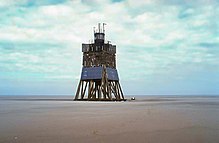
At the time of sailing, ships ran aground on Süderoogsand every year and were usually smashed by the surf within a few days or sank in the sand. Therefore, in 1867 the Prussian administration erected a 24 m high beacon made of tarred wooden beams with a spherical top mark . This construction was given a shelter for shipwrecked people. In 1891 the beacon, which was destroyed by a storm, was rebuilt 20 m further south. By relocating the outer sand, it was necessary to move the beacon several times. In 1940 the beacon was given a gas lantern instead of the top sign and thus became a lighthouse .
A new building took place in 1985. The wooden beacon and rescue beacon has a height of 19 m and a fire height of 18 m above MTW. It stands on the southern end of the sand at 54 ° 25 ′ 30 ″ N , 8 ° 28 ′ 44 ″ E and is equipped with a 24 V / 100 W halogen lamp that is operated by solar cells . The rescue, switchgear and power unit cabin as well as the lamp post are made of aluminum. The Tönning Waterways and Shipping Office is responsible for operation and maintenance . Another new building will be carried out in autumn 2017 to replace the existing beacon.
Peregrine falcons have been breeding in the beacon since 1995 . It was a pair that has resettled there since the species disappeared in Schleswig-Holstein. In 2010 three pairs of peregrine falcons brooded on Süderoogsand.
Wrecks
At the turn of the year 2012/13, three shipwrecks were cleared near the beacon. In addition to an unknown wooden ship from around 1700 and a steel ship, it was the Spanish barque Ulpiano, which was stranded on its maiden voyage on Christmas Eve 1870.
literature
- Uwe Muuß, Markus Petersen: The coasts of Schleswig-Holstein . Karl Wachholtz, Neumünster, ISBN 3-529-05301-5 .
- Karsten Hansen: The Ulpiano's Secret. Boyens, Heide 2011, ISBN 978-3-8042-1362-3 .
Web links
- Beacon on Süderoogsand on the side of the responsible WSA
- History and operation of the beacon on Süderoogsand at baken-net.de
- Photos from Süderoogsand at karstenhansen.de
Individual evidence
- ↑ The sea exposes the Ulpiano. shz.de from January 16, 2013, accessed on December 28, 2015
- ↑ a b History and operation of the beacon on Süderoogsand at baken-net.de , accessed on January 19, 2013
- ^ Report at nationalpark-wattenmeer.de , accessed on December 28, 2015
- ↑ Three shipwrecks exposed on the sandbank. Handelsblatt from January 16, 2013


