
Cormorant Island
| Cormorant Island | ||
|---|---|---|
 |
||
| Waters | German Bight , North Sea | |
| Geographical location | 54 ° 44 '40 " N , 8 ° 21' 28" E | |
|
||
 |
||


The Cormorant Island is a high sand in the Wadden Sea of the German Bight . It is about 3.5 kilometers away from the Schleswig-Holstein islands of Sylt , Föhr and Amrum . It was first recorded on nautical charts in 2000.
Surname
The cormorant island was probably named by participants in a survey trip.
geography
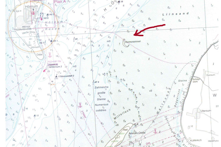
The Kormoraninsel is located east of Hörnum-Odde , west-northwest of Dunsum and north of Amrumer Odde . The surrounding sandbank is known as Liinsand . The roughly crescent-shaped, 500-meter-long high sand is used by seals and numerous sea birds. An approach is possible as part of a guided mudflat hike from Föhr and Amrum. The high sand, on the other hand, is separated from Hörnum-Odde by the 23 meters deep Hörnumtief .
history
The cormorant island grew after 2000 when sand was washed up. Sources of the sand - recognizable by the grain size - are mainly the sand pre-washings off Sylt and the sandbanks west of the Cormorant Island, including the Jungnamensand . Between 2016 and 2017 the high sand lost about half of its area.
Web links
- Nautical chart (excerpt with cormorant island and Liinsand)
- Malte Keller: On the way to the cormorant island in the Wadden Sea. frankfurt-live.com from April 3, 2018
Individual evidence
- ↑ a b c d Astrid Thomas-Niemann: A spring hike to the cormorant island. amrum-news.de from April 13, 2017
- ↑ Oliver Abraham: Journey: New Land Norderoogsand. Süddeutsche Zeitung of August 19, 2017, accessed on August 21, 2017
Islands in Denmark and Germany:
Amrum |
Fanø |
Foehr |
Koresand |
Langli |
Mandø |
Norderoogsand |
Pellworm |
Rømø |
Sylt |
Uthorn
Halligen:
Gröde |
Habel |
Hamburger Hallig |
Hooge |
Langeneß |
Norderoog |
Nordstrandischmoor |
Oland |
Süderoog |
South fall
High sands:
Japsand |
Jordsand |
Boy name sand |
Kniepsand |
Cormorant Island |
Süderoogsand