
Mandø
| Mandø | ||
|---|---|---|
 |
||
| Waters | German Bight , North Sea | |
| Archipelago | Danish Wadden Islands | |
| Geographical location | 55 ° 16 '50 " N , 8 ° 33' 10" E | |
|
||
| length | 3.2 km | |
| width | 2.6 km | |
| surface | 7.63 km² | |
| Highest elevation | 2 m | |
| Residents | 38 (January 1, 2020) 5 inhabitants / km² |
|
| main place | Mandø By | |
 |
||

Mandø is the only Danish tidal island . It is located on the west coast of Jutland . The 7.63 km² island lies between the two islands of Rømø and Fanø and is one of the Danish Wadden Sea Islands . The island is one of the smallest parish communities ( Dan. : Sogn ) Denmark ( Mando Sogn ) and belonged until 1970 Harde Ribe Herred in the former Ribe County , then to Ribe Municipality in extended Ribe County , with the municipal reform on 1 January 2007 in the Esbjerg municipality in the region South Denmark has risen.
history
After storm surges that flooded the island and destroyed the only place, the residents settled in the protection of a natural dune in the 17th century and regained their island through land reclamation measures in the following 200 years . Around 1890 the population reached its maximum with almost 300. Mandø was once the only Hallig in Denmark and has been protected by a sea dike since 1937 .
Infrastructure
Southwest of the island is the high sand Koresand . This can be reached at low tide by hiking through the mudflats or by tractor.
There is a small campsite, a few holiday homes and apartments and overnight accommodation in the local restaurant and the Mandøcenter. There is also an exhibition about the Wadden Sea.
traffic
You can reach Mandø by car via Låningsvej , a kind of dam that is not passable during high tide as it consists only of flat gravel and is secured by groynes . The gravel path is 55 cm above the mudflat and one passage takes about 20 minutes. In addition to the tides, the passability also depends on the prevailing wind - with strong westerly winds the period around the low water, in which the Låningsvej is passable, is significantly shorter.
Further south there is also the Ebbevej , but it is only passable for tractors with trailers for the transport of tourists. They are called "Mandø buses" and go to the island from Vester Vedsted .
The residents of Mandø reject the construction of a tidal dam because this measure would bring a large number of tourists to the island, but Mandø is too small for that.
natural reserve
In 2017, the Danish environmental foundation Den Danske Naturfond bought 127 hectares of land on Mandø in order to protect the migratory birds and the unique nature on the island. This means that 175 hectares of land are now under protection. The foundation is using 12 million Danish. Crowns on.
See also
photos

View of the open sea in the west of the island
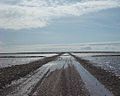
Låningsvej, with Mandø in the background

The Låningsvej

Koresand at low tide, Mandø in the background on the left

Ebbevej at high tide, from the mainland


Web links
Individual evidence
- ↑ Statistics banks -> Befolkning og valg -> BEF4: Folketal pr. January 1st demands på øer (Danish)
- ↑ Danmarks Statistics : Statistical Yearbook 2009 - Geography and climate, Table 3 Area and population. Regions and inhabited islands (English; PDF; 39 kB)
- ↑ website Mandoeturist.dk - Transport , Danish, accessed on January 16, 2018
- ↑ Den Danske Naturfond: Naturperle på Mandø bliver nu til virkelighed (Julie Søgaard), January 3, 2018 , in Danish, accessed on January 16, 2018

Islands in Denmark and Germany:
Amrum |
Fanø |
Foehr |
Koresand |
Langli |
Mandø |
Norderoogsand |
Pellworm |
Rømø |
Sylt |
Uthorn
Halligen:
Gröde |
Habel |
Hamburger Hallig |
Hooge |
Langeneß |
Norderoog |
Nordstrandischmoor |
Oland |
Süderoog |
South fall
High sands:
Japsand |
Jordsand |
Boy name sand |
Kniepsand |
Cormorant Island |
Süderoogsand