
Nordstrandischmoor
| Nordstrandischmoor | ||
|---|---|---|
 |
||
| Waters | German Bight , North Sea | |
| Archipelago | North Frisian Islands | |
| Geographical location | 54 ° 32 '59 " N , 8 ° 48' 44" E | |
|
||
| length | 2.6 km | |
| width | 800 m | |
| surface | 1.9 km² | |
| Highest elevation | (Neuwarft) 3 m |
|
| Residents | 18th (2010) 9.5 inhabitants / km² |
|
| main place | Neuwarft | |
 |
||

Nordstrandischmoor ( Danish Nordstrand Mor or Nordstrandmose , North Frisian Lätj Möör ; colloquially known as Lüttmoor within the regional population as in North Frisian ) is a Hallig off the North Frisian coast.
geography
The Hallig land area lies within the Schleswig-Holstein Wadden Sea and Halligen biosphere reserve . Nordstrandischmoor is surrounded by the Schleswig-Holstein Wadden Sea National Park , but is not part of it itself.
Administratively, Nordstrandischmoor belongs to the municipality of Nordstrand and forms one of the two districts of this municipality. The Hallig has an area of 1.9 km². It has its greatest extension approximately in a west-east direction. The coast is fortified by a shallow stone dike. In December 2010, 18 people lived on Nordstrandischmoor.
On the Hallig there are four terps , a primary and secondary school (with four students one of the smallest schools in Germany - as of 2017) and a restaurant. The four terps, from east to west:

|
||||
| Terps | Topographic name |
Population update June 30, 2005 |
||
|---|---|---|---|---|
| population | households | |||
| Neuwarft 1 | (Group of houses) | 14th | 2 | |
| Amalienwarft 2 | (School / church) | - | - | |
| Halberwegwarft | (House) | 1 | 1 | |
| Norderwarft | (House) | 7th | 1 | |
| Nordstrandischmoor | Hallig | 22nd | 4th | |
In the official residential directory, the entire Hallig Nordstrandischmoor is listed as residential area 38 within the municipality of Nordstrand. Unlike in the case of the Halligen Langeneß , Hooge and Gröde , which also each have more than one inhabited or built-up terp, the individual terps do not count as separate living spaces.
The connection to the mainland consists of the Halligbahn Lüttmoorsiel – Nordstrandischmoor , a field railway with a gauge of 600 mm, heading east to Beltringharder Koog . There is a jetty in the south of the Hallig. There is a small sailing harbor in the west. When the tide is low , Nordstrandischmoor can be reached on foot from the mainland through the tidal flats .
history
Nordstrandischmoor is the youngest Hallig. Along with the islands of Pellworm and Nordstrand , it is one of the fragments of the island of Strand , which sank in the Burchardi flood of 1634 . Before this storm surge, Nordstrandischmoor was an uninhabited raised bog that was used for cutting peat. During the flood, the high country became a place of refuge, where after the flood some families settled, who lived partly from the produce of the moor, partly from fishing and sheep breeding. At first they stayed with the last remaining church on Nordstrand in Odenbüll, before Nordstrandischmoor became its own parish in 1642 and Sebastian Heimreich became pastor here. His successor from 1652 was his brother, the chronicler Anton Heimreich , during whose tenure the first church was built in 1656.
Gradually the lands were repaired by adding marsh soil that surrounded the island. In 1717 there were already 20 apartments, of which on December 24, 1717 and the following day, 18 and the church were washed away by the floods of the Christmas flood , and 15 people died. In the following year, some houses were built again, some of which were destroyed again in 1720 . After the storm surge of February 3rd and 4th, 1825 , three of seven houses were left. The church - the fourth since 1656 - and the pastorate, which also housed the sexton , had suffered so much that they had to be demolished. The last clergyman was Johann Christoph Biernatzki , whose descriptions of the life of the Hallig residents were widely known at the time. Since then, Nordstrandischmoor no longer has its own church. Funerals in the still preserved cemetery took place until the beginning of the 20th century.
The area of the Hallig has decreased to about a third since 1634. This shrinkage was only stopped by the stone fortification in 1926. At the same time the lorry connection to the mainland was established.
traffic
The inhabitants of Nordstrandischmoors usually use the Lorenbahn to get to the mainland. Overnight guests are picked up there by cart. Day tourists are taken on excursion boats, such as the Adler V, from Strucklahnungshörn on Nordstrand to the pier on Nordstrandischmoor during high tide , and then usually spend a few hours on the Hallig.
photos

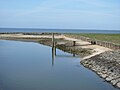
View from the mainland to the Hallig with its four terps and the Lorendamm

Amalienwarft with school house

Halligbahn Lüttmoorsiel-Nordstrandischmoor

Halligbahn Lüttmoorsiel-Nordstrandischmoor

Ship landing stage on Nordstrandischmoor
Beach

Coastal fortification
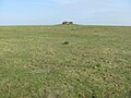
Norderwarft

Historic cemetery

The mailbox: emptying on Fridays, depending on the tide
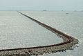
Dam for the Lorenbahn in high water


Others
There has been an island mating station for the Mellifera bee on Nordstrandischmoor since 2015 .
literature
- Fritz Karff: From the chronicle of the Hallig Nordstrandischmoor . Christians, Hamburg 1979, ISBN 3-7672-0616-1
- Georg Kullik: The Hallig Nordstrandischmoor . Christians, Hamburg 1995, ISBN 3-7672-1230-7
Web links
Individual evidence
- ↑ including: Henning Dehn-Nielsen: Sydslesvig på kryds og tværs , Lindhardt and Ringhof 2017
- ^ Information from the official administration on December 7, 2010
- ↑ Hallig Nordstrandischmoor at indigo-blau.de, accessed on April 13, 2018
- ↑ Zuchtgemeinschaft Dunkle Biene Nord: The island mooring point Nordstrandischmoor. On: inselbelegstelle-dunkle-biene.de , accessed on July 22, 2016

Islands in Denmark and Germany:
Amrum |
Fanø |
Foehr |
Koresand |
Langli |
Mandø |
Norderoogsand |
Pellworm |
Rømø |
Sylt |
Uthorn
Halligen:
Gröde |
Habel |
Hamburger Hallig |
Hooge |
Langeneß |
Norderoog |
Nordstrandischmoor |
Oland |
Süderoog |
South fall
High sands:
Japsand |
Jordsand |
Boy name sand |
Kniepsand |
Cormorant Island |
Süderoogsand