
Halligbahn Lüttmoorsiel – Nordstrandischmoor
| Lüttmoorsiel – Nordstrandischmoor | |||||||||||||||||||||||||||||||||||||||||||||||||
|---|---|---|---|---|---|---|---|---|---|---|---|---|---|---|---|---|---|---|---|---|---|---|---|---|---|---|---|---|---|---|---|---|---|---|---|---|---|---|---|---|---|---|---|---|---|---|---|---|---|
 | |||||||||||||||||||||||||||||||||||||||||||||||||
| Route number (DB) : | - | ||||||||||||||||||||||||||||||||||||||||||||||||
| Course book section (DB) : | - | ||||||||||||||||||||||||||||||||||||||||||||||||
| Route length: | 3.5 km | ||||||||||||||||||||||||||||||||||||||||||||||||
| Gauge : | 600 mm ( narrow gauge ) | ||||||||||||||||||||||||||||||||||||||||||||||||
|
|||||||||||||||||||||||||||||||||||||||||||||||||

The Lüttmoorsiel – Nordstrandischmoor construction line , also known as the Lorenbahn , is a Hallig railway opened in 1934 with a gauge of 600 mm through the North Frisian Wadden Sea from Beltringharder Koog to Hallig Nordstrandischmoor .
Legal status
The railway is a non-public railway facility owned by the State of Schleswig-Holstein , which is operated by the State Office for Coastal Protection, National Park and Marine Protection Schleswig-Holstein (LKN-SH).
history
The railway was built in 1933/34 from Cecilienkoog over a pile dam to Nordstrandischmoor for the transport of building material to secure the Hallig and Lahnungen . The length was 7 km. On March 1, 1956, the route was destroyed by ice drift, but then rebuilt. In 1977 the pile dam was filled with rubble stones to make the route more stable. When the new sea dike around the Beltringharder Koog was closed in 1987, the section between the Cecilienkoog and the new outer dike was abandoned. The remaining stretch that is still in operation has a length of 3.6 km. In 2000, a new, higher Lorendamm was built, which can now be navigated largely independently of the tide and is only not passable in the event of a storm surge .
Infrastructure
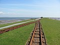
The main parking facility of the railway is located directly behind the new outer dike. In addition to the LKN-SH building yard, there is also a visitor center with the Lüttmoorsiel café. The outer dike itself is a hairpin run over and was on the lake side a first alternative location . This is followed by the dam of over 3 km in length. In the middle there is another escape point. On the Hallig, the line has been branching since 2004 to the Nordstrandischmoor station and Neu throw , which is the only one of the four terps on Nordstrandischmoor to have its own railway connection. In front of the terp a siding was set up as a winter station, from where the vehicles can be driven onto the terp when the Hallig (Landunter) floods. Concrete sleepers in bitumen are laid on the embankment, on which rails of the S33 profile lie.
Vehicles and traffic
Some of the vehicles belong to the LKN-SH. There are two locomotives , freight wagons for construction and two construction wagons that provide accommodation for workers during construction.
The remaining vehicles belong to the residents of Nordstrandischmoor. Every household has its own cart there. These are diesel-powered draisines , some with a trailer. Initially, the carts were propelled by sails through the wind. These vehicles are used exclusively for the islanders and their guests. Commercial traffic does not take place. In order to obtain the driving authorization, a minimum age of 15 years and are moped - driver's license required.
Lorenbahn
The local parlance speaks of Lorenbahn . Every vehicle - regardless of whether it is motorized or not - that drives the route is called a lorry . In this respect, the linguistic usage differs from the common railroad concept of the cart .
gallery

Vehicle park in the parking facility on the mainland
Hairpin on the top of the dike

The Lorendamm, in the background from left to right: Neuwarft, Amalienwarft, Halberwegwarft and Norderwarft

Alternative option on the dam

"Station" on the Hallig
TÜV badge for "Locomotive"

Abandoned stretch between Cecilienkoog and Lüttmoorsiel (the former embankment can be seen on the right of the canal)


See also
literature
- Marcus Petersen: The Halligen. Coastal protection - renovation - nature conservation. Wachholtz, Neumünster 1981, ISBN 3-529-06174-3 .
- Hans Wolfgang Rogl: The North Sea Island Railways. 6th edition. alba, Düsseldorf 1996, ISBN 3-87094-230-4 .
Web links
Individual evidence
Coordinates: 54 ° 32 ′ 58.9 " N , 8 ° 49 ′ 38.8" E