Hamburger Hallig
| Hamburger Hallig | ||
 Hamburger Hallig with the three buildings on the Hauptwarft |
||
| Geographical location | ||
|
|
||
| Coordinates | 54 ° 35 '58 " N , 8 ° 49' 8" E | |
| Waters 1 | North Sea | |
| Waters 2 | German Bight | |
| length | 4 km | |
| width | 2 km | |
| surface | 1.1 km² | |
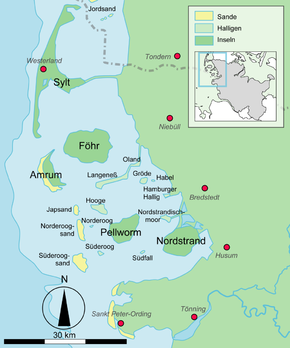
 Location of the islands and halligen in the North Frisian Wadden Sea |
||
The Hamburg Hallig ( Danish Hamborg hallig , Frisian Hamborjer Håli ) is a non- diked peninsula on the west coast of the district of North Friesland in Schleswig-Holstein .
history
The name of the Hallig is reminiscent of two Hamburg merchants, the brothers Rudolf and Arnold Amsinck . In 1624, as Oktroy, they acquired the dyke rights on the northeast corner of the island of Strand and built dykes by 1628. This is how the Amsinck- Koog came into being . The dikes were destroyed by the Burchardi flood in 1634. Only the terp with the "Hamburger Haus" remained and became a salvation for numerous Strander residents during the storm surge. After 1634 the dikes were rebuilt at great expense and survivors of the flood settled there. In 1658 Arnold Amsinck died in the "Hamburger Haus" in his Koog after he had put all his fortune into the re-dike. In 1661 the house was demolished and replaced by a smaller one. What happened was described in literature by the Husum writer Albert Petersen in his novel Arnold Amsinck (1921).
In 1711 the dikes were destroyed to such an extent that the Amsinck-Koog was a Hallig again. It remained in the possession of the Amsinck family until 1760. In 1781 the name "Hamburger Hallig" is mentioned for the first time. The house on the Hallig was destroyed by the February flood in 1825 .
In 1855 a connecting dam to the mainland was planned. The dam was built in 1859/60, but broke again in 1860. In 1866/67 a bush dam was built from Bordelumersiel to Hallig. This dam was fortified in 1874 and got an overflow point, which was closed in 1875. Due to the interruption of the tidal currents, the silting up on both sides of the dam was greatly accelerated. The experience gained here has decisively influenced the further development of land reclamation . In 1878 the tax authorities bought the Hallig and from then on leased it for management purposes. In 1880 an artesian well was built. The dam has been navigable since 1901.
In 1908 the Hallig was 96 hectares. On April 16, 1930 it was 216 hectares in size with the dike foreland and was declared a nature reserve to protect the avocet . Today it covers around 1,000 hectares together with the dike foreland of the Sönke-Nissen-Koog and the salt marshes and is looked after by the nature conservation association NABU .
geography
The Hamburg Hallig is no longer an island since it was connected to the mainland by a dam in 1860. Today it joins the foreland of the dike in front of the Sönke-Nissen-Koog and, like him, belongs to the Reußenköge municipality and district . Until 1899 it was a community-free manor district . An area of 79 hectares has been proven for the uninhabited manor district. The west coast of the Hallig is today largely secured against further land loss through fortification measures.
On September 30, 1928, the Hamburg Hallig was incorporated into the Reußenköge community .
While a land connection via a dam does not turn an island into a peninsula by definition , the salt marshes in front of the dam are added here.
Terps
The Hamburg Hallig has three terps (including a terp on the dike foreland and an undeveloped terp).
Hauptwarft
The main wharf on the Hamburg Hallig, four kilometers west of the sea dyke of the Sönke-Nissen-Kooges, has no name of its own. There are three buildings on it:
- "Hallig Krog" restaurant, which is open from Easter (April 1st at the latest) to October 31st
- A support point of the NationalparkService gGmbH (NPS) with an internship apartment (only inhabited temporarily in summer)
- "Watt workshop" (exhibition and laboratory of the NPS)
Kuhberg
About 300 meters south of the main mound is the Kuhberg on the Hallig, a low, undeveloped mound that serves as a rescue hill for sheep on light farms .
Schafberg
Two kilometers to the east, about halfway to the mainland, is the "Schafberg" terp with NABU station, the "Claus-Jürgen Reitmann-Haus". The accommodation is only temporarily occupied by volunteer NABU nature conservation officers. The Schafberg is in the foreland in front of the Sönke-Nissen-Koog, not on the actual Hamburg Hallig. Some sources therefore speak of only one inhabited terp on the Hamburg Hallig.
literature
- Claus J. Reitmann: The Hamburg Hallig . ISBN 3-7793-1123-2 .
- Arno Bammé and Thomas Steensen : Afterword. In: Albert Petersen: Arnold Amsinck. Nordfriesland im Roman, Volume 9, Husum 2015, pp. 271–344. ISBN 978-3-89876-794-1 .
Web links
Individual evidence
- ^ Karl Kuenz: Nordstrand after 1634. The re-diked North Frisian island ; [Singing] 1978, p. 111
- ↑ VO about the nature reserve Hamburger Hallig, district of North Friesland. In: Reg. Official Journal, p. 158. Landesportal Schleswig-Holstein, April 16, 1930, accessed on March 14, 2020 .
- ↑ Municipal directory 1900
- ^ Community encyclopedia for the Kingdom of Prussia based on the materials from the census of December 1, 1885 and other official sources. Province of Schleswig-Holstein, p. 48
- ↑ State Statistical Office Schleswig-Holstein: Historical municipality register Schleswig-Holstein 1867-1970, Kiel 1972 , p. 244
- ^ Hamburger Hallig at marschundfoerde


