
Kniepsand
| Kniepsand | ||
|---|---|---|
 |
||
| Waters | North Sea | |
| Geographical location | 54 ° 38 ′ N , 8 ° 20 ′ E | |
|
||
| length | 15 km | |
| width | 1.5 km | |
| surface | 10 km² | |
 |
||

The Kniepsand , formerly Knipsand ( Öömrang : a Kniip ) is an extremely slow moving sandbank in the North Sea . It is located west of the Schleswig-Holstein island of Amrum and covers an area of around 10 km². The Föhr-Amrum office specifies the area of Amrum with and without Kniepsand (30 and 20 km², respectively). Since the area is usually not flooded, it is high sand .
Surname
The name goes back to the Öömrang word kniap for "pinch".
geography
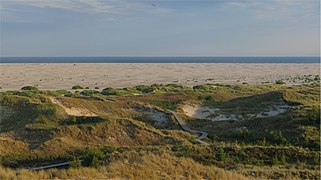
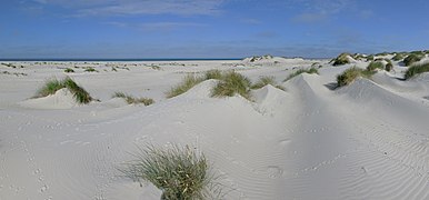
The Kniepsand forms a sandy beach that is apparently part of Amrum, 15 kilometers long and up to 1.5 kilometers wide , off the entire west coast of the island and directly merges into the sand dunes that actually belong to the island . However, from a geological point of view , the Kniepsand is not part of Amrum. Over the next few centuries, the Kniepsand is expected to migrate around the northern tip of Amrum, the Amrumer Odde . The Kniepsand acts as a natural island protection against storm surges and provides plenty of sand for the construction of the adjacent dune belt.
In winter, the Kniepsand is regularly washed over by high storm surges. The primary dunes created in the summer half of the year are often removed.
history
In 1585, the Kniepsand was mentioned on a nautical chart as Ameren bor, German: "Amrumer Barriere". At that time it was approximately at right angles to the island of Amrum. In the Middle Ages there was a fishing station at the level of today's Süddorf beach. With the increasing rotation of the Kniepsand towards the coast it silted up. From the middle of the 19th century the process accelerated. The Amrum sea rescue station was located at the height of the fog in 1865 and then had to be relocated several times northwards to Norddorfer Strand within two decades . The Kniephafen, which was protected by the Kniepsand in a creek near Norddorf, served large merchant ships as an anchorage in winter in the middle of the 19th century, and had to be relocated northwards in 1901, 1909 and 1938 due to the increasing siltation, until it was completely removed during the Second World War was abandoned. Until the mid-1960s, the Kniepsand was still separated from the island by the priel. Since then, the Kniepsand has continued to wander around the Amrumer Odde.
At the end of the 19th century, a branch of the Amrum island railway from Wittdün through the dunes to over the Kniepsand was built, but the rails and bathing buildings were immediately destroyed by the first storm surge in winter. The route was rebuilt several times and finally abandoned.
tourism
The Kniepsand acts as the beach on the island of Amrum. There are several guarded beaches and nudist sections. In some areas, vacationers use flotsam to build imaginative wooden structures that are removed again in autumn by the storm surges.
Nature and landscape protection
The Kniepsand is not part of the Schleswig-Holstein Wadden Sea National Park , but is registered as part of the fauna-flora-habitat area “Coastal and Dune Landscapes Amrum” in the European Natura 2000 network of protected areas . There are some areas that are closed to people. These include - with the exception of the flood edge - the Amrum-Odde nature reserve , the Kniepsand west of the Norddorf lighthouse and the southern tip of the Kniepsand near Wittdün . These areas serve as retreat or breeding areas for numerous bird species. It is also part of the "Amrum" nature reserve .
gallery
Kniepsand before Wittdün

On the Kniepsand near the beacon and cross-mark fire
Kniepsand with primary dunes
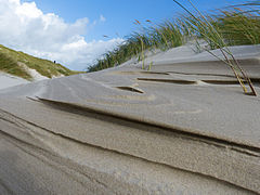
Dune on the Kniepsand

Kniepsand near Norddorf: On the left the Amrum dunes, on the right the Kniepsand
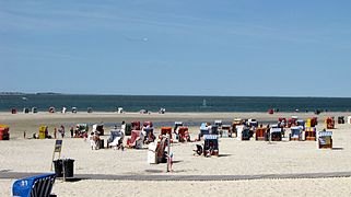
Beach life near Norddorf

Kniepsand after hurricane Xaver (2013)

Brooding arctic tern on the Kniepsand

.jpg)
.jpg)


Web links
Individual evidence
- ↑ August Krause: The island of Amrum. Stuttgart 1913
- ↑ Information at schleswig-holstein.de ( Memento from December 24, 2013 in the Internet Archive )
- ^ Office Föhr-Amrum: Office portrait
- ^ Georg Quedens , Hans Hingst, Gerhard piece, Ommo Wilts: Amrum. Landscape, history, nature . Jens Quedens Verlag, Amrum 1991, ISBN 3-924422-24-9 , p. 12
- ↑ Georg Quedens: Amrum . Breklumer Verlag, Breklum 1971
- ^ A b Georg Quedens , Hans Hingst, Gerhard Stück, Ommo Wilts: Amrum. Landscape, history, nature. Jens Quedens Verlag, Amrum 1991, ISBN 3-924422-24-9 , p. 14.

Islands in Denmark and Germany:
Amrum |
Fanø |
Foehr |
Koresand |
Langli |
Mandø |
Norderoogsand |
Pellworm |
Rømø |
Sylt |
Uthorn
Halligen:
Gröde |
Habel |
Hamburger Hallig |
Hooge |
Langeneß |
Norderoog |
Nordstrandischmoor |
Oland |
Süderoog |
South fall
High sands:
Japsand |
Jordsand |
Boy name sand |
Kniepsand |
Cormorant Island |
Süderoogsand