
Almdorf
| coat of arms | Germany map | |
|---|---|---|

|
Coordinates: 54 ° 35 ' N , 9 ° 1' E |
|
| Basic data | ||
| State : | Schleswig-Holstein | |
| Circle : | North Friesland | |
| Office : | Central North Friesland | |
| Height : | 3 m above sea level NHN | |
| Area : | 5.7 km 2 | |
| Residents: | 543 (Dec. 31, 2019) | |
| Population density : | 95 inhabitants per km 2 | |
| Postal code : | 25821 | |
| Area code : | 04671 | |
| License plate : | NF | |
| Community key : | 01 0 54 006 | |
| LOCODE : | DE 3AB | |
| Office administration address: | Theodor-Storm-Strasse 2 25821 Bredstedt, Germany |
|
| Website : | ||
| Mayor : | Olaf Held (WGA) | |
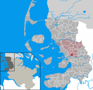
| Location of the municipality of Almdorf in the district of North Friesland | ||
  |
||

Almdorf ( Danish : Almtorp , partly also Almtrup , North Frisian : Aalmtoorp , Low German : Almdbod ) is a municipality in the district of North Friesland in Schleswig-Holstein . The community has no other districts besides Almdorf.


geography
Geographical location
The municipality of Almdorf extends on both sides of the transition from the Bredstedt-Drelsdorfer Geest to the Hattstedtermarsch , which is upstream here to the south, with the Arlau river, which drains here .
Neighboring communities
| Breklum | Drelsdorf | |
| Struckum |
.svg)
|
Bohmstedt |
| Hattstedtermarsch |
history
Archaeological finds prove a Paleolithic settlement in the municipality.
Almdorf originally belonged to the Schleswig Cathedral Chapter and was first mentioned in a document in 1352 in the Registrum capituli Slesvicensisa .
One theory says that the place name was derived from the old Germanic common land and thus means common land , according to another theory it comes from the old Danish ( Almthorp ) and means Ulmendorf . In the course of 1934, the parish district of Breklum was dissolved. All of their villages, village communities and farmers became independent communities / rural communities, on December 1, 1934 also Almdorf.
politics
Community representation
Since the local elections in 2008, the WGA voter community had all nine seats in the local council. In the local elections on May 6, 2018, all nine seats went to the WGA again, with a turnout of 47.25 percent.
mayor
Olaf Held (WGA) was elected mayor for the first time for the 2018–2023 election period.
Partner municipality
Almdorf has a partnership with Werder (Havel) in Brandenburg, previously with Bliesendorf , now incorporated.
Associations and regular events
The ring rider, rifle club and bowling club "Glück Zu" e. V. He is responsible for the annual summer festival. Another cultural bearer is the volunteer fire brigade .
Economy and Infrastructure
The economy in Almdorf is structured in very small parts. The structural change in agriculture has left its mark. There are only a few farms left, most of which have their home outside the settlement core. In addition, there are still small craft businesses, such as B. the blacksmith's shop and a regionally known gardening shop . Today the residential function takes the leading role for the small community.
traffic
The village of Almdorf is located away from the main North Frisian traffic axes. The place can be reached via a country road that branches off from federal road 5 in the neighboring town of Struckum directly at the entrance to the town . It leads past the southern outskirts of Almdorf.
To the west of the village, the Marschbahn crosses the connecting road at the entrance to Struckum . The nearest train stations are in Bredstedt (regional traffic) and Husum (long-distance traffic).
In public transport Almdorf has limited reach. There is a continuous line connection with regular traffic of the Schleswig-Holstein tariff along the federal highway 5 to Struckum. Another public bus also serves the town's school traffic to and from Breklum with limited traffic times.
Attractions
The village forge, built in the early 18th century, is still used as a forge today. It is now known nationwide among blacksmith enthusiasts.
In addition, the surroundings of Almdorf offer the opportunity to explore nature and landscape in an impressive way. For example, a 33 km long, signposted cycling circuit, the Ostenautal Route, begins in Almdorf.
Web links
Individual evidence
- ↑ North Statistics Office - Population of the municipalities in Schleswig-Holstein 4th quarter 2019 (XLSX file) (update based on the 2011 census) ( help on this ).
- ^ Jens Lampe: Tønder seminariestat , 1963, p. 96
- ↑ Aasbüttel - Bordesholm . In: Wolfgang Henze (ed.): Schleswig-Holstein topography: cities and villages of the country . 1st edition. tape 1 . Flying-Kiwi-Verl. Junge, Flensburg 2001, ISBN 3-926055-58-8 , p. 61 .
- ↑ State Statistical Office Schleswig-Holstein (Ed.): The population of the communities in Schleswig-Holstein 1867-1970 . State Statistical Office Schleswig-Holstein, Kiel 1972, p. 251 .
- ^ Historical municipality register Schleswig-Holstein: Notes on the municipality Almdorf (footnote) . ( genealogy.net ).
- ↑ Result of Almdorf municipal election 2013. ( Page no longer available , search in web archives ) Info: The link was automatically marked as defective. Please check the link according to the instructions and then remove this notice. Website of the Central North Friesland Office
- ↑ Schleswig-Holstein topography. Vol. 1: Aasbüttel - Bordesholm . 1st edition Flying-Kiwi-Verl. Junge, Flensburg 2001, ISBN 978-3-926055-58-3 , p. 61 ( dnb.de [accessed on July 29, 2020]).
Achtrup | Ahrenshöft | Ahrenviöl | Ahrenviölfeld | Alkersum | Almdorf | Arlewatt | Aventoft | Bargum | Behrendorf | Bohmstedt | Bondelum | Bordelum | Borgsum | Bosbull | Braderup | Bramstedtlund | Bredstedt | Breklum | Dagebüll | Drage | Drelsdorf | Dunsum | Elisabeth-Sophien-Koog | Ellhöft | Emmelsbüll-Horsbüll | Narrow Sands | Fresendelf | Friedrich-Wilhelm-Lübke-Koog | Friedrichstadt | Galmsbüll | Garding | Garding, parish | Goldebek | Goldelund | Gröde | Grothusenkoog | Haselund | Hattstedt | Hattstedtermarsch | Högel | Spar | Hooge | Hörnum (Sylt) | Horstedt | Hude | Humptrup | Husum | Immenstedt | Joldelund | Kampen (Sylt) | Karlum | Katharinenheerd | Klanxbüll | Klixbull | Koldenbüttel | Kolkerheide | Kotzenbüll | Ladelund | Langeneß | Langenhorn | Leak | Lexgaard | List on Sylt | Löwenstedt | Lütjenholm | Midlum | Mildstedt | Fog | Neukirchen | Nieblum | Niebüll | Norddorf on Amrum | Norderfriedrichskoog | North beach | Norstedt | Ockholm | Oevenum | Oldenswort | Oldersbek | Olderup | Oldsum | Ostenfeld (Husum) | Oster-Ohrstedt | Osterhever | Pellworm | Poppenbüll | Ramstedt | Rantrum | Reußenköge | Risum-Lindholm | Rodenäs | Sankt Peter-Ording | Schwabstedt | Schwesing | Seeth | Simonsberg | Sollwitt | Sönnebüll | Sprakebull | Stadum | Stedesand | Struckum | South end | Süderhöft | Süderlügum | South March | Sylt | Tating | Tetenbull | Tinningstedt | Tönning | Tümlauer-Koog | Uelvesbüll | Uphusum | Utersum | Viöl | Vollerwiek | Vollstedt | World | Wenningstedt-Braderup (Sylt) | Wester-Ohrstedt | Westerhever | Westre | Winnert | Wipe | Witsum | Wittbek | Wittdün on Amrum | Joke word | Wobbenbüll | Wrixum | Wyk on Föhr