
Westre
| coat of arms | Germany map | |
|---|---|---|

|
Coordinates: 54 ° 51 ' N , 8 ° 59' E |
|
| Basic data | ||
| State : | Schleswig-Holstein | |
| Circle : | North Friesland | |
| Office : | Südtondern | |
| Height : | 17 m above sea level NHN | |
| Area : | 19.13 km 2 | |
| Residents: | 358 (Dec. 31, 2019) | |
| Population density : | 19 inhabitants per km 2 | |
| Postal code : | 25926 | |
| Area code : | 04666 | |
| License plate : | NF | |
| Community key : | 01 0 54 154 | |
| Office administration address: | Marktstrasse 12 25899 Niebüll |
|
| Website : | ||
| Mayor : | Peter Max Hansen | |
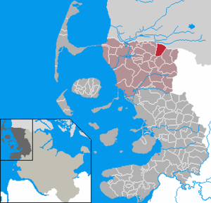
| Location of the municipality Westre in the district of North Friesland | ||
  |
||

Westre ( Danish : Vestre ) is a rural municipality in the northwestern area of the Schleswig Geest in the district of North Friesland in Schleswig-Holstein . The municipality extends south directly along the German-Danish border .
geography
Geographical location
The municipality of Westre extends in the northern part of the Schleswigsche Geest landscape . It is located in the landscape area of the historic Karrharde . The Alte Au (Danish: Gammelå) closes the municipality to the north.
Neighboring communities
Directly adjacent municipal areas are:
| Ellhöft | Tondern municipality (Denmark) | |
| Süderlügum |
.svg)
|
Ladelund |
| Lexgaard | Karlum |
geology
Geologically, the municipality is part of a sand area , which was formed at the end of the Saale complex . The geological overview map shows aeolian deposits with grain sizes from fine to medium sand for the municipality .
The Schwarzberger Moor nature reserve is located in the municipality . It is 18 hectares and was first established in 1966 and refurbished in 1994. The Schwarzberger Moor is an Atlantic high moor with low moor and heather areas . The moor is heavily peated and has an inland dune complex.
history
On August 13, 1984, a collision between a Cessna 172 Skyhawk and a McDonnell Douglas F-4 Phantom of Reconnaissance Wing 52 occurred at an altitude of about 500 meters above the municipality . The pilot of the Cessna was killed in the crash of his machine. The F-4 Phantom was able to land safely at Leck Air Base despite the loss of an external tank . Both inmates were uninjured. Today, near the crash site at the edge of the forest, a wooden cross commemorates the accident.
politics
Community representation
In the local elections on May 6, 2018 , the voter community (WGW) won six and the South Schleswig voter association (SSW) won three. The turnout was 65.0 percent.
coat of arms
Blazon : "In gold on a flat vaulted green three-mountain, this is covered with a 24-piece silver water lily flower with golden clusters, two black fir trees."
economy
The municipality is dominated by agriculture. These include the total of four biogas plants in the municipality.
- Citizen wind farm
Grenzstrom Vindtved GmbH & Co. KG's community wind farm has a stake of more than 200 limited partners from the municipalities of Westre, Ellhöft and Lydersholm in Denmark .
In March 2009 were Bürgerwindpark Westre three wind turbines of the type REpower 6M built. The systems with a nominal output of six megawatts each, with a rotor diameter of 126 m and a hub height of 100 m, are among the largest wind turbines ever. The rotor blades, each 61.5 meters long, came directly from Denmark by heavy load . The nacelles were in Bremerhaven REpower made -Werk. They reached Dagebüll by sea , from where they were transported overland to Westre by heavy haulage.
The systems were developed by REpower engineers for use in offshore wind farms . They are extensively tested and certified in the Westre community wind farm. For this reason, work on the wind turbines takes place regularly.
traffic
The municipality is roughly crossed by the state roads 1 and 192 in a west-east direction. Landesstraße 1 runs through the village center , while the so-called border road 192 runs through the northern part of the district. Both branch off from Bundesstraße 5 in the neighboring community of Süderlügum . As the main traffic route in North Frisia, this was described many times in the past as the holiday route Green Coastal Road .
See also
Web links
Individual evidence
- ↑ North Statistics Office - Population of the municipalities in Schleswig-Holstein 4th quarter 2019 (XLSX file) (update based on the 2011 census) ( help on this ).
- ↑ cf. Geological overview map of Schleswig-Holstein 1: 250,000. State Office for Agriculture, Environment and Rural Areas (Geological Service), accessed on May 18, 2020 .
- ↑ 5411 - Schwarzberger Moor. (pdf) Retrieved May 17, 2020 .
- ^ Aviation Safety Network. Retrieved July 6, 2016 .
- ^ Aviation Safety Network. Retrieved July 6, 2016 .
- ^ Chronicle of AG 52 - Part 1. In: Pages 40/41. Retrieved July 6, 2016 .
- ^ Chronicle of AG 52 - Part 3. In: Page 224. Retrieved on July 6, 2016 .
- ↑ Web editing: Result of local election Westre 2018. In: www.amt-suedtondern.de. South Tondern Office, accessed on October 16, 2018 .
- ↑ Schleswig-Holstein's municipal coat of arms
- ↑ First wind farm with REpower 6M turbines. Retrieved March 17, 2013 .
- ↑ 24.03.09 - Westre community wind farm completed. Retrieved March 17, 2013 .
- ↑ REpower.de ( Memento from April 12, 2013 in the web archive archive.today )
- ↑ so z. B. at Iba, Eberhard Michael and Walter Iba: The Green Coastal Road from Emden to Westerland. Verlag Friedrich Pustet , Regensburg, 1981, ISBN 3791706950
Achtrup | Ahrenshöft | Ahrenviöl | Ahrenviölfeld | Alkersum | Almdorf | Arlewatt | Aventoft | Bargum | Behrendorf | Bohmstedt | Bondelum | Bordelum | Borgsum | Bosbull | Braderup | Bramstedtlund | Bredstedt | Breklum | Dagebüll | Drage | Drelsdorf | Dunsum | Elisabeth-Sophien-Koog | Ellhöft | Emmelsbüll-Horsbüll | Narrow Sands | Fresendelf | Friedrich-Wilhelm-Lübke-Koog | Friedrichstadt | Galmsbüll | Garding | Garding, parish | Goldebek | Goldelund | Gröde | Grothusenkoog | Haselund | Hattstedt | Hattstedtermarsch | Högel | Spar | Hooge | Hörnum (Sylt) | Horstedt | Hude | Humptrup | Husum | Immenstedt | Joldelund | Kampen (Sylt) | Karlum | Katharinenheerd | Klanxbüll | Klixbull | Koldenbüttel | Kolkerheide | Kotzenbüll | Ladelund | Langeneß | Langenhorn | Leak | Lexgaard | List on Sylt | Löwenstedt | Lütjenholm | Midlum | Mildstedt | Fog | Neukirchen | Nieblum | Niebüll | Norddorf on Amrum | Norderfriedrichskoog | North beach | Norstedt | Ockholm | Oevenum | Oldenswort | Oldersbek | Olderup | Oldsum | Ostenfeld (Husum) | Oster-Ohrstedt | Osterhever | Pellworm | Poppenbüll | Ramstedt | Rantrum | Reußenköge | Risum-Lindholm | Rodenäs | Sankt Peter-Ording | Schwabstedt | Schwesing | Seeth | Simonsberg | Sollwitt | Sönnebüll | Sprakebull | Stadum | Stedesand | Struckum | South end | Süderhöft | Süderlügum | South March | Sylt | Tating | Tetenbull | Tinningstedt | Tönning | Tümlauer-Koog | Uelvesbüll | Uphusum | Utersum | Viöl | Vollerwiek | Vollstedt | World | Wenningstedt-Braderup (Sylt) | Wester-Ohrstedt | Westerhever | Westre | Winnert | Wipe | Witsum | Wittbek | Wittdün on Amrum | Joke word | Wobbenbüll | Wrixum | Wyk on Föhr