Elisabeth-Sophien-Koog
| coat of arms | Germany map | |
|---|---|---|

|
Coordinates: 54 ° 31 ' N , 8 ° 53' E |
|
| Basic data | ||
| State : | Schleswig-Holstein | |
| Circle : | North Friesland | |
| Office : | North Sea Treene | |
| Height : | 1 m above sea level NHN | |
| Area : | 5.18 km 2 | |
| Residents: | 49 (Dec. 31, 2019) | |
| Population density : | 9 inhabitants per km 2 | |
| Postal code : | 25845 | |
| Area code : | 04842 | |
| License plate : | NF | |
| Community key : | 01 0 54 026 | |
| Office administration address: | Schulweg 19 25866 Mildstedt |
|
| Website : | ||
| Mayoress : | Ute Clausen | |
| Location of the community Elisabeth-Sophien-Koog in the district of North Friesland | ||
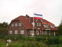
Elisabeth-Sophien-Koog , also called Bodderkoog (Low German for Butterkoog) by the locals , is a municipality on the North Frisian peninsula (until 1987: Insel) Nordstrand .
history
As a result of the Burchardi flood of 1634, it was not possible for the Nordstranders to regain the lost land or to secure the remaining land against further flooding with their own means. The sovereign, Duke Friedrich III. von Schleswig-Holstein-Gottorf finally transferred in 1652 the Brabant Quirinus Indervelden and three other Dutchmen in an octroy all lands with the requirement of re-dike-up. So in 1656 the Friedrichskoog was created - named after the duke himself -, in 1657 the Marie-Elisabeth-Koog (or Osterkoog) named after the duchess , in 1663 the Trendermarschkoog and after a long dispute among the now 24 participants in 1691 the Neue Koog. But before the foreland, which had grown under the protection of the Köge, could be dammed, the series of storm tides from 1717 to 1720 made the protection of the existing Köge priority. Therefore, it was not until 1739 that after King Christian VI. Christianskoog, called by Denmark, completed by the Dutch, covering 570 hectares. But as early as 1751, another storm surge destroyed the dikes. In the meantime, the Dutch participants were so financially ruined by the frequent dike breaches that they had sold their property to the resurgent local population. However, this did not have the additional means to obtain a new Koog.
In 1768, Jean Henri Desmercières , who had already successfully demonstrated his skills with the first dikes in the Bredstedter Buch ( Sophie-Magdalenen-Koog and Desmerciereskoog ), acquired the right to re-dike the destroyed Christianskoog. The prerogatives of the original Octroy of 1652 passed to him and his heirs. A royal resolution of 1771 granted him seven years of tax exemption in addition to the previous seven years. Desmercières had a new, gently rising dike built on the lake side and named the Koog after his wife Elisabeth Sophie Countess de Friis (1714–1799). As early as 1770 he was soliciting buyers and tenants for the new land, which would be available for settlement from June 1771. As in the Reußenkögen, he took on the construction of drainage and the road network. Mainly old Nordstrander families settled in the new Koog, which was allowed to self-govern after the Octroy. The Koog has retained this special position to this day.
During the storm surge of 1825 , the dikes broke and the Nordstrander Köge was flooded. However, the dyke built by Desmercières had held, so that the other dykes with the flatter profile were rebuilt. In connection with the high repair costs of the other Nordstrander Köge, the then Staller - royal administrative officer - from Nordstrand demanded the inclusion of Elisabeth-Sophien-Koog in a dyke cooperative. But Desmercières' heirs defended the independence before the Gottorf High Court .
In 1895 the municipality of Nordstrand submitted an application for a merger with Elisabeth-Sophien-Koog, which was favored by its location in terms of the cost of dike and infrastructure maintenance. The district committee in Husum rejected the application, which it justified with the added value of the small community. It was not until 1957 that Elisabeth-Sophien-Koog joined the Nordstrand dike and sewer association.
politics
Since the community has fewer than 70 inhabitants, representation takes place through a community assembly ; this includes all citizens of the community who are entitled to vote.
Mayoress
At the municipal assembly on June 26, 2018, Ute Clausen was repeatedly elected mayor in the first ballot.
coat of arms
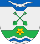
Blazon : “By a wide silver bar cut out with beveled nicks, inside two crossed green spades, of blue, inside a silver seagull, and green, inside a golden marsh yolk flower, divided over a silver wave shield with blue wave bars in a ratio of 1: 3: 2 . "
Economic and infrastructure
Established businesses
There is a campsite in Elisabeth-Sophien-Koog. This is located directly on the outer dike. Among other things, there is also a stud in the Koog , which focuses on horse breeding with Friesian horses .
traffic
The community is very rural. The connection is mainly by car via the Schleswig-Holstein state road 30 . In Pohnshalligkoog , shortly before the Mitteldeich to Morsumkoog, a country road branches off to the right (K 68), which then crosses the Elisabeth-Sophien-Koog in a longitudinal direction and ends at the Landesschutzdeich in the immediate vicinity of Holmer Siel .
There is no direct connection to the regional bus network in local public transport . The regional bus route R140 from Husum to Nordstrand only goes to the neighboring district of England . On August 1, 2019, an on- call bus system was set up on Nordstrand Island . Starting from the central transfer station Nordstrand, Herrendeich / Schule , the stops in Elisabeth-Sophien-Koog are also connected.
Personalities
Peter Harry Carstensen , Minister-President of Schleswig-Holstein from 2005 to 2012, was born in Elisabeth-Sophien-Koog in 1947 and lived in the community until 2012.
Web links
Individual evidence
- ↑ North Statistics Office - Population of the municipalities in Schleswig-Holstein 4th quarter 2019 (XLSX file) (update based on the 2011 census) ( help on this ).
- ^ Office North Sea Treene - Elisabeth-Sophien-Koog. Retrieved September 8, 2019 .
- ↑ 01. GV Elisabeth-Sophien-Koog on June 26, 2018. (pdf) Retrieved September 8, 2019 .
- ↑ Schleswig-Holstein's municipal coat of arms
- ↑ Route book for bus route R140. (pdf) Retrieved September 8, 2019 .
- ↑ Flyer on call bus north beach. (pdf) Retrieved September 8, 2019 .


