
Tetenbull
| coat of arms | Germany map | |
|---|---|---|

|
Coordinates: 54 ° 21 ' N , 8 ° 50' E |
|
| Basic data | ||
| State : | Schleswig-Holstein | |
| Circle : | North Friesland | |
| Office : | Eiderstedt | |
| Height : | 2 m above sea level NHN | |
| Area : | 36.48 km 2 | |
| Residents: | 587 (Dec. 31, 2019) | |
| Population density : | 16 inhabitants per km 2 | |
| Postal code : | 25882 | |
| Primaries : | 04862, 04864, 04865 | |
| License plate : | NF | |
| Community key : | 01 0 54 135 | |
| Office administration address: | Welter Strasse 1 25836 Garding |
|
| Website : | ||
| Mayor : | Thomas Lorenzen ( CDU ) | |
| Location of the municipality of Tetenbüll in the district of North Friesland | ||
  |
||

Tetenbüll (Danish: Tetenbøl) is a municipality on the Eiderstedt peninsula in the district of North Friesland . It is administered by the Eiderstedt office. Kaltenhörn, Warmhörn, Wasserkoog and Sieversfleth are in the municipality.
geography
Geographical location
The municipality of Tetenbüll extends on the northern edge of the Eiderstedt peninsula about eight kilometers northwest of Tönning and twelve kilometers northeast of St. Peter-Ording in the large Eiderstedter Marsch area .
The marshland island of Eiderstedt, which was surrounded by a 1.5 meter high summer dike in the 12th century , was expanded to the north from the end of the 14th century. After the devastating Second Marcellus Flood of 1362, the Tetenbüller church and the Tetenbüller Osterkoog were first made land-based in the late 14th century. They were followed over the next two centuries:
- Tetenbüller Marschkoog (around 1400)
- Reinsbüllkoog (around 1400)
- Tetenbüller Trockenkoog (1475)
- Adenbüller Koog (1529)
- Altneukoog (1559)
- Sieversflether Koog (1610)
- Wasserkoog (1617)
The eastern part of the Norderheverkoog, which was diked in 1937, also belongs to the municipality . Warmhörn and (partly) Kaltenhörn are also districts of Tetenbüll.
Neighboring communities
Bordering on Tetenbüll:
| Osterhever | Norderfriedrichskoog | |
| Poppenbull |
.svg)
|
Oldens word |
| Garding (parish) | Katharinenheerd | Kotzenbüll |
The Wadden Sea area of the Heverstrom joins in to the north .
church
A first chapel was built around 1113; Today's St. Anna Church was built around 1400 after the Tetenbüller Kirchenkooges was dyed . The wooden beam ceiling is adorned with an 18th century painting showing the path of Christ. Thirty scenes from the Old Testament are shown in pictures on the north gallery from 1612 .
Tetenbüll forms a parish with Katharinenheerd.
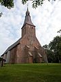
Tetenbüll, St. Anna

St. Anna, wood-carved altarpiece


politics
Community representation
- Of the nine seats in the municipal council, the CDU had four seats since the 2008 local elections, the KWT electoral community had three and the Greens had two seats.
- In the local elections on May 26, 2013, the CDU received 43.6% of the votes cast and received four seats. The Greens got 29.2% and three seats. The Tetenbüll Municipal Voting Association (KWT) had 27.3% and two seats. The turnout was 63.27 percent.
mayor
Thomas Lorenzen (CDU) was elected as the new mayor for the 2013–2018 election period. He succeeded Henning Möller (CDU) who held the office for 23 years.
Economy and Infrastructure
General economic structure
The municipal area is predominantly structured agriculturally, but there are also some commercial enterprises and a port. Tourism is also an important source of income for the community.
Transport links
South of the village, the federal highway 202 and the Husum – Bad St. Peter-Ording railway line pass through the neighboring village of Katharinenheerd.
The train stop of the same name is served by all trains on line RB 64 of the Schleswig-Holstein local transport network . In Husum you can change to long-distance trains . Various intercity lines stop here , which run through Hamburg via the march railway to Westerland on Sylt.
Sports
- The gymnastics and sports club TSV Tetenbüll e. V. from 1951 offers popular sports in the fields of volleyball, gymnastics, soccer, badminton, gymnastics, dancing and floorball.
- The Ringreiterverein offers a special equestrian sport. A ring of different sizes is to be speared at a gallop with a lance.
- The Boßeln is powered by two clubs in the community. The men are in the Boßelverein from 1894 e. V. organized; the women pursue this sport in the Fruunsboßelverein .
Public facilities
- There is a kindergarten and a primary school in the community. The latter is a branch of the Theodor Mommsen Elementary School in Garding.
- Fire protection is ensured by the Tetenbüll volunteer fire brigade, founded in 1934 . She is also responsible for the Katharinenheerd municipality.
Attractions
Sons and daughters of the church
- Johannes Nikolaus Tetens (1736–1807), German philosopher, mathematician and natural scientist of the Enlightenment
- Richard Harder (1896–1957), philologist
- Philipp Johannsen (1864–1937), German politician ( Schleswig-Holstein Peasant and Agricultural Workers' Democracy (SHBLD))
- Heinz Kähler (1905–1974), German archaeologist
literature
- Hans-Walter Wulf: Churches in Eiderstedt. Lühr & Dircks, St. Peter-Ording 1981, ISBN 3-921416-13-2 , pp. 60-64.
Web links
Individual evidence
- ↑ North Statistics Office - Population of the municipalities in Schleswig-Holstein 4th quarter 2019 (XLSX file) (update based on the 2011 census) ( help on this ).
- ↑ Schleswig-Holstein topography. Vol. 9: Schönberg - Tielenhemme . 1st edition Flying-Kiwi-Verl. Junge, Flensburg 2007, ISBN 978-3-926055-91-0 , p. 366 ( dnb.de [accessed on August 6, 2020]).
- ↑ in brackets the respective dike times
- ↑ cf. Kunz, Harry: Die Köge Nordfriesland , 2nd edition, Nordfriisk Instituut, Bräist / Bredstedt, 1999
- ^ Hans-Walter Wulf: Churches in Eiderstedt. Lühr & Dircks, St. Peter-Ording 1981, p. 60 f.
- ↑ [wahlen.amt-eiderstedt.de/2013/kommunal/tetenbüll] accessed on May 27, 2013
- ↑ The second attempt, Husumer Nachrichten from July 5, 2013, worked, accessed on July 6, 2013
Achtrup | Ahrenshöft | Ahrenviöl | Ahrenviölfeld | Alkersum | Almdorf | Arlewatt | Aventoft | Bargum | Behrendorf | Bohmstedt | Bondelum | Bordelum | Borgsum | Bosbull | Braderup | Bramstedtlund | Bredstedt | Breklum | Dagebüll | Drage | Drelsdorf | Dunsum | Elisabeth-Sophien-Koog | Ellhöft | Emmelsbüll-Horsbüll | Narrow Sands | Fresendelf | Friedrich-Wilhelm-Lübke-Koog | Friedrichstadt | Galmsbüll | Garding | Garding, parish | Goldebek | Goldelund | Gröde | Grothusenkoog | Haselund | Hattstedt | Hattstedtermarsch | Högel | Spar | Hooge | Hörnum (Sylt) | Horstedt | Hude | Humptrup | Husum | Immenstedt | Joldelund | Kampen (Sylt) | Karlum | Katharinenheerd | Klanxbüll | Klixbull | Koldenbüttel | Kolkerheide | Kotzenbüll | Ladelund | Langeneß | Langenhorn | Leak | Lexgaard | List on Sylt | Löwenstedt | Lütjenholm | Midlum | Mildstedt | Fog | Neukirchen | Nieblum | Niebüll | Norddorf on Amrum | Norderfriedrichskoog | North beach | Norstedt | Ockholm | Oevenum | Oldenswort | Oldersbek | Olderup | Oldsum | Ostenfeld (Husum) | Oster-Ohrstedt | Osterhever | Pellworm | Poppenbüll | Ramstedt | Rantrum | Reußenköge | Risum-Lindholm | Rodenäs | Sankt Peter-Ording | Schwabstedt | Schwesing | Seeth | Simonsberg | Sollwitt | Sönnebüll | Sprakebull | Stadum | Stedesand | Struckum | South end | Süderhöft | Süderlügum | South March | Sylt | Tating | Tetenbull | Tinningstedt | Tönning | Tümlauer-Koog | Uelvesbüll | Uphusum | Utersum | Viöl | Vollerwiek | Vollstedt | World | Wenningstedt-Braderup (Sylt) | Wester-Ohrstedt | Westerhever | Westre | Winnert | Wipe | Witsum | Wittbek | Wittdün on Amrum | Joke word | Wobbenbüll | Wrixum | Wyk on Föhr