Vollstedt
| coat of arms | Germany map | |
|---|---|---|

|
Coordinates: 54 ° 37 ' N , 9 ° 2' E |
|
| Basic data | ||
| State : | Schleswig-Holstein | |
| Circle : | North Friesland | |
| Office : | Central North Friesland | |
| Height : | 9 m above sea level NHN | |
| Area : | 6.18 km 2 | |
| Residents: | 183 (Dec. 31, 2019) | |
| Population density : | 30 inhabitants per km 2 | |
| Postal code : | 25821 | |
| Area code : | 04671 | |
| License plate : | NF | |
| Community key : | 01 0 54 146 | |
| Office administration address: | Theodor-Storm-Strasse 2 25821 Bredstedt, Germany |
|
| Website : | ||
| Mayor : | Sabine Nahnsen (FWV) | |
| Location of the community Vollstedt in the district of North Friesland | ||
Vollstedt ( Danish Folsted , Frisian : Fåålst ) is a municipality in the district of North Friesland in Schleswig-Holstein .
Geography and traffic
Vollstedt is located in the natural area of the Hohe Geest in central North Friesland. The Bredstedt sub-center is located about three kilometers to the west . The two most important traffic axes run here in a north-south direction, federal highway 5 as part of the former Green Coastal Road and the Marschbahn railway line .
history
On April 1, 1934, the parish of Breklum was dissolved. All of their village communities, village communities and farmers became independent communities / rural communities, including Vollstedt.
religion
75% of the population are Protestant, 6% Catholic. The Protestants belong to the parish of Breklum in the parish of North Friesland of the Evangelical Lutheran Church in North Germany . The Catholics are assigned to the parish of St. Knud in Husum , Archdiocese of Hamburg , whose next branch church is St. Marien in Bredstedt .
politics
Community representation
Since the local elections in 2008, the Free Voting Community Vollstedt (FWV) had all seven seats in the municipal council. In the local elections on May 26, 2013, the FWV held its seven seats with a turnout of 58.6 percent.
In the local elections on May 6, 2018, only candidates from the FWV were elected to the new local council.
mayor
At the constituent meeting of the municipal council on June 13, 2018, Sabine Nahnsen was elected as the new mayor of Vollstedt for the 2018–2023 election period. She replaced the long-time mayor of the community and most recently acting head of the office of Central North Friesland, Hans-Jakob Paulsen.
coat of arms
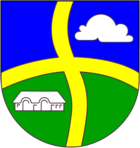
Blazon : “Blue from above and green below, divided by a golden cross with wavy bars. In the left upper field a silver cloud, in the right lower field a silver house silhouette. "
economy
The municipality is predominantly agricultural.
Web links
Individual evidence
- ↑ North Statistics Office - Population of the municipalities in Schleswig-Holstein 4th quarter 2019 (XLSX file) (update based on the 2011 census) ( help on this ).
- ↑ State Statistical Office Schleswig-Holstein (Ed.): The population of the communities in Schleswig-Holstein 1867-1970 . State Statistical Office Schleswig-Holstein, Kiel 1972, p. 251 .
- ↑ census database
- ↑ Result of the municipal election in Vollstedt 2013. ( Memento of the original from June 25, 2013 in the Internet Archive ) Info: The archive link was automatically inserted and not yet checked. Please check the original and archive link according to the instructions and then remove this notice. on the website Amt Mittleres Nordfriesland
- ^ Announcement of the municipal election results in the municipality of Vollstedt. (pdf) Retrieved May 26, 2019 .
- ^ Minutes of the constituent meeting of the Vollstedt community council. (pdf) Retrieved May 26, 2019 .
- ↑ Schleswig-Holstein's municipal coat of arms


