
Rodenäs
| coat of arms | Germany map | |
|---|---|---|

|
Coordinates: 54 ° 53 ' N , 8 ° 42' E |
|
| Basic data | ||
| State : | Schleswig-Holstein | |
| Circle : | North Friesland | |
| Office : | Südtondern | |
| Height : | 2 m above sea level NHN | |
| Area : | 19.84 km 2 | |
| Residents: | 406 (Dec. 31, 2019) | |
| Population density : | 20 inhabitants per km 2 | |
| Postal code : | 25924 | |
| Primaries : | 04668 also 04664 | |
| License plate : | NF | |
| Community key : | 01 0 54 110 | |
| Office administration address: | Marktstrasse 12 25899 Niebüll |
|
| Website : | ||
| Mayor : | Jörg Nissen (AWR) | |
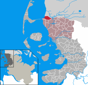
| Location of the municipality of Rodenäs in the district of North Friesland | ||
  |
||

Rodenäs ( Danish : Rødenæs , North Frisian : Runees or Rornees , South Jutian : Rånæjs ) is a municipality in the district of North Friesland in Schleswig-Holstein . It marks the northernmost point of the German mainland.
geography
Geographical location
The municipality of Rodenäs extends in the north of the North Frisian Marsch landscape south of the mouth of the Wiedau (Danish: Vidå) near the Danish town of Hoyer in the historical landscape and administrative district of the Wiedingharde on the German-Danish border .
Community structure
Oldorf (Danish Gammelby , North Frisian Uuiltorp ), Neudorf (Danish Nyby , North Frisian Naitorp ), Markhäuser, Ophusum, Kixbüll and the nature reserve Rickelsbüller Koog (Danish Rikkelsbøl Kog , North Frisian Rikelsbeler Kuuch ) are located in the municipality.
Neighboring communities
Directly adjacent municipal areas are:
| Tondern municipality (Denmark) | ||
.svg)
|
Neukirchen | |
| Friedrich-Wilhelm-Lübke-Koog | Klanxbull |
geology
The soil in the municipality is marshland . It is part of the following table (year of verification):
- Wiedingharder Alter Koog (northern section) (1465)
- Brunottenkoog (parts to the west) (1618)
- Dreieckskoog (northern part) (1925)
- Rickelsbüller Koog (1982)
Depending on the age since it was dyed, the soil is now mainly classified as Kleimarsch . Due to the absolutely flat relief, as well as the low location near the coast at or just below sea level in the hinterland of the North Frisian Wadden Sea , active drainage of the municipality is a fundamental necessity for agricultural use in the field of arable farming . The responsible sewer associations are legally responsible for the drainage . In detail these are:
- Sielverband Wiedingharder Alter Koog north
- Sielverband Brunottenkoog
Both are members of the superordinate dyke and main sewer association Südwesthörn-Bongsiel .
climate
The climate in Rodenäs is assigned to class CfB ( maritime climate ) based on the Köppen and Geiger climate classification.
history

In 1436 the first dike called the Golden Ring was built around the Wiedingharde .
The western part of the late Romanesque church standing on a terp in the Oldorf district was built from the remains of the Rickelsbüller church, which was sunk in the great flood of December 1, 1615 along with its village.
The Rickelsbüller Koog is named after this village.
politics
Community representation
In the local elections on May 6, 2018, the general electorate (AWR) got 61.3 percent and six seats in the municipal council, the voter community I (WG I) received 38.7 percent of the votes and three seats.
In the previous local election on May 26, 2013, the general electorate (AWR) received 51.3 percent (five seats in the municipal council), the voter community I (WG I) 25.0 percent (two seats), as did the Südschleswigsche Voters' Association (SSW) with 23.7 percent.
coat of arms
Blazon : “Divided by red and blue by a golden arch to the head of the shield. Above is a golden, waxing crescent moon, to the right and left a six-pointed star. Below is a silver windmill. "
Culture
language
In a study in the 1970s, the University of Copenhagen found that 28% of the residents spoke High German , Low German , Frisian , Standard Danish and South Jutish and were thus five languages. In the meantime, however, standard German monolingualism is gradually gaining ground.
Economy and Infrastructure
The outer area of the municipality is characterized by primary agricultural production . This area is supplemented by the generation of electricity from renewable energy sources . The Rodenäs solar park is located in the municipality.
traffic
The community is located on Schleswig-Holstein Landesstrasse 271. This branches off from Landesstrasse 6 in the local area of the neighboring community of Neukirchen .
In public transport , the place is reachable in sporadic bus traffic of the transport interconnection Schleswig-Holstein . Since August 2019, the district of North Friesland has also designed on - call bus areas to complement the above quasi school bus traffic. The municipality of Rodenäs is assigned to the Klanxbüll / Emmelsbüll on- call bus area with the central transfer station Klanxbüll Bahnhof . The train station is the closest train station for local rail passenger transport . He is at the march run . The nearest train station with a connection to the long-distance traffic of the Intercity network is Niebüll (DB) train station . Trains from IC lines 26.1 , 27 and 30 stop there at least once a day in each direction from / to Westerland .
See also
Web links
Individual evidence
- ↑ North Statistics Office - Population of the municipalities in Schleswig-Holstein 4th quarter 2019 (XLSX file) (update based on the 2011 census) ( help on this ).
- ↑ General Staff Kort over Slesvigs Fastland og Als, Kjøbenhavn 1858
- ↑ Nordfriesland map, Bredstedt / Braist 2011, ISBN 978-3-88007-371-5
- ↑ Schleswig-Holstein topography. Vol. 8: Pölitz - Schönbek . 1st edition Flying-Kiwi-Verl. Junge, Flensburg 2007, ISBN 978-3-926055-89-7 , pp. 189 ( dnb.de [accessed on July 23, 2020]).
- ↑ Relation Rodenäs at Openstreetmap. Accessed May 31, 2020 .
- ↑ taken from Harry Kunz / Albert Panten: Die Köge Nordfrieslands. Verlag Nordfriisk Instituut, Bräist / Bredstedt, 2nd edition, 1999
- ↑ Member associations on the DHSV Südwesthörn-Bongsiel website. Accessed June 1, 2020 .
- ↑ Climate in Rodenäs on de.climate-data.org. Accessed June 1, 2020 .
- ↑ Web editing: Results of the local election Rodenäs 2018. In: www.amt-suedtondern.de. South Tondern Office, accessed on November 8, 2018 .
- ↑ Web editor: Results of the 2013 municipal elections in the South Tondern office. In: www.amt-suedtondern.de. Office Südtondern, accessed on June 22, 2013 .
- ↑ Schleswig-Holstein's municipal coat of arms
- ↑ Website of the municipality of Rodenäs , accessed on November 14, 2014
- ↑ Flyer on-call bus area Klanxbüll / Neukirchen. Retrieved June 3, 2020 .
Achtrup | Ahrenshöft | Ahrenviöl | Ahrenviölfeld | Alkersum | Almdorf | Arlewatt | Aventoft | Bargum | Behrendorf | Bohmstedt | Bondelum | Bordelum | Borgsum | Bosbull | Braderup | Bramstedtlund | Bredstedt | Breklum | Dagebüll | Drage | Drelsdorf | Dunsum | Elisabeth-Sophien-Koog | Ellhöft | Emmelsbüll-Horsbüll | Narrow Sands | Fresendelf | Friedrich-Wilhelm-Lübke-Koog | Friedrichstadt | Galmsbüll | Garding | Garding, parish | Goldebek | Goldelund | Gröde | Grothusenkoog | Haselund | Hattstedt | Hattstedtermarsch | Högel | Spar | Hooge | Hörnum (Sylt) | Horstedt | Hude | Humptrup | Husum | Immenstedt | Joldelund | Kampen (Sylt) | Karlum | Katharinenheerd | Klanxbüll | Klixbull | Koldenbüttel | Kolkerheide | Kotzenbüll | Ladelund | Langeneß | Langenhorn | Leak | Lexgaard | List on Sylt | Löwenstedt | Lütjenholm | Midlum | Mildstedt | Fog | Neukirchen | Nieblum | Niebüll | Norddorf on Amrum | Norderfriedrichskoog | North beach | Norstedt | Ockholm | Oevenum | Oldenswort | Oldersbek | Olderup | Oldsum | Ostenfeld (Husum) | Oster-Ohrstedt | Osterhever | Pellworm | Poppenbüll | Ramstedt | Rantrum | Reußenköge | Risum-Lindholm | Rodenäs | Sankt Peter-Ording | Schwabstedt | Schwesing | Seeth | Simonsberg | Sollwitt | Sönnebüll | Sprakebull | Stadum | Stedesand | Struckum | South end | Süderhöft | Süderlügum | South March | Sylt | Tating | Tetenbull | Tinningstedt | Tönning | Tümlauer-Koog | Uelvesbüll | Uphusum | Utersum | Viöl | Vollerwiek | Vollstedt | World | Wenningstedt-Braderup (Sylt) | Wester-Ohrstedt | Westerhever | Westre | Winnert | Wipe | Witsum | Wittbek | Wittdün on Amrum | Joke word | Wobbenbüll | Wrixum | Wyk on Föhr