Uelvesbull
| coat of arms | Germany map | |
|---|---|---|

|
Coordinates: 54 ° 25 ' N , 8 ° 56' E |
|
| Basic data | ||
| State : | Schleswig-Holstein | |
| Circle : | North Friesland | |
| Office : | North Sea Treene | |
| Height : | 0 m above sea level NHN | |
| Area : | 10.23 km 2 | |
| Residents: | 300 (Dec. 31, 2019) | |
| Population density : | 29 inhabitants per km 2 | |
| Postal code : | 25889 | |
| Area code : | 04864 | |
| License plate : | NF | |
| Community key : | 01 0 54 141 | |
| Office administration address: | Schulweg 19 25866 Mildstedt |
|
| Website : | ||
| Mayor : | Holger Suckow (WVUe) | |
| Location of the community of Uelvesbüll in the district of North Friesland | ||
Uelvesbüll ( Danish : Ylvesbøl) is a municipality in the district of North Friesland in Schleswig-Holstein .
geography
Uelvesbüll is a rural municipality that was formed from the districts of Uelvesbüll and Barneckermoor. It is located about ten kilometers southwest of Husum on the Eiderstedt peninsula on the Heverstrom . A few kilometers to the east run the federal highway 5 and the Marschbahn , which connects Husum and Heide here . Uelvesbüll includes the Uelvesbüllkoog and part of the Adolfskoog , in the north-west of which is the Wester-Spätige nature reserve . It has existed since 1978 with a size of 27 hectares and is looked after by NABU . As early as the 16th century, material for dyke construction was spared here .
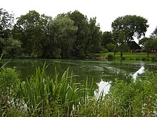
Four Wehlen characterize the immediate landscape at the Porrendeich. These are bodies of water that were created when dykes were breached in the 16th century through deep scouring . These depressions were not refilled after the new dyke was built.
In the east-west direction, the Wehlen have the following names:
- Elliensdeepwehle
- Sandwiches
- Schluppwehle
- Great choice.
The village of Uelvesbüll was a parish with the villages of Barnekermoor, Bös-söwen, Porrendeich, Westerdeich, Norderfriedrichskoog and Schiedhörn (as of 1710).
history
Second Marcellus flood
Before the second Marcellus flood in 1362, the old town of Uelvesbüll, which sank during this storm surge, belonged to the Edomsharde from the Strand . Many of the houses and farms at that time were located further north and west in today's mudflats. The district of Barneckermoor was originally an independent parish and had its own church. At that time Barneckermoor was already part of the Everschop Harde . Later Barneckermoor was merged with the parish of Uelvesbüll.
As a result of the enlargement of the Hever , the new place Uelvesbüll had to be relocated to the southern area. After the flood, which also destroyed the first church, Uelvesbüll was then part of the Harde Everschop.
St. Nikolai Church
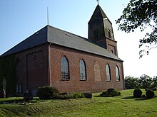
The second church, built after the flood, had to be demolished in 1854 due to its dilapidation. The Protestant St. Nikolai Church, surrounded by the cemetery, was erected in the style of a classicist-neo-Gothic brick building within six months and was inaugurated on October 6, 1854. Because the Danish King Friedrich VII had granted a building subsidy, the church was called Friedrichkirche from 1854 to 1964. In the church building there is a wood-carved epitaph from 1591, which went down in art history as the Volkmarsche epitaph . On October 3, 1867, the parish elected the young theologian Christian Jensen (1839–1900) as its pastor. In 1873 Jensen went to Breklum and in 1876 founded the Schleswig-Holstein Evangelical Lutheran Mission Society .
The only preserved and playable pneumatic organ in Eiderstedt is in the church - built in 1910 by the Apenrad-based organ building company Marcussen & Søn .
Uelvesbüller wreck
During sluice construction work in Uelvesbüller Koog, the wreck of a flat-bottomed, smooth-sided cargo ship was found in July 1994 . The dendrochronological examination of the oak wood revealed that the keel was laid around 1600. About twenty years later there was an accident off the Adolfskoog : the freighter sank into a tidal channel. After the salvage and a two-year stabilization phase in a sugar solution, the wreck has been on display in the Nordfriesland Maritime Museum since April 1998 .
politics
Community representation
According to the result of the municipal elections on May 6, 2018, there was an even distribution of seats in the municipal council for the electoral period until 2023. Both the CDU and the two voter communities KWUe and WVUe each received three seats. The turnout this time was 77.7 percent.
In the local elections on May 26, 2013, the SPD received 24.7 percent and two seats. The CDU also had two seats with 22.5 percent. The WVUe also achieved two seats with 19.5 percent. Three seats went to the new municipal electoral community Uelvesbüll (KWUe), which reached 33.4 percent. The turnout was 77.2 percent.
Of the nine seats in the municipal council, the CDU , the SPD and the WVUe electoral community each had three seats since the 2008 local elections.
mayor
Holger Suckow (WVUe) was elected mayor for the 2018–2023 election period. He is replacing Christel Zumach (SPD), who was mayor in the two previous election periods.
coat of arms
Blazon : "Under a curved, golden shield head of green and blue divided by two narrow silver wavy bars, above a silver ox head, accompanied on the right and left by a golden ear of wheat, below a silver crab-catching net (Porrenglieb)"
Attractions
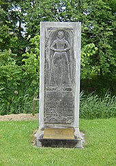
In the list of cultural monuments in Uelvesbüll are the cultural monuments entered in the monuments list of the state of Schleswig-Holstein. This also includes the gravestone Margareta Hans († December 25, 1614) in front of the Haubarg Leutnantshof at Porrendeich.
literature
- Helmut Hess: Chronicle of Uelvesbüll. Municipality of Uelvesbüll, Uelvesbüll 1985.
- Hans Joachim Kühn: Stranded near Uelvesbüll. Wreck archeology in North Frisia. Husum Verlag, Husum 1999, ISBN 978-3-88042-917-8 .
- Hans-Walter Wulf: Churches in Eiderstedt. Lühr & Dircks, St. Peter-Ording 1981, ISBN 3-921416-13-2 .
Web links
- Uelvesbüll municipality
- Wester-Spätinge. NABU, accessed June 13, 2012 .
- De Dam was closed between Eyderstede and Husum ... The dike on the 'Nordt Eyder'. (PDF; 425 kB) Dirk Meier, accessed on January 5, 2016 .
Individual evidence
- ↑ North Statistics Office - Population of the municipalities in Schleswig-Holstein 4th quarter 2019 (XLSX file) (update based on the 2011 census) ( help on this ).
- ↑ Eiderstedter Kultursaison e. V. (Ed.): Culture travel guide Eiderstedt. Culture season 2012. Tönning 2012, p. 144.
- ↑ Helmut Hess: Chronicle of Uelvesbüll. Municipality of Uelvesbüll, Uelvesbüll 1985, p. 116.
- ↑ Helmut Hess: Chronicle of Uelvesbüll. Municipality of Uelvesbüll, Uelvesbüll 1985, p. 18.
- ↑ Helmut Hess: Chronicle of Uelvesbüll. Municipality of Uelvesbüll 1985, map around 1250, p. 14.
- ↑ Klaus-Joachim Lorenzen-Schmidt , Ortwin Pelc (Ed.): The new Schleswig-Holstein Lexicon. Wachholtz, Neumünster 2006, Lemma "Jensen, Christian".
- ^ Hans-Walter Wulf: Churches in Eiderstedt. Lühr & Dircks, St. Peter-Ording 1981, pp. 71-74.
- ^ Hans Joachim Kühn: The Frisian cargo sailor in the Husum Maritime Museum. (PDF; 221 kB)
- ↑ Result Uelvesbüll KW 2018. Accessed on July 6, 2019 .
- ^ Result of Uelvesbüll local elections 2013
- ↑ 01st GV Uelvesbüll on June 19, 2018. (pdf) Retrieved July 6, 2019 .
- ↑ Schleswig-Holstein's municipal coat of arms


