
Dagebüll
| coat of arms | Germany map | |
|---|---|---|

|
Coordinates: 54 ° 44 ' N , 8 ° 43' E |
|
| Basic data | ||
| State : | Schleswig-Holstein | |
| Circle : | North Friesland | |
| Office : | Südtondern | |
| Height : | 1 m above sea level NHN | |
| Area : | 36.92 km 2 | |
| Residents: | 884 (Dec. 31, 2019) | |
| Population density : | 24 inhabitants per km 2 | |
| Postal code : | 25899 | |
| Primaries : | 04667, 04674 | |
| License plate : | NF | |
| Community key : | 01 0 54 022 | |
| LOCODE : | DE DAG | |
| Office administration address: | Marktstrasse 12 25899 Niebüll |
|
| Website : | ||
| Mayor : | Kurt Hinrichsen (UWD) | |
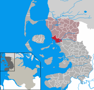
| Location of the municipality of Dagebüll in the district of North Friesland | ||
  |
||


Dagebüll ( Danish Dagebøl , North Frisian Doogebel ) is a municipality located on the west coast of Schleswig-Holstein in the district of North Frisia .
The current layout of the municipality took place in 1978 when the previously independent municipalities Fahretoft , Juliane-Marien-Koog and Waygaard were added . Originally Dagebüll was a Hallig . This history can still be discovered geographically today in the settlement structure. Some settlement areas are on so-called terps . It was not until 1704 that the land was secured with dykes .
geography
Geographical location
Dagebüll is located on the outer edge of the Bökingharde landscape area , one of the so-called Marsch harden of what is now the South Tondern administrative area .
Community structure
The present congregation has grown together over the years from various predecessor congregations. In the 1987 population census in the Federal Republic of Germany , the analysis was carried out using the official Schleswig-Holstein register of places to live in 1987 . According to this, the municipality of Dagebüll consisted of a total of 52 settlements of various shapes. The only village within the municipality was the Süderwaygaard settlement . Even the main places, which have the municipality name in the place name, are still indicated there as a group of houses or house.
Neighboring communities
Dagebüll borders on:
| Galmsbull |
Risum-Lindholm Stedesand |
|
.svg)
|
Longhorn | |
| Ockholm |
geology
The municipality is structured in a variety of ways and today includes the lands of various kays that were diked between 1577 and 1988 . In detail these are (in brackets: years of embankment):
- Waygaarder Koog (1577)
- Bottschlotter Koog (1641)
- Blumenkoog (1652)
- Fahretofter Süderkoog (1688)
- Fahretofter Norderkoog (1690)
- Dagebüller Koog (1704) with the main places Dagebüllkirche and Dagebüll-Hafen
- Juliane-Marienkoog (1778)
- Osewoldter Koog (1936)
- Hauke-Haien-Koog (northern part) (1959)
- Fahretofter Westerkoog (1988)
Based on their age, these kegs can be classified as Kalk or Kleimarschen .
Brief description of the core locations
Dagebüll Church

The district of Dagebüll-Kirche (North Frisian: Doogebel-Schörk ) essentially forms the former Halligland, which was diked at the beginning of the 18th century. Due to the genesis, some terps have been preserved to this day.
The St. Dionysius Church is also on a terp (Söschenswarft) within the old Hallig. it was built in 1731 without a church tower. When a tower building fund was available in 1905/06 , it was decided to build the tower at a later date.
Dagebull harbor

The district of Dagebüll-Hafen is located about three kilometers west of Dagebüll-Kirche directly on the state protection dike. The ferries to the islands of Föhr and Amrum leave from the mole adjoining the outer dyke with its harbor basin . Today there are numerous tourist businesses here as well as the spacious so-called island car park for travelers on the ferry lines to the north .
The Dagebüll lighthouse is located south of the ferry port. Today it has no function as a navigation mark. Not far from the lighthouse on the edge of the village is the service yard of the State Office for Coastal Protection, National Park and Marine Protection Schleswig-Holstein , whose Halligbahn Dagebüll – Oland – Langeneß starts its 900 mm wide railroad on pile yokes through the Watt to Oland and Langeness .
Osewoldter Koog
The Osewoldter Koog was diked in 1935 and settled in 1936.
Drive often
The Fahretoft district has developed along the dike line of the so-called Dutch dike . This is where the community's sports club, TSV Fahretoft / Waygaard, which was founded in 1965, has its headquarters. One of the Köge in Fahretoft is the Bottschlotter Koog . This was diked between 1633 and 1638 and is named after the deep of the same name. In this Koog there are a total of nine properties and around 28 residents who live mainly from agriculture.
history
The Dagebüller Land was formerly a Hallig called Westermarsch . In 1626 it was 895 demat in size, about 447.5 hectares. In the 16th and 17th centuries attempts were unsuccessful to dike Dagebüller Bay at once. However, it was not possible to contain all the tidal fluxes at the same time, so that floods and land losses repeatedly occurred. Especially in the Burchardi flood of 1634, Hallig , which was only surrounded by a summer dike , suffered major land losses.
In 1700 the residents received an advantageous octroy that enabled them to build a solid dike. The embankment was carried out in 1702 and 1703. The Dagebüller Koog comprised 1005 Demat (502.5 hectares) and shifted the geographical center further east compared to the old Hallig. In 1704 it was connected to the foreland of the old Christian-Albrechts-Koog by a newly built dam .
Due to the Kleiseerkoog , which was diked in 1727 , the Dagebüller Koog finally became land-based.
Incorporations
On January 1, 1978, the previously independent communities Fahretoft, Juliane-Marienkoog and Waygaard were incorporated.
religion

The two Evangelical Lutheran parishes of Fahretoft (with Waygaard) and Dagebüll are combined in one parish office. Each parish has a church, the St. Laurentius Church in Fahretoft, which was built in 1703, and the St. Dionysius Church in Dagebüll, built in 1731 .
politics
Community representation
Of the eleven seats in the municipal council, the Voting Community Independent Voting Community Dagebüll (UWD) and Voting Community Dagebüll-Fahretoft-Waygaard (WG-DFW) have each had four seats since the local elections in 2018, the CDU has two seats and the Voting Association Citizens for Citizens (FIG ) a seat.
coat of arms
Blazon : “Divided by blue and red by a wide golden oblique left bar, this is covered with three green terps. Above a golden ship's steering wheel, below a golden spade. "
Sports
There are two local sports clubs. TSV Dagebüll-Ockholm from 1965 offers sports such as football, table tennis, badminton, volleyball, aerobics and gymnastics, while SV Dagebüll from 1967 offers gymnastics, horse riding, cycling, Nordic walking, kite surfing, archery and tennis.
Economy and Infrastructure
education
In the Fahretoft district there was an elementary school with the Hans Momsen School from 1963 to 2009 . Since it was closed, the children have attended the elementary school in Risum-Lindholm .
traffic


shipping
The ferry port offers a regular ship connection to the islands of Föhr and Amrum. Small cargo ships, mussel cutters and other ships also operate here.
train
Dagebüll is on the Niebüll – Dagebüll line, which is operated and operated by the North German Railway Company Niebüll mbH . There is a through car system with rail vehicles from DB Fernverkehr , which are decoupled from the intercity connections to Westerland in Niebüll and go to Dagebüll station. The end of the line is Dagebüll Mole (North Frisian: Doogebel Bru ), outside the dike in the port area directly at the ferry docks to Föhr and Amrum. The regular train stop is also the Dagebüll Church station (North Frisian: Doogebel Schörk ). If the port area is flooded, the final stop takes place at the Dagebüll Hafen demand station . This is located inside the dike shortly before the step, which is closed in this case .
A dam with a wagon train connects Dagebüll through the North Frisian Wadden Sea with the Halligen Oland (since 1927) and Langeneß (since 1929), whereby this only serves to transport material for coastal protection and to supply the Halligen, but not for public transport. Initially these carts had a sail and were powered by wind power, later they were given a diesel engine.
Road traffic
Dagebüll is connected to the regional trunk road network by state roads from federal highway 5 . Coming from the south, from Husum and Bredstedt , the Schleswig-Holstein state road 6 branches off at the foot of the Stollberg . This already turns into the L 191 in the through-town of Sterdebüll and leads via Ockholm and Schlüttsiel to Dagebüll.
Coming from the north-east from Niebüll and Risum-Lindholm , drivers can reach the municipality via a network of different national roads.
Car traffic to the islands has been routed north around the center of Dagebüller via a bypass road since around 2005. There are extensive, chargeable parking facilities for motor vehicles on this street. Previously, numerous inner-city meadows had been offered by the landowners as parking spaces for cars.
From Dagebüll-Hafen the state road 9 leads to Dagebüll.
Sons and daughters of the church
- Jes Leve Duysen (1820–1903), piano maker
- Hans Mollenhauer Millies (1883–1957), violinist and composer
- Frederik Paulsen (1909–1997), doctor and entrepreneur
Cultural monuments
literature
- Harry Kunz, Albert Panten : The Köge of North Frisia . Nordfriisk Instituut, Bredstedt 1996, ISBN 3-88007-251-5 .
Web links
Individual evidence
- ↑ North Statistics Office - Population of the municipalities in Schleswig-Holstein 4th quarter 2019 (XLSX file) (update based on the 2011 census) ( help on this ).
- ↑ see Housing Directory Schleswig-Holstein 1987. (PDF) State Statistical Office Schleswig-Holstein, April 1992, pp. 34–35 , accessed on March 24, 2020 .
- ↑ Dagebüll and the surrounding area on www.openstreetmap.org. Retrieved January 28, 2019 .
- ^ As stated in Harry Kunz / Albert Panten : Die Köge Nordfrieslands. 2nd Edition. Verlag Nordfriisk Instituut , Bredstedt, 1992.
- ↑ The lighthouse of Dagebüll
- ↑ So on the map of Johannes Petreus from about 1600, printed: Reimer Hansen (Ed.): Johannes Petreus' († 1603) writings about north beach. Collection of sources of the Society for Schleswig-Holstein History Volume 5; Kiel 1901; attachment
- ^ Federal Statistical Office (ed.): Historical municipality directory for the Federal Republic of Germany. Name, border and key number changes in municipalities, counties and administrative districts from May 27, 1970 to December 31, 1982 . W. Kohlhammer GmbH, Stuttgart / Mainz 1983, ISBN 3-17-003263-1 , p. 183 .
- ↑ Church leaders of the Dagebüller and Fahretofter Church
- ↑ Dagebüll municipal council
- ↑ Schleswig-Holstein's municipal coat of arms
Achtrup | Ahrenshöft | Ahrenviöl | Ahrenviölfeld | Alkersum | Almdorf | Arlewatt | Aventoft | Bargum | Behrendorf | Bohmstedt | Bondelum | Bordelum | Borgsum | Bosbull | Braderup | Bramstedtlund | Bredstedt | Breklum | Dagebüll | Drage | Drelsdorf | Dunsum | Elisabeth-Sophien-Koog | Ellhöft | Emmelsbüll-Horsbüll | Narrow Sands | Fresendelf | Friedrich-Wilhelm-Lübke-Koog | Friedrichstadt | Galmsbüll | Garding | Garding, parish | Goldebek | Goldelund | Gröde | Grothusenkoog | Haselund | Hattstedt | Hattstedtermarsch | Högel | Spar | Hooge | Hörnum (Sylt) | Horstedt | Hude | Humptrup | Husum | Immenstedt | Joldelund | Kampen (Sylt) | Karlum | Katharinenheerd | Klanxbüll | Klixbull | Koldenbüttel | Kolkerheide | Kotzenbüll | Ladelund | Langeneß | Langenhorn | Leak | Lexgaard | List on Sylt | Löwenstedt | Lütjenholm | Midlum | Mildstedt | Fog | Neukirchen | Nieblum | Niebüll | Norddorf on Amrum | Norderfriedrichskoog | North beach | Norstedt | Ockholm | Oevenum | Oldenswort | Oldersbek | Olderup | Oldsum | Ostenfeld (Husum) | Oster-Ohrstedt | Osterhever | Pellworm | Poppenbüll | Ramstedt | Rantrum | Reußenköge | Risum-Lindholm | Rodenäs | Sankt Peter-Ording | Schwabstedt | Schwesing | Seeth | Simonsberg | Sollwitt | Sönnebüll | Sprakebull | Stadum | Stedesand | Struckum | South end | Süderhöft | Süderlügum | South March | Sylt | Tating | Tetenbull | Tinningstedt | Tönning | Tümlauer-Koog | Uelvesbüll | Uphusum | Utersum | Viöl | Vollerwiek | Vollstedt | World | Wenningstedt-Braderup (Sylt) | Wester-Ohrstedt | Westerhever | Westre | Winnert | Wipe | Witsum | Wittbek | Wittdün on Amrum | Joke word | Wobbenbüll | Wrixum | Wyk on Föhr