
Lexgaard
| coat of arms | Germany map | |
|---|---|---|

|
Coordinates: 54 ° 50 ′ N , 8 ° 57 ′ E |
|
| Basic data | ||
| State : | Schleswig-Holstein | |
| Circle : | North Friesland | |
| Office : | Südtondern | |
| Height : | 9 m above sea level NHN | |
| Area : | 5.24 km 2 | |
| Residents: | 52 (Dec. 31, 2019) | |
| Population density : | 10 inhabitants per km 2 | |
| Postal code : | 25923 | |
| Area code : | 04663 | |
| License plate : | NF | |
| Community key : | 01 0 54 077 | |
| Office administration address: | Marktstrasse 12 25899 Niebüll |
|
| Website : | ||
| Mayor : | Sandra Lorenzen | |
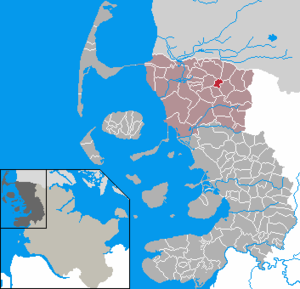
| Location of the community Lexgaard in the district of North Friesland | ||
  |
||

Lexgaard ( Danish : Læksgaarde, Frisian : Leeksguurd) is a municipality in the district of North Friesland in Schleswig-Holstein . Remp is in the municipality.
Geography and traffic
The municipality is located near the Danish border east of federal highway 5 , the Green Coastal Road , on the border between Geest and Marsch . The next train station is in Süderlügum .
politics
Community representation
Due to the decline in the number of residents, there has been a community meeting since the 2008 local elections according to Section 54 of the Schleswig-Holstein municipal code. All residents of the municipality who are entitled to vote belong to it.
mayor
At the municipal assembly on June 10, 2013, Gerhard Hoffmann was re-elected mayor for the 2013-2018 electoral term.
Web links
Individual evidence
- ↑ North Statistics Office - Population of the municipalities in Schleswig-Holstein 4th quarter 2019 (XLSX file) (update based on the 2011 census) ( help on this ).
- ↑ Schleswig-Holstein topography. Vol. 6: Kronprinzenkoog - Mühlenrade . 1st edition Flying-Kiwi-Verl. Junge, Flensburg 2006, ISBN 978-3-926055-85-9 , pp. 151 ( dnb.de [accessed July 25, 2020]).
Achtrup | Ahrenshöft | Ahrenviöl | Ahrenviölfeld | Alkersum | Almdorf | Arlewatt | Aventoft | Bargum | Behrendorf | Bohmstedt | Bondelum | Bordelum | Borgsum | Bosbull | Braderup | Bramstedtlund | Bredstedt | Breklum | Dagebüll | Drage | Drelsdorf | Dunsum | Elisabeth-Sophien-Koog | Ellhöft | Emmelsbüll-Horsbüll | Narrow Sands | Fresendelf | Friedrich-Wilhelm-Lübke-Koog | Friedrichstadt | Galmsbüll | Garding | Garding, parish | Goldebek | Goldelund | Gröde | Grothusenkoog | Haselund | Hattstedt | Hattstedtermarsch | Högel | Spar | Hooge | Hörnum (Sylt) | Horstedt | Hude | Humptrup | Husum | Immenstedt | Joldelund | Kampen (Sylt) | Karlum | Katharinenheerd | Klanxbüll | Klixbull | Koldenbüttel | Kolkerheide | Kotzenbüll | Ladelund | Langeneß | Langenhorn | Leak | Lexgaard | List on Sylt | Löwenstedt | Lütjenholm | Midlum | Mildstedt | Fog | Neukirchen | Nieblum | Niebüll | Norddorf on Amrum | Norderfriedrichskoog | North beach | Norstedt | Ockholm | Oevenum | Oldenswort | Oldersbek | Olderup | Oldsum | Ostenfeld (Husum) | Oster-Ohrstedt | Osterhever | Pellworm | Poppenbüll | Ramstedt | Rantrum | Reußenköge | Risum-Lindholm | Rodenäs | Sankt Peter-Ording | Schwabstedt | Schwesing | Seeth | Simonsberg | Sollwitt | Sönnebüll | Sprakebull | Stadum | Stedesand | Struckum | South end | Süderhöft | Süderlügum | South March | Sylt | Tating | Tetenbull | Tinningstedt | Tönning | Tümlauer-Koog | Uelvesbüll | Uphusum | Utersum | Viöl | Vollerwiek | Vollstedt | World | Wenningstedt-Braderup (Sylt) | Wester-Ohrstedt | Westerhever | Westre | Winnert | Wipe | Witsum | Wittbek | Wittdün on Amrum | Joke word | Wobbenbüll | Wrixum | Wyk on Föhr