
Ahrenshöft
| coat of arms | Germany map | |
|---|---|---|

|
Coordinates: 54 ° 34 ' N , 9 ° 4' E |
|
| Basic data | ||
| State : | Schleswig-Holstein | |
| Circle : | North Friesland | |
| Office : | Central North Friesland | |
| Height : | 4 m above sea level NHN | |
| Area : | 8.79 km 2 | |
| Residents: | 515 (Dec. 31, 2019) | |
| Population density : | 59 inhabitants per km 2 | |
| Postal code : | 25853 | |
| Area code : | 04846 | |
| License plate : | NF | |
| Community key : | 01 0 54 002 | |
| LOCODE : | DE ASH | |
| Office administration address: | Theodor-Storm-Strasse 2 25821 Bredstedt, Germany |
|
| Website : | ||
| Mayor : | Manfred Peters (WGB) | |
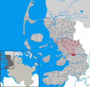
| Location of the municipality of Ahrenshöft in the district of North Friesland | ||
  |
||

Ahrenshöft ( Danish : Ar (e) nshoved or Arnshøft , North Frisian : Oornshaud , Low German : Aarnshöft ) is a municipality in the district of North Friesland , in north-west Schleswig-Holstein .
geography
Geographical location
Ahrenshöft is located on the edge of the large landscape area Schleswigsche Geest in the area of the Nordergoesharde . The southern and western boundary of the municipality is determined by the course of the Arlau river , which enters the landscape of the North Frisian March with its sub-area of the so-called Hattstedtermarsch near the village . The northern municipal boundary runs along the so-called Ahrenshöfter trench .
Community structure
In addition to the eponymous main town, which is divided into the suburbs Groß- and Klein Ahrenshöft, there are also the following officially registered additional settlements in the municipality:
- Eiberg (Danish Ægbjerg )
- Jägerkrug (Danish Jægerkro , North Fr. Jäägerkrooch )
- Steinberg
Neighboring communities
Neighboring communities of Ahrenshöft are:
| Bohmstedt | Norstedt | |
| Hattstedtermarsch |
.svg)
|
Viöl |
| Arlewatt |
geology
The municipal area is structurally clearly characterized by the proportionate location on the Hohe Geest , an old moraine landscape . The soil structures to be found here consist of sediments the grain size of sand . Gravel was quarried early on in the municipality, so that several gravel pits have emerged over time. Some of them have since been renatured. Others were used in the second half of the 20th century to set up the central garbage dump of the district of North Friesland, which is located in the eastern part of the municipality.
The so-called Ahrenshöfter march in the West, however, is a predominantly agriculturally coined landscape area . But it also serves to channel the Geest waters from the hinterland of the Upper and Middle Arlau. Most of the watercourses in the marshland are dammed by dykes .
climate
Ahrenshöft is located in a moderately warm climate zone. Due to its location close to the coast, there is an above-average amount of rainfall during the year. Based on the Köppen-Geiger climate classification , Ahrenshöft is assigned to the "Cfb" class. The annual average temperature is 8.2 ° C. The average annual rainfall is 823 mm.
history
The place was first mentioned in 1455 as Vrenshoude . He goes to dan. hoved for head, projection and the nickname Orne back, which in turn is associated with the animal name Eber . Also possible is a derivative of Adler (Old Norse. Ari , mdän. Arn , neudän. Ørn . See Old Norse. Arnhofði for Adlerkopfiger). The place is historically in the parish of Drelsdorf (Danish Trelstrup Sogn ) within the Nordergoesharde . On April 1, 1934, the parish state municipality Drelsdorf was dissolved. All of their village communities, village communities and farmers became independent communities / rural communities, including Ahrenshöft.
archeology
The Upper Paleolithic Hamburg culture (13,500 to 11,100 BC ) was discovered in northern Germany with the Havelte group (from 13,000 BC). The main bearers of this culture were reindeer hunters . The 12,030 B.C. The Upper Palaeolithic settlement (today Ahrenshöft ) dated to the 3rd century BC belongs to the Havelte group.
politics
Community representation
In the local elections on May 26, 2013, Voting Community A (WGA) received 36.5 percent of the votes and three seats. The voter community B (WGB) came to 63.5 percent and six seats. The turnout was 63.1 percent.
The results of the local elections on May 6, 2018 resulted in the same distribution of seats.
mayor
Manfred Peters (WGB) was re-elected mayor for the 2013-2018 election period.
Economy and Infrastructure
Economic structure
The local economic structure in Ahrenshöft is rural, fragmented. The most well-known companies in the region are likely to be the district's waste management company and the local country inn Dörpskrog Ahrenshöft .
To target the tourist market performs a cycle tourism experience route, called Söbenbargenroute , through the territory of neighboring villages Geest. The basis for the choice of name is the accumulation of a large number of historical burial mounds and other archaeological finds in this area, which indicate an early settlement of the area. The start and finish of the circular route are in the neighboring municipality of Bohmstedt.
traffic
Ahrenshöft is mainly reached by motorized private transport . The place is off the main traffic axis of North Friesland, the federal highway 5 . This runs through the neighboring municipality of Hattstedtermarsch at a distance of about three kilometers from northwest to southeast.
The approach to Ahrenshöft is via the country road 273 via Horstedt and Arlewatt, which connects to the Husum bypass (exit: Drelsdorf) . This route shows the current course of the former Western Ox Trail , a historical trade route across the Schleswig Geest . North Frisian county road 6 crosses north of the Arlau crossing. This crosses the entire municipality. The village is on the left from the crossroads.
In public transport Ahrenshöft is by means of the bus line 1031 (Husum - Bredstedt - Drelsdorf) of the transport composite Schleswig-Holstein connected. This line connects the place to the rail traffic on the march track . The train station in Husum has local and long-distance connections .
The municipal area is also developed through independent bicycle traffic facilities. The main route of the regional cycling network North Friesland runs alongside the road connection of the L 273 via Horstedt and Arlewatt.
Personalities
The actor, director, artistic director, copywriter and pop singer Volker Lechtenbrink (* 1944) lives in Ahrenshöft.

Dörpskrog in Ahrenshöft

Former central garbage dump in the district of North Friesland

Oblique aerial view of the landfill and the adjoining landscape of the northern neighboring communities

Old bakery. The bakery, which was renovated in 2013, is now used as the club house of the Wild League Ahrenshöft.

.JPG)

Web links
Individual evidence
- ↑ North Statistics Office - Population of the municipalities in Schleswig-Holstein 4th quarter 2019 (XLSX file) (update based on the 2011 census) ( help on this ).
- ^ Housing directory Schleswig-Holstein 1987. (pdf) State Statistical Office Schleswig-Holstein, accessed on February 3, 2019 .
- ^ Ahrenshöft climate. Retrieved February 8, 2019 .
- ↑ Wolfgang Laur: Historisches Ortsnamelexikon von Schleswig-Holstein , 2nd edition, Neumünster 1992, p. 117
- ↑ Johannes Kok: Det danske folkesprog i Sønderjylland , Volume 2, København 1867, p. 70
- ↑ State Statistical Office Schleswig-Holstein (Ed.): The population of the communities in Schleswig-Holstein 1867-1970 . State Statistical Office Schleswig-Holstein, Kiel 1972, p. 251 .
- ↑ Result of municipal election Ahrenshöft 2013. ( Page no longer available , search in web archives ) Info: The link was automatically marked as defective. Please check the link according to the instructions and then remove this notice. on the website Amt Mittleres Nordfriesland
- ↑ Announcement of the municipal election results in the municipality of Ahrenshöft. Retrieved January 15, 2018 .
- ↑ “Söbenbargen Route” cycle tour. Retrieved February 20, 2019 .
Achtrup | Ahrenshöft | Ahrenviöl | Ahrenviölfeld | Alkersum | Almdorf | Arlewatt | Aventoft | Bargum | Behrendorf | Bohmstedt | Bondelum | Bordelum | Borgsum | Bosbull | Braderup | Bramstedtlund | Bredstedt | Breklum | Dagebüll | Drage | Drelsdorf | Dunsum | Elisabeth-Sophien-Koog | Ellhöft | Emmelsbüll-Horsbüll | Narrow Sands | Fresendelf | Friedrich-Wilhelm-Lübke-Koog | Friedrichstadt | Galmsbüll | Garding | Garding, parish | Goldebek | Goldelund | Gröde | Grothusenkoog | Haselund | Hattstedt | Hattstedtermarsch | Högel | Spar | Hooge | Hörnum (Sylt) | Horstedt | Hude | Humptrup | Husum | Immenstedt | Joldelund | Kampen (Sylt) | Karlum | Katharinenheerd | Klanxbüll | Klixbull | Koldenbüttel | Kolkerheide | Kotzenbüll | Ladelund | Langeneß | Langenhorn | Leak | Lexgaard | List on Sylt | Löwenstedt | Lütjenholm | Midlum | Mildstedt | Fog | Neukirchen | Nieblum | Niebüll | Norddorf on Amrum | Norderfriedrichskoog | North beach | Norstedt | Ockholm | Oevenum | Oldenswort | Oldersbek | Olderup | Oldsum | Ostenfeld (Husum) | Oster-Ohrstedt | Osterhever | Pellworm | Poppenbüll | Ramstedt | Rantrum | Reußenköge | Risum-Lindholm | Rodenäs | Sankt Peter-Ording | Schwabstedt | Schwesing | Seeth | Simonsberg | Sollwitt | Sönnebüll | Sprakebull | Stadum | Stedesand | Struckum | South end | Süderhöft | Süderlügum | South March | Sylt | Tating | Tetenbull | Tinningstedt | Tönning | Tümlauer-Koog | Uelvesbüll | Uphusum | Utersum | Viöl | Vollerwiek | Vollstedt | World | Wenningstedt-Braderup (Sylt) | Wester-Ohrstedt | Westerhever | Westre | Winnert | Wipe | Witsum | Wittbek | Wittdün on Amrum | Joke word | Wobbenbüll | Wrixum | Wyk on Föhr