
Koldenbüttel
| coat of arms | Germany map | |
|---|---|---|

|
Coordinates: 54 ° 23 ' N , 9 ° 4' E |
|
| Basic data | ||
| State : | Schleswig-Holstein | |
| Circle : | North Friesland | |
| Office : | North Sea Treene | |
| Height : | 2 m above sea level NHN | |
| Area : | 25.8 km 2 | |
| Residents: | 898 (Dec. 31, 2019) | |
| Population density : | 35 inhabitants per km 2 | |
| Postal code : | 25840 | |
| Area code : | 04881 | |
| License plate : | NF | |
| Community key : | 01 0 54 070 | |
| Office administration address: | Schulweg 19 25866 Mildstedt |
|
| Website : | ||
| Mayor : | Detlef Honnens (WGK) | |
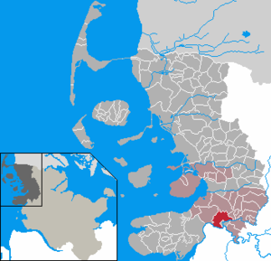
| Location of the municipality of Koldenbüttel in the district of North Friesland | ||
  |
||

Koldenbüttel ( North Frisian : Koolnbütel , Low German : Kombüddel , Danish : Koldenbyttel ) is a municipality in the district of North Friesland in Schleswig-Holstein . Büttel, Herrnhallig, Norddeich and Süderdeich are in the municipality.
geography
Geographical location

The municipal area of Koldenbüttel extends north and west of the lower Treenelauf opposite Friedrichstadt at the transition from the river low to the Eiderstedter Marsch . The adjacent areas along the southern and western municipality Eider today diked areas, among others, the Büttel- , Freesen- and Schwenkenkoogs , the northeastern belong to Herrenhallig . The original, natural course towards the Eider took place along today's Saxfährer Sielzug further west of Friedrichstadt. Koldenbüttel is considered to be the easternmost municipality on the Eiderstedt peninsula .
geology
The community is located in the eastern landscape of the Eiderstedter Marsch and parts of the Eider-Treene lowlands of the Schleswig Geest . Up to the damming of the trees in 1570, the municipality was also exposed to storm surges from the North Sea due to the rising tide levels from the North Sea.
traffic

The federal road 202 runs through the south-western municipality on the southern edge of the eponymous village through the municipality. In the district of Bütteleck it joins a few kilometers with the federal highway 5 coming from Husum to Tönning . While from there the B 202 continues in a westerly direction to St. Peter-Ording , the B 5 crosses the Eider in a southerly direction towards Heide i. H. In an easterly direction, the B 202 connects Koldenbüttel to Fockbek , where it briefly joins the federal highway 203 and finally merges into the federal motorway 210 in the neighboring town of Rendsburg after crossing the Rendsburg Canal Tunnel .
In public transport , the place was connected to the early Danish railway network from 1854 on the Flensburg – Husum – Tönning railway with its Büttel stop in the western municipal area. After the construction of the Marschbahn , which was finally extended beyond Friedrichstadt in 1887, the situation improved suddenly, as the new Reichsbahnhof in Friedrichstadt is directly adjacent to the village of Koldenbüttel. The original Büttel stop was finally abandoned.
The road connection running along the western Treene dam, parallel to the Marschbahn, enables direct access to the Friedrichstadt train station and the neighboring city. This ends directly to the west at the level crossing of the B 202 in Friedrichstadt.
history
Koldenbüttel goes back to an older settlement / hometown “ -büttel ”, which was abandoned at the time of the Great Migration and settled again 1000 to 1200 years ago. The place name accordingly also means "cold (in the sense of cold, extinct) settlement".
The St. Leonhard Church was built around 1200 by Frisian immigrants who settled in Eiderstedt around 1100. In pre-Christian times there was a holy spring in the same place. The place first appeared in a document in 1352. The single standing church tower made of wood ( bell stack ) in Koldenbüttel is the oldest of its kind in Schleswig-Holstein. The wood from which it was built was verifiably felled around 1461. The pastorate was built in 1658.
With the incorporation of Schleswig-Holstein into the Prussian administration as the province of Schleswig-Holstein , Koldenbüttel came to the Eiderstedt district in 1867 and formed its own administrative district from 1889, and its own office from 1948. Since April 26, 1970 Koldenbüttel belongs to the district of North Friesland . The place was initially incorporated into the Friedrichstadt office. After its dissolution in 2008, he was part of the Nordsee-Treene office .
Outsourcing
On January 1, 1974, an area with then around 30 inhabitants was assigned to Friedrichstadt.
politics
Community representation
In the municipal council election carried out as part of the local elections in Schleswig-Holstein in 2018 , the candidates nominated by the KWV voter community achieved a vote of 66.1 percent, while the SPD applicants received 33.9 percent. This results in a distribution of seats of 7 to 4 in the current term of office (2018–2023). No other candidates stood in the election. The turnout was 59.7 percent.
mayor
At the constituent meeting of the municipal council, Detlef Honnens (WGK) was re-elected mayor for the 2018–2023 election period. He already held the office in the previous electoral term from 2013-2018.
coat of arms
Blazon : "Under a green corrugated shield head, inside a horizontal broken golden chain, in silver two narrow blue wavy bars over a blue three-pointed pinnacle shield base, inside a narrow silver wavy bar."
Cityscape and culture
The Kirchdorf Koldenbüttel is surrounded by numerous farms and smaller cottages surrounded engaged in various polders often on municipal territory and mounds are. Of the once 35 Haubarg today is still one: the Riesbüllhof. The Schütthof was destroyed by fire in December 2008.
Next to the church is the diaconate. The building, built in 1969, is still crowned by the gable of its predecessor from 1614. The pastorate has been located in the Marschbürgerhaus, built in 1658, since 1754.
Since 1997, the “Koldenbüttler Summer” series of events has been held in the town every year, with concert evenings and art exhibitions.
economy
On both sides of Bundesstraße 202 , several craft businesses and trading companies have settled in two industrial areas that come right up to Friedrichstadt . These include several convenience stores that supply the neighboring Frederick city and the other with Nahregion.
There are extensive housing estates in the municipality, many residents commute to Friedrichstadt, Husum, Tönning or Heide.
Sons and daughters of the church
- Anna Ovena Hoyer (1584–1655), German baroque poet
- Wilhelm Peters (1815–1883), naturalist and zoologist
- Christian Heinrich Friedrich Peters (1813–1890), German-American astronomer
- Friedrich Sass (1883–1968), mechanical engineer and university professor

St. Leonhard Church with the stack of bells next to it
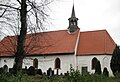
St. Leonhard Church
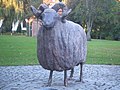
Sculpture by Lothar Frieling, 2001, in front of the St. Leonhard Church


literature
- Martin Becker and Gert Kaster: Eider-Treene-Sorge cultural landscape. Wachholtz, Neumünster 2005, pp. 100-101
Web links
Individual evidence
- ↑ North Statistics Office - Population of the municipalities in Schleswig-Holstein 4th quarter 2019 (XLSX file) (update based on the 2011 census) ( help on this ).
- ↑ Schleswig-Holstein topography. Vol. 5: Holt - Krokau . 1st edition Flying-Kiwi-Verl. Junge, Flensburg 2005, ISBN 978-3-926055-79-8 , pp. 302 ( dnb.de [accessed on July 20, 2020]).
- ↑ also Herrenhallig
- ^ Federal Statistical Office (ed.): Historical municipality directory for the Federal Republic of Germany. Name, border and key number changes in municipalities, counties and administrative districts from May 27, 1970 to December 31, 1982 . W. Kohlhammer GmbH, Stuttgart / Mainz 1983, ISBN 3-17-003263-1 , p. 182 .
- ↑ Election results Koldenbüttel KW 2018 constituency 1. Accessed on June 15, 2020 .
- ↑ Schleswig-Holstein's municipal coat of arms
Achtrup | Ahrenshöft | Ahrenviöl | Ahrenviölfeld | Alkersum | Almdorf | Arlewatt | Aventoft | Bargum | Behrendorf | Bohmstedt | Bondelum | Bordelum | Borgsum | Bosbull | Braderup | Bramstedtlund | Bredstedt | Breklum | Dagebüll | Drage | Drelsdorf | Dunsum | Elisabeth-Sophien-Koog | Ellhöft | Emmelsbüll-Horsbüll | Narrow Sands | Fresendelf | Friedrich-Wilhelm-Lübke-Koog | Friedrichstadt | Galmsbüll | Garding | Garding, parish | Goldebek | Goldelund | Gröde | Grothusenkoog | Haselund | Hattstedt | Hattstedtermarsch | Högel | Spar | Hooge | Hörnum (Sylt) | Horstedt | Hude | Humptrup | Husum | Immenstedt | Joldelund | Kampen (Sylt) | Karlum | Katharinenheerd | Klanxbüll | Klixbull | Koldenbüttel | Kolkerheide | Kotzenbüll | Ladelund | Langeneß | Langenhorn | Leak | Lexgaard | List on Sylt | Löwenstedt | Lütjenholm | Midlum | Mildstedt | Fog | Neukirchen | Nieblum | Niebüll | Norddorf on Amrum | Norderfriedrichskoog | North beach | Norstedt | Ockholm | Oevenum | Oldenswort | Oldersbek | Olderup | Oldsum | Ostenfeld (Husum) | Oster-Ohrstedt | Osterhever | Pellworm | Poppenbüll | Ramstedt | Rantrum | Reußenköge | Risum-Lindholm | Rodenäs | Sankt Peter-Ording | Schwabstedt | Schwesing | Seeth | Simonsberg | Sollwitt | Sönnebüll | Sprakebull | Stadum | Stedesand | Struckum | South end | Süderhöft | Süderlügum | South March | Sylt | Tating | Tetenbull | Tinningstedt | Tönning | Tümlauer-Koog | Uelvesbüll | Uphusum | Utersum | Viöl | Vollerwiek | Vollstedt | World | Wenningstedt-Braderup (Sylt) | Wester-Ohrstedt | Westerhever | Westre | Winnert | Wipe | Witsum | Wittbek | Wittdün on Amrum | Joke word | Wobbenbüll | Wrixum | Wyk on Föhr