
Witsum
| coat of arms | Germany map | |
|---|---|---|

|
Coordinates: 54 ° 42 ' N , 8 ° 26' E |
|
| Basic data | ||
| State : | Schleswig-Holstein | |
| Circle : | North Friesland | |
| Office : | Foehr-Amrum | |
| Height : | 8 m above sea level NHN | |
| Area : | 1.59 km 2 | |
| Residents: | 48 (Dec. 31, 2019) | |
| Population density : | 30 inhabitants per km 2 | |
| Postal code : | 25938 | |
| Area code : | 04683 | |
| License plate : | NF | |
| Community key : | 01 0 54 158 | |
| Office administration address: | Hafenstrasse 23 25938 Wyk auf Föhr |
|
| Website : | ||
| Mayor : | Cornelius Daniels | |
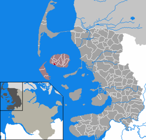
| Location of the municipality of Witsum in the district of North Friesland | ||
  |
||


Witsum ( Danish : Vitsum , Frisian : Wiisem ) is a municipality in the district of North Friesland in Schleswig-Holstein .
geography
Witsum is located in the west of the island of Föhr on the edge of the geest strip that runs roughly along the southern shore of the island above the Godel lowlands .
Within the municipality is the almost eleven meter high Sylvert, one of the highest land areas on the island. For this reason it is said: What Mount Everest is to the whole earth, the Sylvert is to our dear island of Föhr. Due to its location, the Halligen Langeneß and Hooge as well as the island of Amrum can be seen from Witsum on a clear day .
Many species of sea birds breed on the Godel , the only river on the island that flows into the North Sea southeast of the town center between salt marshes . These include migratory birds.
Witsum is one of the smallest communities in Germany in terms of population and area .
history
Witsum is first mentioned in 1509. As part of Westerland Föhr , Witsum belonged to the royal enclaves and belonged directly to the Kingdom of Denmark , while Osterland Föhr and Wyk belonged to the Duchy of Schleswig . Only after Denmark lost Schleswig to Prussia , Witsum also came to Schleswig-Holstein in 1864.
Witsum and the neighboring communities Utersum with today's district Hedehusum were the only communities in Zone II to vote for Denmark in the 1920 referendum ; because they were not directly on the later border, they stayed with Germany.
politics
Community representation
Since the community has fewer than 70 inhabitants, it has a community assembly instead of a community council; this includes all citizens of the community.
mayor
For the 2013-2018 electoral period, the municipal assembly re-elected Cornelius Daniels mayor.
Economy and Infrastructure
Tourism is of central importance for the local economy. A number of holiday homes and apartments are available for holiday guests. This fact has already led to political differences of opinion in the allocation of building land. It was stipulated that a maximum of four plots of land to be developed according to the Schleswig-Holstein state development plan by 2025, and a maximum of one, may be sold to "strangers".
The nearest shops are in the neighboring villages of Utersum and Nieblum . The closest branch of a financial institution is also in the latter municipality.
traffic
The connection to Witsums leads over the North Frisian county road 122. This branches off between Nieblum and the neighboring town of Borgsum from the main southern connection axis on the island, the state road 214. Both roads lead to Utersum.
In public transport the location is regularly served by the two Föhrer bus lines. The two lines are circular traffic in the opposite direction from and to the harbor in Wyk. The journey time from Wyk to Witsum and back is around 45 minutes. The responsible transport company is the Wyker Dampfschiffs-Reederei , which has largely synchronized the bus schedule according to the ferry connections.
gallery
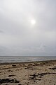
Beach near Witsum with a view towards Amrum
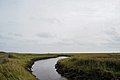
Bach Godel near Witsum looking south-east

Bach Godel near Witsum looking north-west


Web links
Individual evidence
- ↑ North Statistics Office - Population of the municipalities in Schleswig-Holstein 4th quarter 2019 (XLSX file) (update based on the 2011 census) ( help on this ).
Achtrup | Ahrenshöft | Ahrenviöl | Ahrenviölfeld | Alkersum | Almdorf | Arlewatt | Aventoft | Bargum | Behrendorf | Bohmstedt | Bondelum | Bordelum | Borgsum | Bosbull | Braderup | Bramstedtlund | Bredstedt | Breklum | Dagebüll | Drage | Drelsdorf | Dunsum | Elisabeth-Sophien-Koog | Ellhöft | Emmelsbüll-Horsbüll | Narrow Sands | Fresendelf | Friedrich-Wilhelm-Lübke-Koog | Friedrichstadt | Galmsbüll | Garding | Garding, parish | Goldebek | Goldelund | Gröde | Grothusenkoog | Haselund | Hattstedt | Hattstedtermarsch | Högel | Spar | Hooge | Hörnum (Sylt) | Horstedt | Hude | Humptrup | Husum | Immenstedt | Joldelund | Kampen (Sylt) | Karlum | Katharinenheerd | Klanxbüll | Klixbull | Koldenbüttel | Kolkerheide | Kotzenbüll | Ladelund | Langeneß | Langenhorn | Leak | Lexgaard | List on Sylt | Löwenstedt | Lütjenholm | Midlum | Mildstedt | Fog | Neukirchen | Nieblum | Niebüll | Norddorf on Amrum | Norderfriedrichskoog | North beach | Norstedt | Ockholm | Oevenum | Oldenswort | Oldersbek | Olderup | Oldsum | Ostenfeld (Husum) | Oster-Ohrstedt | Osterhever | Pellworm | Poppenbüll | Ramstedt | Rantrum | Reußenköge | Risum-Lindholm | Rodenäs | Sankt Peter-Ording | Schwabstedt | Schwesing | Seeth | Simonsberg | Sollwitt | Sönnebüll | Sprakebull | Stadum | Stedesand | Struckum | South end | Süderhöft | Süderlügum | South March | Sylt | Tating | Tetenbull | Tinningstedt | Tönning | Tümlauer-Koog | Uelvesbüll | Uphusum | Utersum | Viöl | Vollerwiek | Vollstedt | World | Wenningstedt-Braderup (Sylt) | Wester-Ohrstedt | Westerhever | Westre | Winnert | Wipe | Witsum | Wittbek | Wittdün on Amrum | Joke word | Wobbenbüll | Wrixum | Wyk on Föhr