
Friedrich-Wilhelm-Lübke-Koog
| coat of arms | Germany map | |
|---|---|---|

|
Coordinates: 54 ° 52 ' N , 8 ° 38' E |
|
| Basic data | ||
| State : | Schleswig-Holstein | |
| Circle : | North Friesland | |
| Office : | Südtondern | |
| Height : | 1 m above sea level NHN | |
| Area : | 13.49 km 2 | |
| Residents: | 179 (Dec. 31, 2019) | |
| Population density : | 13 inhabitants per km 2 | |
| Postal code : | 25924 | |
| Area code : | 04668 | |
| License plate : | NF | |
| Community key : | 01 0 54 034 | |
| Office administration address: | Marktstrasse 12 25899 Niebüll |
|
| Website : | ||
| Mayor : | Christian Nissen (WGL) | |
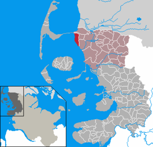
| Location of the community Friedrich-Wilhelm-Lübke-Koog in the district of North Friesland | ||
  |
||

Friedrich-Wilhelm-Lübke-Koog is a municipality in the district of North Friesland in Schleswig-Holstein . The community consists only of the Friedrich-Wilhelm-Lübke-Koog.
geography
The Koog is located south of the Niebüll – Sylt railway on the North Sea .
politics
Community representation
In the local elections on May 26, 2013, the Friedrich-Wilhelm-Lübke-Koog (WGL) community of voters received 72.0 percent of the votes cast and five seats. The CDU reached 28.0 percent and got two seats. The turnout was 61.1 percent.
mayor
In the constituent representative meeting on June 11, 2013, Christian Nissen (WGL) was re-elected mayor for the 2013–2018 electoral term.
history


The Friedrich-Wilhelm-Lübke-Koog was the last Koog in Schleswig-Holstein that was built for land reclamation . Later Köge such as the Hauke-Haien-Koog or the Beltringharder Koog were developed for reasons of coastal protection and are only partially or not at all inhabited.
The embankment of the Koog with an 8.5 kilometer long outer dike was the largest dyke construction project of the post-war period in Schleswig-Holstein. Since numerous refugees and displaced persons settled in Schleswig-Holstein as a result of the Second World War , new settlement areas were to be created as part of the North program . The North program was promoted by the then Minister-President of Schleswig-Holstein, Friedrich Wilhelm Lübke , who is also the namesake.
For the first time a dike was built into what was actually an unprepared Wadden Sea . The up to then usual procedure of dike was done in areas that had been prepared decades in advance and in which land had already partially formed. This dike construction employed around a thousand workers. On 16./17. September 1954 a storm surge destroyed large parts of the dike connection bridge. The water washed away large amounts of building materials. The situation began to become critical, as the dike had to be completed before the autumn and winter storms to avoid even greater damage.
After the dike was closed on October 21, 1954, the land still had to be drained and the infrastructure developed until the first families could settle in 1958/1959. The original settlement consisted of 41 standard farms, a school and an inn with a grocer. Local farmers and displaced persons from the eastern areas were settled in equal shares .
There is no longer a school or kindergarten, but some farms are still run by the families of the first settlers - now in the third generation. Wind energy is an important industry .
economy
Today's image of the Koog is shaped by numerous wind turbines . The community was number one in the German Solar League from 2009 to 2011 .
A wind and heat model region has been set up in Friedrich-Wilhelm-Lübke-Koog since autumn 2018. It was brought into being by the ARGE Netz, the Bürger-Windpark Lübke-Koog Infrastruktur, the municipality Friedrich-Wilhelm-Lübke-Koog and the Institute for Heat and Oil Technology (IWO). It is intended to show how hybrid heating systems with oil condensing boilers and electricity from renewable energy can be used to implement sector coupling on site in an intelligent manner and at comparatively low cost.
Attractions
The cup level in Friedrich-Wilhelm-Lübke-Koog is listed as a technical monument in the list of monuments of Schleswig-Holstein.
literature
- German Border Association (Ed.): Friedrich-Wilhelm-Lübke-Koog . Pressure u. Publishing house, Schleswig 1979.
Web links
Individual evidence
- ↑ North Statistics Office - Population of the municipalities in Schleswig-Holstein 4th quarter 2019 (XLSX file) (update based on the 2011 census) ( help on this ).
- ↑ Schleswig-Holstein topography. Vol. 3: Ellerbek - Groß Rönnau . 1st edition Flying-Kiwi-Verl. Junge, Flensburg 2003, ISBN 978-3-926055-73-6 , p. 170 ( dnb.de [accessed on April 22, 2020]).
- ↑ Web editor: Results of the 2013 municipal elections in the South Tondern office. In: www.amt-suedtondern.de. Office Südtondern, accessed on June 22, 2013 .
- ↑ Solar issues
- ↑ North German energy transition
- ↑ www.Wind-und-Waerme.de
Achtrup | Ahrenshöft | Ahrenviöl | Ahrenviölfeld | Alkersum | Almdorf | Arlewatt | Aventoft | Bargum | Behrendorf | Bohmstedt | Bondelum | Bordelum | Borgsum | Bosbull | Braderup | Bramstedtlund | Bredstedt | Breklum | Dagebüll | Drage | Drelsdorf | Dunsum | Elisabeth-Sophien-Koog | Ellhöft | Emmelsbüll-Horsbüll | Narrow Sands | Fresendelf | Friedrich-Wilhelm-Lübke-Koog | Friedrichstadt | Galmsbüll | Garding | Garding, parish | Goldebek | Goldelund | Gröde | Grothusenkoog | Haselund | Hattstedt | Hattstedtermarsch | Högel | Spar | Hooge | Hörnum (Sylt) | Horstedt | Hude | Humptrup | Husum | Immenstedt | Joldelund | Kampen (Sylt) | Karlum | Katharinenheerd | Klanxbüll | Klixbull | Koldenbüttel | Kolkerheide | Kotzenbüll | Ladelund | Langeneß | Langenhorn | Leak | Lexgaard | List on Sylt | Löwenstedt | Lütjenholm | Midlum | Mildstedt | Fog | Neukirchen | Nieblum | Niebüll | Norddorf on Amrum | Norderfriedrichskoog | North beach | Norstedt | Ockholm | Oevenum | Oldenswort | Oldersbek | Olderup | Oldsum | Ostenfeld (Husum) | Oster-Ohrstedt | Osterhever | Pellworm | Poppenbüll | Ramstedt | Rantrum | Reußenköge | Risum-Lindholm | Rodenäs | Sankt Peter-Ording | Schwabstedt | Schwesing | Seeth | Simonsberg | Sollwitt | Sönnebüll | Sprakebull | Stadum | Stedesand | Struckum | South end | Süderhöft | Süderlügum | South March | Sylt | Tating | Tetenbull | Tinningstedt | Tönning | Tümlauer-Koog | Uelvesbüll | Uphusum | Utersum | Viöl | Vollerwiek | Vollstedt | World | Wenningstedt-Braderup (Sylt) | Wester-Ohrstedt | Westerhever | Westre | Winnert | Wipe | Witsum | Wittbek | Wittdün on Amrum | Joke word | Wobbenbüll | Wrixum | Wyk on Föhr