Karlum
| coat of arms | Germany map | |
|---|---|---|

|
Coordinates: 54 ° 50 ′ N , 8 ° 58 ′ E |
|
| Basic data | ||
| State : | Schleswig-Holstein | |
| Circle : | North Friesland | |
| Office : | Südtondern | |
| Height : | 13 m above sea level NHN | |
| Area : | 14.46 km 2 | |
| Residents: | 212 (Dec. 31, 2019) | |
| Population density : | 15 inhabitants per km 2 | |
| Postal code : | 25926 | |
| Area code : | 04666 | |
| License plate : | NF | |
| Community key : | 01 0 54 062 | |
| Office administration address: | Marktstrasse 12 25899 Niebüll |
|
| Website : | ||
| Mayor : | Werner Richardsen | |
| Location of the municipality of Karlum in the district of North Friesland | ||
Karlum is a municipality in the district of North Friesland in Schleswig-Holstein . Karlumkirche, Gläserkrug, Sterlau and Karlumfeld are in the municipality.
Geography and traffic
Karlum is located about ten kilometers northeast of Niebüll in a rural area near the Danish border. A few kilometers west of the federal highway 5 runs from Niebüll to Tondern in Denmark, south of the federal highway 199 from Niebüll to Flensburg . State road 3 runs through the municipality from Klixbüll to Ladelund .
politics
Community representation
Since the local elections in 2008, a community of voters has all nine seats in the local council. The election on May 26, 2013 had the same result. The last voter turnout was 53.8 percent.
coat of arms
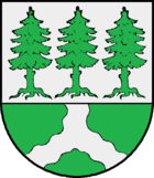
Blazon : “Divided in a ratio of 3: 2 by silver and green. At the top three rooted spruce trees, at the bottom a wavy head in mixed up colors. "
Personalities
- Andreas Hojer (1690–1739), German-Danish historian and legal scholar, was born in Karlum.
- Henrik Georg Clausen (1759-1840), Danish Evangelical Lutheran clergyman, was born in Karlum.
- The farmer and politician (Reichstag member of the DNVP 1924–1928) Peter Bossen (1866–1958) was born in Karlum.
Web links
List of cultural monuments in Karlum
Individual evidence
- ↑ North Statistics Office - Population of the municipalities in Schleswig-Holstein 4th quarter 2019 (XLSX file) (update based on the 2011 census) ( help on this ).
- ↑ Schleswig-Holstein topography. Vol. 5: Holt - Krokau . 1st edition Flying-Kiwi-Verl. Junge, Flensburg 2005, ISBN 978-3-926055-79-8 , pp. 170 ( dnb.de [accessed on July 20, 2020]).
- ↑ Web editor: Results of the 2013 municipal elections in the South Tondern office. In: www.amt-suedtondern.de. Office Südtondern, accessed on June 22, 2013 .
- ↑ Schleswig-Holstein's municipal coat of arms


