Drelsdorf
| coat of arms | Germany map | |
|---|---|---|

|
Coordinates: 54 ° 36 ' N , 9 ° 2' E |
|
| Basic data | ||
| State : | Schleswig-Holstein | |
| Circle : | North Friesland | |
| Office : | Central North Friesland | |
| Height : | 20 m above sea level NHN | |
| Area : | 17.7 km 2 | |
| Residents: | 1255 (Dec. 31, 2019) | |
| Population density : | 71 inhabitants per km 2 | |
| Postal code : | 25853 | |
| Area code : | 04671 | |
| License plate : | NF | |
| Community key : | 01 0 54 024 | |
| LOCODE : | DE 69U | |
| Office administration address: | Theodor-Storm-Strasse 2 25821 Bredstedt, Germany |
|
| Website : | ||
| Mayor : | Tim Friedrichsen (AAWD I) | |
| Location of the municipality of Drelsdorf in the district of North Friesland | ||
Drelsdorf ( Danish : Trelstorp or Trelstrup , North Frisian : Trölstrup , Low German : Drelsdbod , Jutland : Trælstrup ) is a municipality in the district of North Friesland in Schleswig-Holstein .
geography
Geographical location
The municipality of Drelsdorf extends east of Breklum on the Schleswig Geest . The Ostenau , an orographic right-hand tributary of the Arlau, flows through the municipality .
Community structure
The 1987 census in Germany registered the population on the basis of the following list of places to live. Thereafter, Drelsdorf was structured as follows:
In addition to the eponymous capital, the scattered settlements of Drelsdorf-Norderfeld and Drelsdorf-Osterfeld , the Drelsdorf forester's house , as well as the Morgenstern group of houses and the Petersburg mill were located within the municipality.
Osterfeld is separated from the rest of the area by the Ostenau ( Danish : Østerå ) and lies on the edge of the Drelsdorf Forest.
Neighboring communities
Directly border on the municipality of Drelsdorf:
|
Vollstedt Joldelund |
Kolkerheide | |
| Breklum |

|
Norstedt |
|
Struckum Almdorf |
Bohmstedt |
history
Drelsdorf was mentioned for the first time in 1352. As remains of settlement from the Iron Age show, the place is probably older. The reason for this settlement continuity is likely to be the location on Ochsenweg , which ran west of Drelsdorf. The Drelsdkörper Krog was a resting place on the Ochsenweg. The place name roughly means settlement of the unfree and goes back to old north. þræll and old Danish. thræll for unfree, slave, servant and old Danish. thorp for village, settlement . The village name is of Danish origin, as in the other torp name is the ending part to -rup disappeared, including medium and Danish jütländisch Trælstrup . In High German, on the other hand, the form of -dorf has prevailed.
The place was the main town of the parish of the same name (Danish sogn ) within the Nordergoesharde . After the annexation of Schleswig and Holstein by Prussia, a parish land municipality was formed from the area of the parish of Drelsdorf . It comprised the three villages of Ahrenshöft , Bohmstedt and Drelsdorf. On April 1, 1934, the parish rural communities were dissolved and the village communities have since formed independent rural communities.
In 1926 Drelsdorf received a train station and a railway embankment on the Bredstedt – Löwenstedt railway line , both of which still exist today. Through this railway line, the Drelsdorfers could travel directly to Bredstedt and Flensburg. On November 1, 1942, the line was closed again. As late as 1942 - during the Second World War - the tracks were dismantled again and continued to be used in Poltava (Ukraine) due to the war.
politics
Community representation
Of the 13 seats in the municipal council, the constituency AFWD II had eight seats since the 2008 local elections, and the constituency AAWD I five. In the local elections on May 26, 2013, the turnout was 52.6 percent. The AFWD II came to 60.8 percent, the AAWD I received 39.2 percent. The distribution of seats remained unchanged.
In the local elections on May 6, 2018, AAWD I got 7 seats and AFWD II got 6 seats.
(AAWD I = Modified General Voting Community Drelsdorf I, AFWD II = Absolutely Free Voting Community Drelsdorf II)
mayor
Tim Friedrichsen (AAWD I) was elected mayor for the 2018–2023 election period.
coat of arms
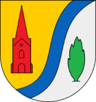
Blazon : “Divided by gold and silver by a lowered blue wavy bar on the left. In front a red church tower, behind a green juniper. "
Attractions
In the list of cultural monuments in Drelsdorf are the cultural monuments entered in the monuments list of the state of Schleswig-Holstein.
St. Mary and St. John Church
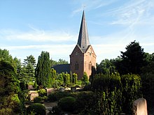
On the western edge of the village is the Romanesque St. Mary and St. John Church from the 12th century. In addition to Drelsdorf, Bohmstedt and Ahrenshöft also belong to the parish . In the church there is also the epitaph with the portrait that inspired Theodor Storm for his well-known novella Aquis submersus . This is partly based on a true story. In 1656 a pastor's son, ten-year-old Heinrich Bonnix, actually drowned. Theodor Storm, however, moved the plot to Hattstedt and turned the guilt of a servant into the guilt of the father.
Pastorate
The thatched-roof pastorate from 1847, which is under monument protection, is located near the church. The pastorate also includes the parish hall, newly built eight years ago, with a senior meeting place, youth wing, nursery and deaconry station.
Drelsdkörper Krog
Also on the western edge of the village is the listed Drelsdäne Krog ( Low German : Krog , inn) from 1909. The Krog was built on the site of a Krog building that was built around 200 years ago and which, due to the carelessness of a beggar roaming the country, was Foundation walls burned down. The Krog was founded by the innkeeper and horse dealer Lorenz Hinrichsen. He had acquired Napoleon Bonaparte's fortune by trading horses with the troops , bought a corner piece of land and built an inn on it. A carved white horse was placed in the gable as a sign of the horse trade. The municipality of Drelsdorf acquired the inn in 1992 and expanded the property with a view to club and village life, as well as to promote tourism.
Eichkratt Schirlbusch nature reserve
The small nature reserve consists of heather and one of the last Eichenkratt . It is around twelve hectares in size and consists of a remnant dune with deposits of drifting sand on top of the Saale-Ice Age bedrock . The Schirlbusch gets its name because of the dense bush forest of low, poor-growing oaks on poor sandy soils. In the protected area there are large windsheared juniper deposits. Furthermore, the area borders on heather areas with rich vegetation (including adder tongue , bearberry and spotted piglet weed ). For centuries this oak forest was used as pasture area (oak mast). The heather, which had been removed along with its roots, also served as litter in the barn.
Drelsdorf Forest
This state forest has a fitness trail and extensive cycling, hiking and riding trails that also lead through the nearby pastures and fields and along the Ostenau.
Drelsdorf poor house
The building was initially used as a farm, shortly before 1800 it became the property of the parish and then became a poor house. Then at the end of the 19th century the poor house burned down. According to various censuses, ten, twelve and even nineteen people lived in this small house with a total size of almost 80 square meters with more than ten rooms. The village chronicle even reports up to 45 people who were housed there. The ceilings of the poorhouse were less than two meters high, the floor was made of clay, the furniture was limited to a few chairs and wall beds, kettles, hymn books and prayer books. At times, people had less than two square meters per person. Because there were no doors in the room, the living space was divided among the families with chalk lines.
In 2003, the Drelsdorf poor house was rebuilt in the Schleswig-Holstein open-air museum in Molfsee to illustrate the topic of poor care and accommodation within the cultural and regional history of Northern Germany . This completes the North Friesland assembly there.
societies
TSV Drelsdorf-Ahrenshöft-Bohmstedt is a popular sports club, which has set itself the goal of offering as many residents of the three villages as possible, as well as those interested in the surrounding communities, fun in sport in the broadest and most up-to-date range possible. The club was founded in 1970 as the successor to TSV Drelsdorf and SV Bohmstedt. The club has almost 900 members and offers sport in 15 different branches. The most important are football, table tennis, athletics and volleyball. The association received a special honor with its program "Games, fun and nutrition for overweight children between eight and twelve years", for which it received the prize "Great Sports Star in Bronze" and 1,500 euros for the association's work.
Economy and Infrastructure
Public facilities
In Drelsdorf, next to the church, there is a Protestant kindergarten, a primary school with an outdoor pool, a fire station with a community room and the mayor's office, a retirement home with twelve residential units and a deaconry of the Protestant church. Until July 2007 there was a branch of the elementary school in Bohmstedt , which was sold to a private person. In 2009, as part of the school reorganization, the main school section in Drelsdorf was closed and the Joldelund elementary school new branch. The facilities are used by the village community of Drelsdorf, Bohmstedt and Ahrenshöft.
traffic
Drelsdorf is located off the federal trunk road network . Due to the location, the Schleswig-Holstein state road 28 runs in the section between the federal road 5 in Bredstedt and the federal road 200 in Viöl . In Drelsdorf it meets the state road 273 . This creates a direct connection in a southerly direction via the Geestdörfer to Husum and today represents the historical route of the Western Ochsenweg .
In public transport , Drelsdorf has been connected to Bredstedt and Flensburg via Joldelund and Lindewitt with the regional bus line R125 of the Schleswig-Holstein local transport network since August 2019 . In addition, the municipality is connected to other municipalities in the surrounding area by a call bus in the Bredstedt call bus area. In addition, the school bus line 1031 provides a direct connection to Husum.
Personalities
- Peter Christian Grünberg (1901–1975), local history researcher, linguist, writer, translator
- Heinke Hannig (* 1957), writer and radio play author, lives in Drelsdorf
Web links
Individual evidence
- ↑ North Statistics Office - Population of the municipalities in Schleswig-Holstein 4th quarter 2019 (XLSX file) (update based on the 2011 census) ( help on this ).
- ^ Housing directory Schleswig-Holstein 1987. Retrieved on November 2, 2019 .
- ↑ Wolfgang Laur: Historisches Ortnamelexikon von Schleswig-Holstein , 2nd edition, Neumünster 1992, p. 220
- ↑ State Statistical Office Schleswig-Holstein (Ed.): The population of the communities in Schleswig-Holstein 1867-1970 . State Statistical Office Schleswig-Holstein, Kiel 1972, p. 251 .
- ↑ Result of the Drelsdorf municipal election 2013. ( Memento of the original from June 10, 2013 in the Internet Archive ) Info: The archive link was automatically inserted and not yet checked. Please check the original and archive link according to the instructions and then remove this notice. on the website Amt Mittleres Nordfriesland
- ↑ Schleswig-Holstein's municipal coat of arms
- ↑ Timetable for bus route R125. Retrieved November 2, 2019 .
- ↑ Flyer on call bus area Bredstedt. Retrieved November 2, 2019 .
- ↑ Timetable for bus route 1031. Retrieved on November 2, 2019 .


