
Katharinenheerd
| coat of arms | Germany map | |
|---|---|---|

|
Coordinates: 54 ° 20 ′ N , 8 ° 50 ′ E |
|
| Basic data | ||
| State : | Schleswig-Holstein | |
| Circle : | North Friesland | |
| Office : | Eiderstedt | |
| Height : | 0 m above sea level NHN | |
| Area : | 8.4 km 2 | |
| Residents: | 175 (Dec. 31, 2019) | |
| Population density : | 21 inhabitants per km 2 | |
| Postal code : | 25836 | |
| Area code : | 04862 | |
| License plate : | NF | |
| Community key : | 01 0 54 063 | |
| Office administration address: | Welter Strasse 1 25836 Garding |
|
| Website : | ||
| Mayor : | Dieter Heisterkamp (CHP) | |
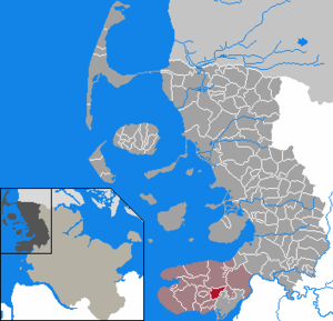
| Location of the community Katharinenheerd in the district of North Friesland | ||
  |
||

Katharinenheerd (Danish: Katrineherd) is a municipality on the Eiderstedt peninsula in the district of North Friesland in Schleswig-Holstein . Allersdorf, Rumpenhof, Hemminghörn and Stolthusen are in the municipality.
geography
Geographical location
The municipality is located in the heart of the Eiderstedt landscape on the west coast of Schleswig-Holstein and extends between the towns of Tönning and Garding. The core area of this march was to the 12th century has a 1.5 meter high summer dike surrounded and grew over time by several embankments successively with the islands Westerheversand and Utholm to its present size together.
Neighboring communities
Katharinenheerd borders on:
| Tetenbull | ||
| Garding parish |
.svg)
|
Kotzenbüll |
| world | Tönning (OT Kating) |
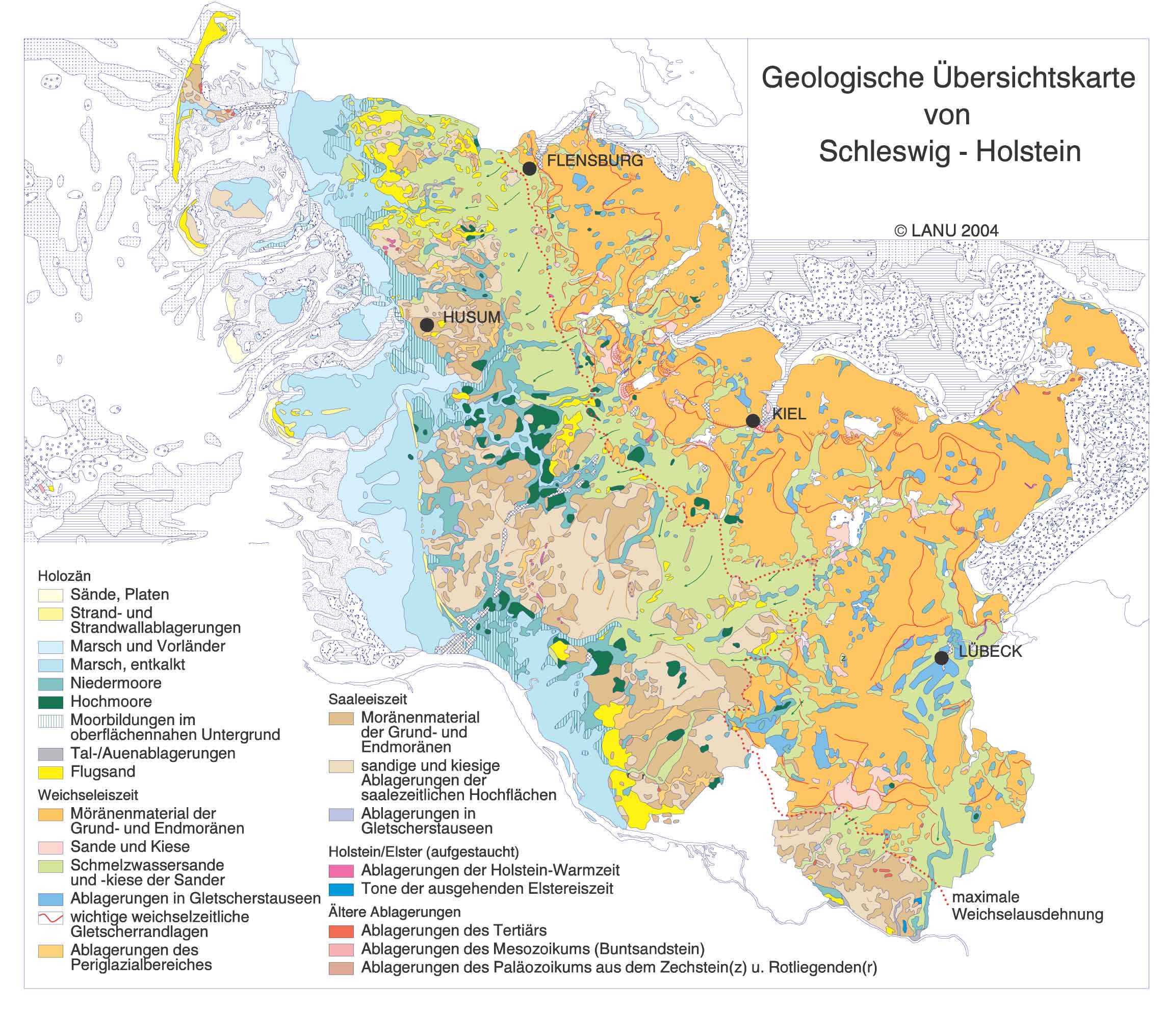
geology
The municipality is located in the Eiderstedter Marsch area . In the municipal area, however, an elongated, sandy beach wall deposit dominates underground. The soil structure has a pseudogley soil with partly sandy grain sizes.
The Norderbootfahrt Canal runs through the municipality to the east on the northern edge. It performs a large part of the hydraulic engineering functions and, as a receiving water , leads the sewage in the direction of Tönning der Eider , partly along federal highway 202 . Drainage takes place through the port of Tönning.
history

The Church of St. Catherine was first mentioned in 1113. Near them was the Dingstätte Hamygenhoren ( Hemminghörn ), where in 1426 the oldesten and klogesten Lüde (the oldest and wisest people) gathered the three lands to discuss the Crown the right truth to adopt. Further arbitrations (legal records) were also discussed and decided here.
In 1612 the Norderbootfahrt , a canal between Tönning and Tetenbüll, was built via Katharinenheerd.
politics

Community representation
In the local elections on May 26, 2013, the KWK electoral community achieved 71.7% of the votes cast and occupied six seats. A single applicant received 17.3% and thus achieved a mandate. The turnout was 76.1 percent.
mayor
Dieter Heisterkamp (KWK) was elected mayor for the 2013–2018 election period. He succeeded Jürgen Sallach, who still belongs to the new municipal council as an individual applicant.
coat of arms
Blazon : "In gold, the standing, barefoot, gold-crowned Saint Catherine with a long red robe and thrown green cloak, in the arms raised to the sides on the right a blue sword, on the left a red wheel."
Economy and Infrastructure
Today tourism and agriculture are the main sources of income for the place. However, there are also retail stores and service providers in the community.
traffic
The place is mainly reached by motorized individual traffic on the federal highway 202 running through the place in the westernmost section between St. Peter-Ording and Tönning.
Katharinenheerd is also on the Husum – Bad St. Peter-Ording railway line . The stop of the same name is located there, where all regional trains on the RB 64 line of the Schleswig-Holstein local transport network stop. The line is single-track.
Attractions
See also: List of cultural monuments in Katharinenheerd
Web links
Individual evidence
- ↑ North Statistics Office - Population of the municipalities in Schleswig-Holstein 4th quarter 2019 (XLSX file) (update based on the 2011 census) ( help on this ).
- ↑ Schleswig-Holstein topography. Vol. 5: Holt - Krokau . 1st edition Flying-Kiwi-Verl. Junge, Flensburg 2005, ISBN 978-3-926055-79-8 , pp. 185 ( dnb.de [accessed on July 20, 2020]).
- ↑ cit. according to Harry Kunz, Albert Panten: Die Köge Nordfrieslands , 2nd edition, Verlag Nordfriisk Instituut , Bredstedt 1999, ISBN 3-88007-251-5 , p. 85.
- ^ Geological overview map of Schleswig-Holstein. Retrieved September 17, 2019 .
- ^ Soil map of Schleswig-Holstein. Retrieved September 17, 2019 .
- ↑ Isabella Löw: The Eiderstedter Landrechte from 1426 to 1591. Legal history, legal change and legal relationships . Nordfriisk Instituut, Bräist / Bredstedt 2003, ISBN 3-88007-301-5 , p. 25.
- ↑ Announcement of the official election results by the Eiderstedt office on May 27, 2013. www.amt-eiderstedt.de/wahlen/2013/Kommunalwahl/katharinenheerd/katharinenheerd.htm
- ↑ Schleswig-Holstein's municipal coat of arms
Achtrup | Ahrenshöft | Ahrenviöl | Ahrenviölfeld | Alkersum | Almdorf | Arlewatt | Aventoft | Bargum | Behrendorf | Bohmstedt | Bondelum | Bordelum | Borgsum | Bosbull | Braderup | Bramstedtlund | Bredstedt | Breklum | Dagebüll | Drage | Drelsdorf | Dunsum | Elisabeth-Sophien-Koog | Ellhöft | Emmelsbüll-Horsbüll | Narrow Sands | Fresendelf | Friedrich-Wilhelm-Lübke-Koog | Friedrichstadt | Galmsbüll | Garding | Garding, parish | Goldebek | Goldelund | Gröde | Grothusenkoog | Haselund | Hattstedt | Hattstedtermarsch | Högel | Spar | Hooge | Hörnum (Sylt) | Horstedt | Hude | Humptrup | Husum | Immenstedt | Joldelund | Kampen (Sylt) | Karlum | Katharinenheerd | Klanxbüll | Klixbull | Koldenbüttel | Kolkerheide | Kotzenbüll | Ladelund | Langeneß | Langenhorn | Leak | Lexgaard | List on Sylt | Löwenstedt | Lütjenholm | Midlum | Mildstedt | Fog | Neukirchen | Nieblum | Niebüll | Norddorf on Amrum | Norderfriedrichskoog | North beach | Norstedt | Ockholm | Oevenum | Oldenswort | Oldersbek | Olderup | Oldsum | Ostenfeld (Husum) | Oster-Ohrstedt | Osterhever | Pellworm | Poppenbüll | Ramstedt | Rantrum | Reußenköge | Risum-Lindholm | Rodenäs | Sankt Peter-Ording | Schwabstedt | Schwesing | Seeth | Simonsberg | Sollwitt | Sönnebüll | Sprakebull | Stadum | Stedesand | Struckum | South end | Süderhöft | Süderlügum | South March | Sylt | Tating | Tetenbull | Tinningstedt | Tönning | Tümlauer-Koog | Uelvesbüll | Uphusum | Utersum | Viöl | Vollerwiek | Vollstedt | World | Wenningstedt-Braderup (Sylt) | Wester-Ohrstedt | Westerhever | Westre | Winnert | Wipe | Witsum | Wittbek | Wittdün on Amrum | Joke word | Wobbenbüll | Wrixum | Wyk on Föhr