
Högel
| coat of arms | Germany map | |
|---|---|---|

|
Coordinates: 54 ° 39 ' N , 9 ° 3' E |
|
| Basic data | ||
| State : | Schleswig-Holstein | |
| Circle : | North Friesland | |
| Office : | Central North Friesland | |
| Height : | 10 m above sea level NHN | |
| Area : | 16.28 km 2 | |
| Residents: | 468 (Dec. 31, 2019) | |
| Population density : | 29 inhabitants per km 2 | |
| Postal code : | 25858 | |
| Area code : | 04673 | |
| License plate : | NF | |
| Community key : | 01 0 54 045 | |
| Office administration address: | Theodor-Storm-Strasse 2 25821 Bredstedt, Germany |
|
| Website : | ||
| Mayor : | Tanja Carstensen (WGH B) | |
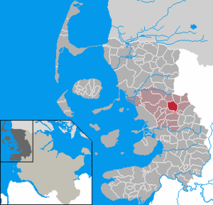
| Location of the municipality Högel in the district of North Friesland | ||
  |
||


Högel ( Danish : Høgel , North Frisian : Höögel ) is a municipality in the district of North Friesland in Schleswig-Holstein .
geography
Geographical location and neighboring communities
Högel is located in the Schleswigschen Geest area about 6 km east of Bredstedt . Neighboring communities are:
| Lütjenholm | Goldelund | |
| Bordelum (OT Dbodum) |
.svg)
|
Joldelund |
| Vollstedt |
Districts
The following districts are located within the municipality:
- Högelfeld
- Hogelund (Danish: Høgellund , only partially)
- Mirebüll (Danish: Mirebøl , North Frisian Mörebel )
history
The place name Högel was first mentioned in 1377 and is derived from the word for hill (cf. old fries . Hugel , old Danish. Hughl ). The name Mirebüll was first mentioned in 1499 and probably means settlement on the Moor zu -büll , Danish. bøl , north fr. bel for settlement and dan. myr for moor.
Until the German-Danish War in 1864 the place belonged to the parish of Breklum ( Breklum Sogn ) within the Nordergoesharde ( Nørre Gøs Herred ) of the Duchy of Schleswig .
From 1923 onwards, the town was supplied with electricity from a jointly set up windmill.
On April 1, 1934, the parish of Breklum was dissolved. All of their villages, village communities and farmers became independent communities / rural communities, including Högel.
politics
Community representation
Of the nine seats in the municipal council, the community of voters WGH B has five seats and the community of voters WGH A four since the 2018 local elections.
Mayoress
Tanja Carstensen (WGH B) was elected mayor for the 2018–2023 election period.
coat of arms
Blazon : "With a golden wedge on the left that is slightly rounded upwards, inside a slightly inclined, lying red rod, divided by green and blue, in the upper left a silver twelve-winged windmill."
Economy and Transport

The community is predominantly agricultural. The generation of renewable energies takes place by means of an open area photovoltaic system and a community wind farm. Local tradespeople are mainly at home in the handicrafts and in the areas upstream and downstream of agriculture. The rental of holiday accommodation is also offered.
The traffic connection takes place via the Schleswig-Holstein state road 12 mainly in motorized individual traffic . In the neighboring sub-center of Bredstedt there is a connection to the federal highway 5 , in the municipality of Wanderup to the federal highway 200 . In the Högelfeld district, a district road branches off from the L 12 towards the neighboring town of Joldelund.
The municipality has been reached by public transport since August 2019 via the neighboring municipality of Joldelund. The R 125 bus of the Schleswig-Holstein local transport network runs from Flensburg to Bredstedt there. The Joldelund on- call bus serves the neighboring communities from Joldelund . There is also a school bus service between Bredstedt and Lindewitt, which leads directly through Högel. In Bredstedt and Flensburg there is a direct connection to the local rail transport in both variants (in Flensburg also long-distance transport ).
Personalities
- Heinke Hannig (* 1957), writer and radio play author, was born in Högel.
- Dörte Hansen (today Dörte Hansen-Jaax; * 1964 in Husum), linguist, journalist and writer, grew up in Högel.
Web links
Individual evidence
- ↑ North Statistics Office - Population of the municipalities in Schleswig-Holstein 4th quarter 2019 (XLSX file) (update based on the 2011 census) ( help on this ).
- ↑ Schleswig-Holstein topography. Vol. 4: Groß Sarau - Holstenniendorf . 1st edition Flying-Kiwi-Verl. Junge, Flensburg 2004, ISBN 978-3-926055-75-0 , p. 295 ( dnb.de [accessed on May 3, 2020]).
- ↑ Schleswig-Holstein topography. Vol. 4: Groß Sarau - Holstenniendorf . 1st edition Flying-Kiwi-Verl. Junge, Flensburg 2004, ISBN 978-3-926055-75-0 , p. 295 ( dnb.de [accessed on May 3, 2020]).
- ↑ Wolfgang Laur: Historisches Ortnamelexikon von Schleswig-Holstein , 2nd edition, Neumünster 1992, p. 333
- ↑ Wolfgang Laur: Historisches Ortsnamelexikon von Schleswig-Holstein , 2nd edition, Neumünster 1992, p. 458
- ↑ State Statistical Office Schleswig-Holstein (Ed.): The population of the communities in Schleswig-Holstein 1867-1970 . State Statistical Office Schleswig-Holstein, Kiel 1972, p. 251 .
- ↑ Announcement of the municipal election results in the municipality of Högel. (pdf) Retrieved September 11, 2018 .
- ↑ Minutes of the constituent meeting of the Högel municipal council on June 19, 2018. (pdf) Retrieved September 11, 2018 .
- ↑ Schleswig-Holstein's municipal coat of arms
- ↑ Timetable for bus route R 125. (pdf) Retrieved on September 19, 2019 .
- ↑ Flyer on the Joldelund on-call bus area. (pdf) Retrieved September 19, 2019 .
Achtrup | Ahrenshöft | Ahrenviöl | Ahrenviölfeld | Alkersum | Almdorf | Arlewatt | Aventoft | Bargum | Behrendorf | Bohmstedt | Bondelum | Bordelum | Borgsum | Bosbull | Braderup | Bramstedtlund | Bredstedt | Breklum | Dagebüll | Drage | Drelsdorf | Dunsum | Elisabeth-Sophien-Koog | Ellhöft | Emmelsbüll-Horsbüll | Narrow Sands | Fresendelf | Friedrich-Wilhelm-Lübke-Koog | Friedrichstadt | Galmsbüll | Garding | Garding, parish | Goldebek | Goldelund | Gröde | Grothusenkoog | Haselund | Hattstedt | Hattstedtermarsch | Högel | Spar | Hooge | Hörnum (Sylt) | Horstedt | Hude | Humptrup | Husum | Immenstedt | Joldelund | Kampen (Sylt) | Karlum | Katharinenheerd | Klanxbüll | Klixbull | Koldenbüttel | Kolkerheide | Kotzenbüll | Ladelund | Langeneß | Langenhorn | Leak | Lexgaard | List on Sylt | Löwenstedt | Lütjenholm | Midlum | Mildstedt | Fog | Neukirchen | Nieblum | Niebüll | Norddorf on Amrum | Norderfriedrichskoog | North beach | Norstedt | Ockholm | Oevenum | Oldenswort | Oldersbek | Olderup | Oldsum | Ostenfeld (Husum) | Oster-Ohrstedt | Osterhever | Pellworm | Poppenbüll | Ramstedt | Rantrum | Reußenköge | Risum-Lindholm | Rodenäs | Sankt Peter-Ording | Schwabstedt | Schwesing | Seeth | Simonsberg | Sollwitt | Sönnebüll | Sprakebull | Stadum | Stedesand | Struckum | South end | Süderhöft | Süderlügum | South March | Sylt | Tating | Tetenbull | Tinningstedt | Tönning | Tümlauer-Koog | Uelvesbüll | Uphusum | Utersum | Viöl | Vollerwiek | Vollstedt | World | Wenningstedt-Braderup (Sylt) | Wester-Ohrstedt | Westerhever | Westre | Winnert | Wipe | Witsum | Wittbek | Wittdün on Amrum | Joke word | Wobbenbüll | Wrixum | Wyk on Föhr