Langeneß (municipality)
| coat of arms | Germany map | |
|---|---|---|

|
Coordinates: 54 ° 38 ' N , 8 ° 37' E |
|
| Basic data | ||
| State : | Schleswig-Holstein | |
| Circle : | North Friesland | |
| Office : | Pellworm | |
| Height : | 1 m above sea level NHN | |
| Area : | 11.57 km 2 | |
| Residents: | 138 (Dec 31, 2019) | |
| Population density : | 12 inhabitants per km 2 | |
| Postcodes : | 25863, 25867 (Oland) |
|
| Area code : | 04684 | |
| License plate : | NF | |
| Community key : | 01 0 54 074 | |
| Address of the municipal administration: |
Uthlandestrasse 1 25849 Pellworm |
|
| Website : | ||
| Mayoress : | Heike Hinrichsen (WGLA) | |
| Location of the municipality of Langeneß (municipality) in the district of North Friesland | ||


Langeneß [ laŋəˈnɛs ] ( Danish Langenæs , North Frisian Nees ) is a municipality in the district of North Friesland in Schleswig-Holstein .
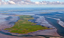
In addition to the Hallig Langeneß , the municipality also includes the Hallig Oland .
Geography and history
Before the Burchardi flood of 1634, the Hallig Langeness, Oland and other land masses formed the Hallig Alt-Langeness.
In 1802, today's Langeneß still consisted of three individual Halligen: Langeneß (east), Butwehl (southeast) and Nordmarsch (west), which grew together up to 1869 through dam construction, lahnungen and natural growth. The original name of the island that has grown together was Nordmarsch-Langeness.
Butwehl may in Waldemars Erdbuch mentioned island Hwäler.
Langeneß became smaller over the centuries. Before the flood of 1825, 70 houses and 187 inhabitants were counted. In 1850 there were 50 houses on 14 terps, and 30 houses in 1905/06. In 1873 the Hallig was 1179 hectares in size. After the survey of 1882 it was only 1025 ha. Today, Langeneß is the largest of the Halligen with a length of about 10 km, a width of up to 1400 m and a total size of 956 ha. The Hallig Oland is about 2.9 km long and up to 980 m wide.
In 1941, the previously independent communities of Nordmarsch (formerly Hallig Nordmarsch), Langeneß (former Halligen Langeneß and Butwehl) and Oland were merged to form a municipality of Langeneß. The administration is located on Pellworm , as the municipality of Langeneß belongs to the Pellworm office and does not have its own administration.
The municipality of Langeneß has 118 inhabitants, 100 of them on Langeneß, who live on 17 terps in 58 households, which are shown in the following table from east to west. The information relates to the last census of May 25, 1987, as population and households are not updated at the residential place level.
 NASA satellite image of Langeneß numbered with terps, Oland at the top right, Gröde at the bottom right , Föhr at the top left |
|||||
 Old postcard with a map of Langeness (ca.1910) |
|||||
|
Living space no. 1 |
Terps | Topographic name |
May 25, 1987 census | ||
|---|---|---|---|---|---|
| population | households | ||||
| Former Hallig Langeneß (east) | |||||
| 1 | Bandix threw | Group of houses | 5 | 3 | 54 ° 38 ′ 50 " N , 8 ° 39 ′ 22" E |
| 10 | Re-thrown | Group of houses | 4th | 2 | 54 ° 38 ′ 23 " N , 8 ° 38 ′ 39" E |
| 12 | Peterhaitzwarf | court | 2 | 1 | |
| 5 | Hunnenswarf | Group of houses | 15th | 7th | |
| 13 | Peterswarf 2 | Group of houses | 1 | 1 | |
| 4th | Honkenswarf | Group of houses | 12 | 4th | |
| 8th | Kirchwarf | church | 4th | 1 | |
| 6th | Ketelswarf | Group of houses | 18th | 9 | |
| Former Hallig Butwehl (south) | |||||
| 16 | Accusation | Group of houses | 6th | 4th | |
| 2 | Christianswarf | Group of houses | 7th | 3 | |
| 17th | Tamenswarf | House | 1 | 1 | |
| Former Hallig Nordmarsch (west) | |||||
| 11 | Norderhörn | Group of houses | 11 | 5 | |
| 18th | Treuberg | Courtyard (uninhabited) | - | - | |
| 15th | Süderhörn | Group of houses | 3 | 2 | |
| 3 | Hilligenley | Group of houses | 9 | 5 | |
| 14th | Rix threw 3 | Group of houses | 5 | 1 | |
| 9 | Mayenswarf | Group of houses | 12 | 5 | |
| 7th | Kirchhofswarf | Group of houses | 4th | 2 | |
| (20) | Halge Huus | (Wooden house) | - | - | |
| (21) | Neupeterswarf 4 | House (destroyed) | - | - | |
| (22) | Old Peterswarf | ( Lighthouse north march ) | - | - | |
| Langeneß | Hallig | 119 | 56 | ||
The largest terp on the Hallig Langeneß is the Ketelswarf, where the tourist office is also located.

politics
Community representation
In the local elections on May 26, 2013 , two voter communities ran . The Voting Community List A (WGLA) received four seats. The Voting Community List B (WGLB) had three seats. From 2008 to 2013, the WGLA had all seven seats in the municipal council.
Mayoress
Heike Hinrichsen (WGLA) was elected mayor for the 2013–2018 election period. She succeeded Hans-Friedrich (called Fiede) Nissen (WGLA), who until then held the office for five years. Heike Hinrichsen was re-elected in 2018.
Web links
Individual evidence
- ↑ North Statistics Office - Population of the municipalities in Schleswig-Holstein 4th quarter 2019 (XLSX file) (update based on the 2011 census) ( help on this ).
- ↑ Population statistics from the North Statistics Office as of December 31, 2011 (PDF file; 423 kB)
- ↑ State Statistical Office Schleswig-Holstein: Housing directory Schleswig-Holstein 1987. Official directory of the offices, municipalities and housing spaces, Kiel 1992, page 38
- ↑ a b A woman at the helm for the first time Husumer Nachrichten dated June 26, 2013, accessed on June 28, 2013


