
Castle (Dithmarschen)
| coat of arms | Germany map | |
|---|---|---|

|
Coordinates: 54 ° 0 ' N , 9 ° 16' E |
|
| Basic data | ||
| State : | Schleswig-Holstein | |
| Circle : | Dithmarschen | |
| Office : | Burg-Sankt Michaelisdonn | |
| Height : | 15 m above sea level NHN | |
| Area : | 11.23 km 2 | |
| Residents: | 4159 (Dec. 31, 2019) | |
| Population density : | 370 inhabitants per km 2 | |
| Postal code : | 25712 | |
| Area code : | 04825 | |
| License plate : | HEI, MED | |
| Community key : | 01 0 51 016 | |
| LOCODE : | DE BRG | |
| Office administration address: | Holzmarkt 7 25712 Burg (Dithmarschen) |
|
| Website : | ||
| Mayoress : | Daniela Niebuhr (Active Castle) | |
| Location of the municipality of Burg (Dithmarschen) in the Dithmarschen district | ||
 |
||

Burg (Dithmarschen) is a municipality in the Dithmarschen district in Schleswig-Holstein .
geography


location
Burg lies on the border of the Dithmarscher Geest and Wilstermarsch and is characterized by two very different natural spaces.
The Geest part is quite hilly and overgrown with forest. The highest point is the Wulffsboom at 65 meters, also known as Hamberg . The Wilstermarsch follows below the Klevhang, which rises up to 35 meters and is an original cliff edge. It is flat, boggy and with little forest and is partly below sea level. The Kiel Canal runs through this natural area in the municipality . Not least because of its special location on the wooded Geest and in the marshland, Burg is often referred to as the "pearl of the west coast of Schleswig-Holstein".
The forest around the castle is partly used by the forest museum. There are two forest-historical plantings and a rock garden with boulders made from ice age debris. On the road On Pape crumpled a rehabilitated is heath with Bronze Age burial mounds . It has been recognized by the Schleswig-Holstein Ministry of the Environment as a natural experience area .
Neighboring communities
Neighboring communities are the communities of Brickeln and Hochdonn (both in the district of Dithmarschen), Gribbohm , Vaale , Bokhorst (exclave) and Abebtissinwisch (all in the district of Steinburg ) and Buchholz (again in the district of Dithmarschen), starting clockwise in the north .
history
On April 1, 1934, the parish of Burg was dissolved. All of their village communities, village communities and farmers became independent communities / rural communities, including their main town, Burg in Dithmarschen.
politics
Community representation
In the local elections in 2018, the following composition of the municipal council came about:
| Party / list | Seats |
| CDU | 7th |
| Active Castle | 6th |
| FDP | 2 |
| SPD | 2 |
coat of arms
The coat of arms and flag were approved on August 26, 1952.
Blazon : "In silver on a golden Dreiberg covered with two blue wavy bars, a two-towered red castle with a closed blue gate, above it two blue keys placed in the cross."
The main character of the municipal coat of arms, the castle, sees itself as a classic "talking" image for the place name. This keeps the memory of the Bökelburg alive, today one of the best preserved ramparts in the Holstein region. Together with other Saxon people's castles, the Bökelburg was built at the beginning of the 9th century at a time when the Saxons were threatened by Franks, Slavs and Danes. The onslaught of the Slavic Abodrites could be stopped here and in Itzehoe in 1033. During the dispute between the Dithmarschers and the Stade Counts, the last Count Rudolf II was allegedly killed in 1144 on the Bökelburg and then destroyed. Perhaps the foundation of the Burger Church, built between 1148 and 1168, goes back to the Count's brother, Archbishop Hartwig von Bremen. It was dedicated to St. Peter, as indicated by the keys in the coat of arms. The template was a parish seal from 1409. The golden Dreiberg indicates the hillside community area on the Geestrand. The wave beams at the foot of the Dreiberg are intended to represent the Burger Au and the Kiel Canal.
The coat of arms was designed by the Brunsbüttel heraldist Willy "Horsa" Lippert .
flag
The flag shows the red castle and the blue keys in the arrangement of the coat of arms in the middle of a white field, each bordered by a narrow blue strip at the top and bottom, free-standing without a shield over 4 white-blue waves, with the beard of the vertical key with its upper part protrudes in a mistaken color into the upper blue stripe.
Public facilities
The municipality is the administrative seat of the office Burg-Sankt Michaelisdonn .
The following general education schools also exist in Burg:
- Primary School Burg, Bahnhofstraße (173 students in 8 classes)
- Community school am Hamberg, Am Sportplatz (406 students in 17 classes)
Student numbers from the school year 2018/2019
Culture and sights
General sights
Burg is officially recognized as a climatic health resort .
In the center of the village is the Baumgarten, the park of the climatic health resort. In addition to rare tree and plant species, the park also has an open-air stage. Concerts and performances are held there regularly in the summer season. Events are held in the Bökelburghalle next door even in bad weather, in particular regional trade fairs and exhibitions.
Burg has a heated forest swimming pool. The outdoor pool has an 80 m long slide, diving towers and a toddler pool.
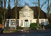
Pharmacy at the market

Driveway to Bökelburg

Krenzerstrasse

Burg station

Cemetery in the Bökelburg

Ferry landing in Burg

Market square in Burg

Baumgarten
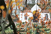
Cemetery chapel in the Bökelburg

amphitheater

Petrikirche
_-_Apotheke.jpg)


Bökelburg, Sage and Petrikirche
The place derives its name from the Bökelburg (Lower German: Buchenburg). This was probably located within the still existing Bökelburg Wall, a ring wall from the 9th century with a diameter of approx. 100 meters. It was erected directly on the Geestrand, from where it allows a wide view of the Wilstermarsch . The castle complex served the Dithmarschers until the 11th century to protect them against Franks , Abodrites and Vikings . Today, a hiking trail has been laid out on the wall; a cemetery has been located inside it since 1818.
According to a legend, Count Rudolf II of Stade resided on the Bökelburg in the 12th century . He ruled the Dithmarscher with a heavy hand and asked after several years of drought the grain tenth . According to Dahlmann, the Dithmarsch farmers managed to get rid of the unloved regent in 1145 with the help of a ruse: Hidden in sacks of grain, some farmers were brought to the castle on a wagon early in the morning. As agreed, they opened the sacks at the sound of the battle cry "Roar de Hann, snidet de Sacksbann!" (Stir your hands, cut the sack volumes). They set the castle on fire, killed the count and his wife Walburga and thus regained their freedom.
.jpg)
This play is performed every five years on the occasion of the Holzmarktfest by local amateur actors in Low German.
In fact, this event is not comprehensible, since neither the course nor the place of the event appear in a contemporary source, but is only mentioned in the Chronicon Holtzatiae of the chronicler Presbyter Bremensis about 300 years after the death of the count . In the Stader and Magdeburg annals it is only said that the deed happened on March 14, 1144 in the tedmarsgoi (Dithmarscher Gau). Rudolf's wife was not called Walburga , but Elisabeth of Styria and did not perish either, but later married Duke Heinrich V of Carinthia .
Already at the end of 1144 Heinrich the Lion declared himself heir to Rudolf II. With Adolf II of Holstein he occupied the country in 1148 and forced the Dithmarschers to pay high tributes .
According to legend, the Burger Petrikirche was built around 1150 to atone for the murder of the regent. The remains of the foundation of the Bökelburg were used for the eastern stone wall.
See also : List of cultural monuments in Burg (Dithmarschen)
Museums

The Burg / Dithmarschen forest museum is part of the Burg nature experience area . The museum is located in a 21-meter-high observation tower on the Wulffsboom that was built in 1914, making it one of the highest points in Dithmarschen. The mouth of the Elbe can be seen from there. The museum is primarily dedicated to the local flora and fauna.
The forest museum emerged in 1968 from natural history lessons at the local secondary school and has been housed in the tower since 1979. Today a modern extension complements the museum.
Since 2003, Burg has also had its own local museum, the Burger Museum . It provides an insight into the trade, handicrafts and shipping of the municipality of Burg in the past centuries and has the original inventory of several such businesses, including a. a formerly royally privileged country pharmacy and a dental practice.

Stumbling blocks
In Burg there are two stumbling blocks in memory of victims of National Socialism : for Willi Max Beenke in Kleine Schulstr. 7 and for Gerhard Kratzat in Gartenstr. 15th
economy
Transport links
A small, free ferry connection over the Kiel Canal connects Burg with the Steinburg district . To the south it is connected to the federal highway 23 via Wilster with the federal highway 5 , in the north with the BAB exit Schafstedt.
Burg has a stop on the railway line from Hamburg to Westerland on Sylt ( Marschbahn ). Every hour the Schleswig-Holstein regional train serves regional train 62 to Itzehoe (via Wilster ) or Heide (via Sankt Michaelisdonn and Meldorf ), from where there is a connection to regional express trains to Hamburg, Westerland or ICs to Stuttgart, Frankfurt, Dresden or Karlsruhe.
The Burger Bahnhof was put into operation in the course of the construction of the Hochdonn high bridge in 1920, the reception building is a listed building.
tourism
Burg is located on the German Ferry Road , which opened in May 2004 , and on the Green Coast Road .
Fire services
A fire brigade has ensured fire protection since 2009 . After a large number of fire brigade members resigned from the volunteer fire brigade that existed until then , it became necessary to set up one.
Personalities
Sons and daughters of the church
- Heinrich Friedrich Schütt (1835–1918), Reich judge
- Detlev Martens (1847–1905), doctor and politician
- Gerhard Kratzat (1909–1944), resistance fighter against National Socialism
- Knarf Rellöm (* 1962), musician
Connected to the castle
- Mike Süsser (* 1971), cook, grew up in Burg.
- Janina Uhse (* 1989), actress, grew up in Burg.
literature
- Herbert Jankuhn : The Bökelburg near Burg in Dithmarschen , in: ZSHG 79 (1955), pp. 105 to 126.
Web links
- Municipality of Burg (Dithmarschen) at the Burg Sankt Michaelisdonn office
- Tourist office Burg and surroundings
- Private website about Burg (Dithmarschen)
Individual evidence
- ↑ North Statistics Office - Population of the municipalities in Schleswig-Holstein 4th quarter 2019 (XLSX file) (update based on the 2011 census) ( help on this ).
- ↑ State Statistical Office Schleswig-Holstein (Ed.): The population of the communities in Schleswig-Holstein 1867-1970 . State Statistical Office Schleswig-Holstein, Kiel 1972, p. 250 .
- ↑ Community representative of Burg (Dithmarschen) (PDF; 209 kB)
- ↑ Schleswig-Holstein's municipal coat of arms
- ↑ Statistical Office for Hamburg and Schleswig-Holstein: Directory of general education schools in Schleswig-Holstein 2018/2019
- ↑ Appendix to the first volume of Neokorus, 1827, Reprint 1978, p. 577
- ↑ Annales Magdeburgensis to 1144: Rothulfus comes de Staden interfectus est a Transalbianis Saxonibus, qui tedmarsgoi dicuntur, propterea quia oppressiones eius diutius ferre noluerunt. (Count Rudolf von Stade was slain by the Transalbingian Saxons, who are called Dithmarschers, because they no longer wanted to endure his oppression)
- ↑ Minutes of the meeting of the tourism and culture committee of the municipality of Burg (Dithmarschen) on May 27, 2014, accessed on February 22, 2016 (PDF; 36 kB)
- ↑ The forest museum Burg / Dithmarschen on the website of the forest museum
- ↑ Eckart Roloff and Karin Henke-Wendt: An instructive stroll, free Klönschnack. (The Burger Museum with old country pharmacy and dental practice) In: Visit your doctor or pharmacist. A tour through Germany's museums for medicine and pharmacy. Volume 1, Northern Germany. S. Hirzel, Stuttgart 2015, pp. 235-236, ISBN 978-3-7776-2510-2 .
- ↑ Stolpersteine in Dithmarschen ( Memento from March 6, 2011 in the Internet Archive )

Cities: Brunsbüttel | Büsum | Heather | Marne | Meldorf | Wesselburen
Other communities: Albersdorf | Arkebek | Averlak | Bargenstedt | Barkenholm | Barlt | Berggewöhrden | Brickling | Buchholz | Bunsoh | Castle (Dithmarschen) | Busenwurth | Büsumer Deichhausen | Dellstedt | Delve | Diekhusen-Fahrstedt | Things | Dörpling | Eddelak | Eggstedt | Elpersbüttel | Epenwöhrden | Fedderingen | Frestedt | Friedrichsgabekoog | Friedrichskoog | Gaushorn | Glüsing | Great Wheel | Groven | Gudendorf | Hedwigenkoog | Hellschen-Herringand-Unterschaar | Helse | Inhibit | Hemmingstedt | Hennstedt | Hillgroven | Hochdonn | Hollingstedt | Hövede | Immenstedt | Kaiser-Wilhelm-Koog | Karolinenkoog | Kleve | Clutter | Kronprinzenkoog | Krumstedt | Kuden | Lehe | Lieth | Linden | Lohe-Rickelshof | Lunden | Marnerdeich | Neuenkirchen | Neufeld | Neufelderkoog | Nindorf | North dike | Norderheistedt | Nordermeldorf | Norderwöhrden | Nordhastedt | Odderade | Oesterdeichstrich | Oesterwurth | Offenbüttel | Easter wheel | Ostrohe | Pahlen | Quickborn | Ramhusen | Rehm-Flehde-Bargen | Reinsbüttel | Saint Anne | Sankt Michaelisdonn | Sarzbüttel | Schafstedt | Schalkholz | Schlichting | Schmedeswurth | Schrum | Schülp | Place-Wittenwurth | Strübbel | Süderdeich | Süderdorf | Süderhastedt | Süderheistedt | Tellingstedt | Tensbüttel roast | Tielenhemme | Trennewurth | Volsemenhusen | Wallen | Warwerort | Weddingstedt | Welmbüttel | Wennbüttel | Wesselburener Deichhausen | Wesselburenerkoog | Wesseln | Westerborstel | Westerdeichstrich | Wiemerstedt | Wind mountains | Woehrden | Wolmersdorf | Wrohm