Trennewurth
| coat of arms | Germany map | |
|---|---|---|

|
Coordinates: 54 ° 0 ' N , 9 ° 2' E |
|
| Basic data | ||
| State : | Schleswig-Holstein | |
| Circle : | Dithmarschen | |
| Office : | Marne North Sea | |
| Height : | 2 m above sea level NHN | |
| Area : | 7.79 km 2 | |
| Residents: | 253 (Dec. 31, 2019) | |
| Population density : | 32 inhabitants per km 2 | |
| Postal code : | 25693 | |
| Area code : | 04857 | |
| License plate : | HEI, MED | |
| Community key : | 01 0 51 118 | |
| Office administration address: | Old churchyard 4/5 25709 Marne |
|
| Website : | ||
| Mayoress : | Ellen Johannssen (KWV) | |
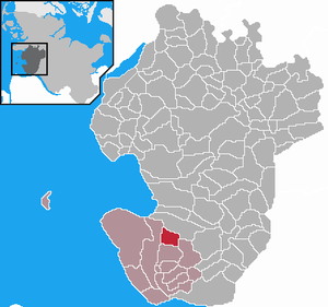
| Location of the community of Trennewurth in the district of Dithmarschen | ||
Trennewurth is a municipality in the Dithmarschen district in Schleswig-Holstein.
geology
Trennewurth is in the Dithmarscher Südermarsch . To the southeast of the Wurt there are two Wehle that were created when dykes broke in the Middle Ages.
Community structure
The community is divided into Trennewurth, Trennewurtheraltendeich, Trennewurtherneuendeich and Trennewurtherkrooge. It is about halfway between Marne and Meldorf . The federal road 5 runs through the municipality.
history
The name derives from the old Wurt , on which the village center of the marshland is located. According to investigations using the radiocarbon method , the oldest part of the Wurt dates from around 200 BC. It was probably given up again at the time of the Great Migration. New traces of settlement can only be found from the Middle Ages. Since the coastal area was higher than in the early days, the Wurt, originally made primarily of dung, had to be raised with clay .
On April 1, 1934, the parish of Marne was dissolved. All of their village communities, village communities and farmers became independent communities / rural communities, including Trennewurth-Trennewurtherdeich.
On March 1, 1971 the name of the community Trennewurth-Trennewurtherdeich , with 29 letters at that time one of the longest community names in Germany, was officially changed to Trennewurth .
politics
Since the municipal elections in 2013, the KWV voter community has all nine seats in the municipal council.
Daughters and sons of the place
- Peter Jacob Johannssen (1858–1941), German agricultural scientist, teacher at various agricultural schools, General Secretary of the Royal Agricultural Society in Hanover, Director of the Hanover Chamber of Agriculture and State Economics Council
Web links
Individual evidence
- ↑ North Statistics Office - Population of the municipalities in Schleswig-Holstein 4th quarter 2019 (XLSX file) (update based on the 2011 census) ( help on this ).
- ↑ Schleswig-Holstein topography. Vol. 10: Timmaspe - Ziethen . 1st edition Flying-Kiwi-Verl. Junge, Flensburg 2008, ISBN 978-3-926055-92-7 , p. 53 ( dnb.de [accessed on August 6, 2020]).
- ↑ State Statistical Office Schleswig-Holstein (Ed.): The population of the communities in Schleswig-Holstein 1867-1970 . State Statistical Office Schleswig-Holstein, Kiel 1972, p. 250 .
- ^ Federal Statistical Office (ed.): Historical municipality directory for the Federal Republic of Germany. Name, border and key number changes in municipalities, counties and administrative districts from May 27, 1970 to December 31, 1982 . W. Kohlhammer, Stuttgart / Mainz 1983, ISBN 3-17-003263-1 , p. 181 .
- ^ Community representative of the community of Trennewurth
- ^ Helmut Zimmermann : Johannssenstrasse . In: ders .: The street names of the state capital Hanover. Verlag Hahnsche Buchhandlung, Hannover 1992, ISBN 3-7752-6120-6 , p. 133


