
Schlichting
| coat of arms | Germany map | |
|---|---|---|

|
Coordinates: 54 ° 19 ' N , 9 ° 5' E |
|
| Basic data | ||
| State : | Schleswig-Holstein | |
| Circle : | Dithmarschen | |
| Office : | Parish land parishes of Eider | |
| Height : | 7 m above sea level NHN | |
| Area : | 12.5 km 2 | |
| Residents: | 236 (Dec. 31, 2019) | |
| Population density : | 19 inhabitants per km 2 | |
| Postal code : | 25779 | |
| Primaries : | 04836, 04882 | |
| License plate : | HEI, MED | |
| Community key : | 01 0 51 102 | |
| Office administration address: | Kirchspielsschreiber-Schmidt-Straße 1 25779 Hennstedt |
|
| Website : | ||
| Mayor : | Dieter Lipski (AWS) | |
| Location of the municipality Schlichting in the district of Dithmarschen | ||
 |
||

Schlichting is a municipality in the Dithmarschen district in Schleswig-Holstein .
geography
The agricultural row village is on the border of a moorland between Hennstedt and Lunden and the Eidermarsch in the Eider-Treene lowland . Due to the former regular flooding of the Eider, the village center was built on Wurten. The underground still ensures that houses occasionally sag.
Schlichting can be reached via Landesstraße 302 , the next national train station is in Heide .
The community is divided into the parts Schlichting, Schlichtingermoor, Schlichtinger Neuerkoog, Hauberg and Buttermilchskrug.
history
In 1544 an independent church was mentioned for the first time.
Today's St. Rochus Church was built after 1670, most of the furnishings date from the years 1700 to 1730. It is located in the middle of the village on a Wurt . The church is the only object on the list of cultural monuments in Schlichting .
On April 1, 1934, the parish state community Hennstedt was dissolved. All of their village communities, village communities and farmers became independent communities / rural communities, including Schlichting.
politics
Of the nine seats in the municipal council, the constituency AWS has had six seats since the 2013 local elections and the constituency AWGS three.
religion
The Schlichting parish is the smallest in the district.
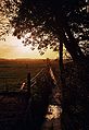
View of the valley from the town center
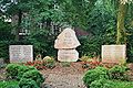
Cenotaph for the fallen of the two world wars


Web links
Individual evidence
- ↑ North Statistics Office - Population of the municipalities in Schleswig-Holstein 4th quarter 2019 (XLSX file) (update based on the 2011 census) ( help on this ).
- ↑ Schleswig-Holstein topography. Vol. 8: Pölitz - Schönbek . 1st edition Flying-Kiwi-Verl. Junge, Flensburg 2007, ISBN 978-3-926055-89-7 , pp. 328 ( dnb.de [accessed July 24, 2020]).
- ↑ State Statistical Office Schleswig-Holstein (Ed.): The population of the communities in Schleswig-Holstein 1867-1970 . State Statistical Office Schleswig-Holstein, Kiel 1972, p. 251 .
- ↑ Final result of the local elections 2013 ( page no longer available , search in web archives ) Info: The link was automatically marked as defective. Please check the link according to the instructions and then remove this notice.

Cities: Brunsbüttel | Büsum | Heather | Marne | Meldorf | Wesselburen
Other communities: Albersdorf | Arkebek | Averlak | Bargenstedt | Barkenholm | Barlt | Berggewöhrden | Brickling | Buchholz | Bunsoh | Castle (Dithmarschen) | Busenwurth | Büsumer Deichhausen | Dellstedt | Delve | Diekhusen-Fahrstedt | Things | Dörpling | Eddelak | Eggstedt | Elpersbüttel | Epenwöhrden | Fedderingen | Frestedt | Friedrichsgabekoog | Friedrichskoog | Gaushorn | Glüsing | Great Wheel | Groven | Gudendorf | Hedwigenkoog | Hellschen-Herringand-Unterschaar | Helse | Inhibit | Hemmingstedt | Hennstedt | Hillgroven | Hochdonn | Hollingstedt | Hövede | Immenstedt | Kaiser-Wilhelm-Koog | Karolinenkoog | Kleve | Clutter | Kronprinzenkoog | Krumstedt | Kuden | Lehe | Lieth | Linden | Lohe-Rickelshof | Lunden | Marnerdeich | Neuenkirchen | Neufeld | Neufelderkoog | Nindorf | North dike | Norderheistedt | Nordermeldorf | Norderwöhrden | Nordhastedt | Odderade | Oesterdeichstrich | Oesterwurth | Offenbüttel | Easter wheel | Ostrohe | Pahlen | Quickborn | Ramhusen | Rehm-Flehde-Bargen | Reinsbüttel | Saint Anne | Sankt Michaelisdonn | Sarzbüttel | Schafstedt | Schalkholz | Schlichting | Schmedeswurth | Schrum | Schülp | Place-Wittenwurth | Strübbel | Süderdeich | Süderdorf | Süderhastedt | Süderheistedt | Tellingstedt | Tensbüttel roast | Tielenhemme | Trennewurth | Volsemenhusen | Wallen | Warwerort | Weddingstedt | Welmbüttel | Wennbüttel | Wesselburener Deichhausen | Wesselburenerkoog | Wesseln | Westerborstel | Westerdeichstrich | Wiemerstedt | Wind mountains | Woehrden | Wolmersdorf | Wrohm