
Easter wheel
| coat of arms | Germany map | |
|---|---|---|

|
Coordinates: 54 ° 11 ' N , 9 ° 21' E |
|
| Basic data | ||
| State : | Schleswig-Holstein | |
| Circle : | Dithmarschen | |
| Office : | Mitteldithmarschen | |
| Height : | 23 m above sea level NHN | |
| Area : | 17.09 km 2 | |
| Residents: | 413 (Dec. 31, 2019) | |
| Population density : | 24 inhabitants per km 2 | |
| Postal code : | 25767 | |
| Primaries : | 04802, 04835 | |
| License plate : | HEI, MED | |
| Community key : | 01 0 51 086 | |
| Office administration address: | Hindenburgstrasse 18 25704 Meldorf |
|
| Website : | ||
| Mayor : | Peter Hinrichsen (AWO) | |
| Location of the municipality of Osterrade in the Dithmarschen district | ||
 |
||

Osterrade is a municipality in the Dithmarschen district in Schleswig-Holstein .
geography
location
The municipality of Osterrade is located on the northeastern Dithmarscher Geest and extends into the moors of the Gieselau and Eider .
Community structure
The community consists of the districts Christianshütte, Heinkenstruck, Jützbüttel, Osterrade, Redder, Schormoor and Süderrade.
Neighboring communities
Neighboring communities are the communities Süderdorf and Wrohm (both in the district of Dithmarschen), Hamdorf and Oldenbüttel (both in the district of Rendsburg-Eckernförde ) and Offenbüttel , Bunsoh and Immenstedt (all in turn in the district of Dithmarschen), starting clockwise in the northwest .
history
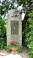
The community has a memorial for the Russian prisoners of war who died in the Süderrade labor camp during the First World War (Lage) .
On April 1, 1934, the parish of Albersdorf was dissolved. All of their village communities, village communities and farmers became independent communities / rural communities, including Osterrade.
Incorporations
On January 1, 1974, the previously independent communities of Jützbüttel and Süderrade were incorporated.
coat of arms
Blazon : "In silver over a red three-mountain, which is covered with a silver key with a beard on the left and below, a red peat spade crossed diagonally with the leaf above and a red clearing hoe."
The Dreiberg stands for the three former villages of Osterrade, Jützbüttel and Süderrade. Osterrade is the oldest documented place in the parish of Albersdorf through the Peterskapelle mentioned in 1272. This is symbolized by the Peter key. The clearing hoe points to the two clearing locations Oster- and Süderrade, the peat spade to the two districts of Christianshütte and Schormoor located in the moor . The coloring is derived from the Dithmarsch state colors.
photos
memorial

Web links
Individual evidence
- ↑ North Statistics Office - Population of the municipalities in Schleswig-Holstein 4th quarter 2019 (XLSX file) (update based on the 2011 census) ( help on this ).
- ↑ a b c d Schleswig-Holstein topography. Vol. 7: Munkbrarup - Pohnsdorf . 1st edition Flying-Kiwi-Verl. Junge, Flensburg 2006, ISBN 978-3-926055-88-0 , p. 293 ( dnb.de [accessed on July 22, 2020]).
- ↑ Grave site for 55 Russian prisoners of war of the First World War.
- ↑ State Statistical Office Schleswig-Holstein (Ed.): The population of the communities in Schleswig-Holstein 1867-1970 . State Statistical Office Schleswig-Holstein, Kiel 1972, p. 250 .
- ^ Federal Statistical Office (ed.): Historical municipality directory for the Federal Republic of Germany. Name, border and key number changes in municipalities, counties and administrative districts from May 27, 1970 to December 31, 1982 . W. Kohlhammer, Stuttgart / Mainz 1983, ISBN 3-17-003263-1 , p. 181 .
- ↑ Schleswig-Holstein's municipal coat of arms

Cities: Brunsbüttel | Büsum | Heather | Marne | Meldorf | Wesselburen
Other communities: Albersdorf | Arkebek | Averlak | Bargenstedt | Barkenholm | Barlt | Berggewöhrden | Brickling | Buchholz | Bunsoh | Castle (Dithmarschen) | Busenwurth | Büsumer Deichhausen | Dellstedt | Delve | Diekhusen-Fahrstedt | Things | Dörpling | Eddelak | Eggstedt | Elpersbüttel | Epenwöhrden | Fedderingen | Frestedt | Friedrichsgabekoog | Friedrichskoog | Gaushorn | Glüsing | Great Wheel | Groven | Gudendorf | Hedwigenkoog | Hellschen-Herringand-Unterschaar | Helse | Inhibit | Hemmingstedt | Hennstedt | Hillgroven | Hochdonn | Hollingstedt | Hövede | Immenstedt | Kaiser-Wilhelm-Koog | Karolinenkoog | Kleve | Clutter | Kronprinzenkoog | Krumstedt | Kuden | Lehe | Lieth | Linden | Lohe-Rickelshof | Lunden | Marnerdeich | Neuenkirchen | Neufeld | Neufelderkoog | Nindorf | North dike | Norderheistedt | Nordermeldorf | Norderwöhrden | Nordhastedt | Odderade | Oesterdeichstrich | Oesterwurth | Offenbüttel | Easter wheel | Ostrohe | Pahlen | Quickborn | Ramhusen | Rehm-Flehde-Bargen | Reinsbüttel | Saint Anne | Sankt Michaelisdonn | Sarzbüttel | Schafstedt | Schalkholz | Schlichting | Schmedeswurth | Schrum | Schülp | Place-Wittenwurth | Strübbel | Süderdeich | Süderdorf | Süderhastedt | Süderheistedt | Tellingstedt | Tensbüttel roast | Tielenhemme | Trennewurth | Volsemenhusen | Wallen | Warwerort | Weddingstedt | Welmbüttel | Wennbüttel | Wesselburener Deichhausen | Wesselburenerkoog | Wesseln | Westerborstel | Westerdeichstrich | Wiemerstedt | Wind mountains | Woehrden | Wolmersdorf | Wrohm