Busenwurth
| coat of arms | Germany map | |
|---|---|---|

|
Coordinates: 54 ° 2 ′ N , 9 ° 2 ′ E |
|
| Basic data | ||
| State : | Schleswig-Holstein | |
| Circle : | Dithmarschen | |
| Office : | Mitteldithmarschen | |
| Height : | 3 m above sea level NHN | |
| Area : | 10.09 km 2 | |
| Residents: | 310 (Dec. 31, 2019) | |
| Population density : | 31 inhabitants per km 2 | |
| Postal code : | 25719 | |
| Primaries : | 04857, 04859 | |
| License plate : | HEI, MED | |
| Community key : | 01 0 51 017 | |
| LOCODE : | DE EWT | |
| Office administration address: | Hindenburgstrasse 18 25704 Meldorf |
|
| Website : | ||
| Mayoress : | Sabine Möhring | |
| Location of the municipality of Busenwurth in the Dithmarschen district | ||
Busenwurth is a municipality in the Dithmarschen district in Schleswig-Holstein . Busenwurtherdeich and Wolfenbüttel are in the municipality.
geography
location
The march community borders on the North Sea . It is on federal highway 5 .
Neighboring communities
Neighboring communities are the communities of Elpersbüttel , Gudendorf and Barlt (all in the Dithmarschen district), starting clockwise in the north .
history
Busenwurth consists of two, about a kilometer apart Wurtendörfern . Archaeological excavations have documented their age. Süderbusenwurth was built in the middle of the 1st century as a group of several stable houses on a bank wall on a priel . The Wurt was increased after 150 and left around the year 200. The Wurt was repopulated in the 12th century.
Norderbusenwurth is younger and only dates back to the middle of the 11th century at the earliest. Excavations here show a building from this period. Both Wurten were included in the medieval sea dike of the Dithmarscher Südermarsch, which is no longer preserved here.
On April 1, 1934, the parish district of Südermeldorf-Marsch was dissolved. All of their village communities, village communities and farmers became independent communities / rural communities, including Busenwurth.
coat of arms
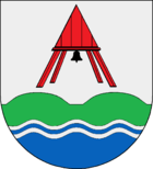
Blazon : “Two flattened green hills above a blue wave shield with two silver wave threads. Above it, in silver, a red bell tower with a black bell. "
literature
- Dirk Meier: The North Sea Coast: History of a Landscape. Boyens-Buchverlag, Heide 2006.
Web links
Individual evidence
- ↑ North Statistics Office - Population of the municipalities in Schleswig-Holstein 4th quarter 2019 (XLSX file) (update based on the 2011 census) ( help on this ).
- ↑ Schleswig-Holstein topography. Vol. 2: Boren - Ellerau . 1st edition Flying-Kiwi-Verl. Junge, Flensburg 2002, ISBN 978-3-926055-68-2 , p. 194 ( dnb.de [accessed June 11, 2020]).
- ↑ State Statistical Office Schleswig-Holstein (Ed.): The population of the communities in Schleswig-Holstein 1867-1970 . State Statistical Office Schleswig-Holstein, Kiel 1972, p. 250 .


