
Schrum
| coat of arms | Germany map | |
|---|---|---|

|
Coordinates: 54 ° 11 ′ N , 9 ° 15 ′ E |
|
| Basic data | ||
| State : | Schleswig-Holstein | |
| Circle : | Dithmarschen | |
| Office : | Mitteldithmarschen | |
| Height : | 72 m above sea level NHN | |
| Area : | 5 km 2 | |
| Residents: | 72 (Dec. 31, 2019) | |
| Population density : | 14 inhabitants per km 2 | |
| Postal code : | 25782 | |
| Area code : | 04835 | |
| License plate : | HEI, MED | |
| Community key : | 01 0 51 104 | |
| Office administration address: | Hindenburgstrasse 18 25704 Meldorf |
|
| Website : | ||
| Mayor : | Heinrich Horning-Thomsen | |
| Location of the municipality of Schrum in the Dithmarschen district | ||
 |
||

Schrum is a municipality in the Dithmarschen district in Schleswig-Holstein .
history
Like many other communities in Dithmarschen, Schrum is also mentioned in the complaints from 1447 (Michelsen document book, p. 45/46). The year 1402 can be named here from the list of the text. It reads there, "... when one wrote fourteen hundred in the other year, the Wednesday next before the honorable feast, it was called the feast of Christ's corpse ...", from which the 24th May 1402 results.
The church in Tellingstedt can be seen as a lower church of the Meldorfer church . Schrum is not mentioned from the time this church was founded. But there are some records about Schrum (Scrume) from the 15th century, when Schrum still belonged to the parish of Tellingstedt. Only after the “ last feud ” in 1559, when Dithmarschen was divided into three parts, Schrum came to Süderdithmarschen and thus to the parish of Albersdorf.
On April 1, 1934, the parish of Albersdorf was dissolved. All of their village communities, village communities and farmers became independent communities / rural communities, including Schrum.
Geography and traffic
The community with its wooded Geest area has with 78.81 m above sea level. NN , behind the “Grimmstal” stud, the highest point in the Dithmarschen district. This point lies in today's meadow, which was called “Karghöde” on the map from 1872–73. In "Die Flurnamen Dithmarschens" (Wegemann, Kiel 1941) is on page 12 in Volume II: "to Süderstöven" 79m high, Mtbl . This field name was taken from the parcel designated in 1872 (Stüf / Stüfbarg) south of the highest point in Schrum, but it is only just over 75 m above sea level. NN . This height is now on the military training area and is called "LSG Height 75". The 7.9630 hectare area was already declared a landscape protection area with the ordinance of March 25, 1938. The community can be reached via the district road 40, which branches off the federal road 203 in Welmbüttel and runs in the direction of Albersdorf / Arkebek .
landscape
Schrum is a small village that is largely characterized by farms and horse breeding and is surrounded by quiet, contemplative paths through forests and meadows. The place has twelve listed hill and stone graves, of which a destroyed long bed and six mounds are on a plot in the south of the community. The remaining five with two stately hills are located on the grounds of the "Riese" military training area.
photos
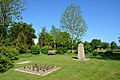
Cenotaph for the dead of the world wars

Web links
Individual evidence
- ↑ North Statistics Office - Population of the municipalities in Schleswig-Holstein 4th quarter 2019 (XLSX file) (update based on the 2011 census) ( help on this ).
- ↑ State Statistical Office Schleswig-Holstein (Ed.): The population of the communities in Schleswig-Holstein 1867-1970 . State Statistical Office Schleswig-Holstein, Kiel 1972, p. 250 .

Cities: Brunsbüttel | Büsum | Heather | Marne | Meldorf | Wesselburen
Other communities: Albersdorf | Arkebek | Averlak | Bargenstedt | Barkenholm | Barlt | Berggewöhrden | Brickling | Buchholz | Bunsoh | Castle (Dithmarschen) | Busenwurth | Büsumer Deichhausen | Dellstedt | Delve | Diekhusen-Fahrstedt | Things | Dörpling | Eddelak | Eggstedt | Elpersbüttel | Epenwöhrden | Fedderingen | Frestedt | Friedrichsgabekoog | Friedrichskoog | Gaushorn | Glüsing | Great Wheel | Groven | Gudendorf | Hedwigenkoog | Hellschen-Herringand-Unterschaar | Helse | Inhibit | Hemmingstedt | Hennstedt | Hillgroven | Hochdonn | Hollingstedt | Hövede | Immenstedt | Kaiser-Wilhelm-Koog | Karolinenkoog | Kleve | Clutter | Kronprinzenkoog | Krumstedt | Kuden | Lehe | Lieth | Linden | Lohe-Rickelshof | Lunden | Marnerdeich | Neuenkirchen | Neufeld | Neufelderkoog | Nindorf | North dike | Norderheistedt | Nordermeldorf | Norderwöhrden | Nordhastedt | Odderade | Oesterdeichstrich | Oesterwurth | Offenbüttel | Easter wheel | Ostrohe | Pahlen | Quickborn | Ramhusen | Rehm-Flehde-Bargen | Reinsbüttel | Saint Anne | Sankt Michaelisdonn | Sarzbüttel | Schafstedt | Schalkholz | Schlichting | Schmedeswurth | Schrum | Schülp | Place-Wittenwurth | Strübbel | Süderdeich | Süderdorf | Süderhastedt | Süderheistedt | Tellingstedt | Tensbüttel roast | Tielenhemme | Trennewurth | Volsemenhusen | Wallen | Warwerort | Weddingstedt | Welmbüttel | Wennbüttel | Wesselburener Deichhausen | Wesselburenerkoog | Wesseln | Westerborstel | Westerdeichstrich | Wiemerstedt | Wind mountains | Woehrden | Wolmersdorf | Wrohm