Prickling
| coat of arms | Germany map | |
|---|---|---|

|
Coordinates: 54 ° 1 ' N , 9 ° 13' E |
|
| Basic data | ||
| State : | Schleswig-Holstein | |
| Circle : | Dithmarschen | |
| Office : | Burg-Sankt Michaelisdonn | |
| Height : | 8 m above sea level NHN | |
| Area : | 6.07 km 2 | |
| Residents: | 212 (Dec. 31, 2019) | |
| Population density : | 35 inhabitants per km 2 | |
| Postal code : | 25712 | |
| Area code : | 04825 | |
| License plate : | HEI, MED | |
| Community key : | 01 0 51 010 | |
| LOCODE : | DE CLN | |
| Office administration address: | Holzmarkt 7 25712 Burg |
|
| Website : | ||
| Mayor : | Hans-Henning Beeck (KWV) | |
| Location of the municipality of Brickeln in the Dithmarschen district | ||
Brickeln is a municipality in the Dithmarschen district in Schleswig-Holstein . Hochdonner Barg is located in the municipality.
geography
Geographical location
The street village of Brickeln is located on the state road 140 between Quickborn and Burg (Dithmarschen) in the Dithmarscher Geest landscape . The Helmscher Bach flows along the northern municipal boundary .
Neighboring communities
Brickeln borders on:
| Great Wheel | ||
| Quickborn |

|
Hochdonn |
| Buchholz | Castle (Dithmarschen) |
history
The place name Brickeln suggests a verbal connection to "birch". Linguists derive the name Brickeln from “Brickloh”, synonymous with “Woody grove, where wood is cut for slices (Low German: Bricken )”.
On April 1, 1934, the parish of Burg was dissolved. All of their village communities, village communities and farmers became independent communities / rural communities, including Brickeln.
politics
Community representation
After the local elections in 2018, the KWV electoral community has all nine seats in the municipal council.
coat of arms
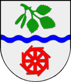
Blazon : "A blue wave bar in silver, accompanied by a green birch branch at the top and an eight-spoke red water wheel at the bottom."
The birch branches in the municipality's coat of arms indicate the possible origin of the name Brickeln. The wave bar symbolizes the Helmschen Bach, which flows through the municipality. The water wheel is a reminder of the Brickeln watermill, which was once a remarkable business enterprise and located on this very stream. In the middle of the last century the operation was closed and the building was later demolished after the mill had existed for at least 200 years.
personality
- Johann Kruse (1889–1983), witch researcher
Individual evidence
- ↑ North Statistics Office - Population of the municipalities in Schleswig-Holstein 4th quarter 2019 (XLSX file) (update based on the 2011 census) ( help on this ).
- ↑ Schleswig-Holstein topography. Vol. 2: Boren - Ellerau . 1st edition Flying-Kiwi-Verl. Junge, Flensburg 2002, ISBN 978-3-926055-68-2 , p. 108 ( dnb.de [accessed June 11, 2020]).
- ↑ State Statistical Office Schleswig-Holstein (Ed.): The population of the communities in Schleswig-Holstein 1867-1970 . State Statistical Office Schleswig-Holstein, Kiel 1972, p. 250 .
- ↑ Schleswig-Holstein's municipal coat of arms


