Marnerdeich
| coat of arms | Germany map | |
|---|---|---|

|
Coordinates: 53 ° 57 ' N , 8 ° 59' E |
|
| Basic data | ||
| State : | Schleswig-Holstein | |
| Circle : | Dithmarschen | |
| Office : | Marne North Sea | |
| Height : | 2 m above sea level NHN | |
| Area : | 1.31 km 2 | |
| Residents: | 396 (Dec. 31, 2019) | |
| Population density : | 302 inhabitants per km 2 | |
| Postal code : | 25709 | |
| Area code : | 04851 | |
| License plate : | HEI, MED | |
| Community key : | 01 0 51 073 | |
| Office administration address: | Old churchyard 4/5 25709 Marne |
|
| Website : | ||
| Mayor : | Carsten Höhnke (KWV) | |
| Location of the municipality of Marnerdeich in the district of Dithmarschen | ||
Marnerdeich is a municipality in the south of the Dithmarschen district in Schleswig-Holstein .
geography
Location type
Marnerdeich has the character of a row village, located on both sides of the state road 142 running in west-east direction and on the east side of the municipal road running in north-south direction.
Neighboring communities
Neighboring communities are the community of Helse , the city of Marne and the communities of Neufeld and Kronprinzenkoog (all in the district of Dithmarschen), starting clockwise in the northeast .
history
The land lying in the marshland was diked from 1578 to 1581 as part of the Großer Kooges Ammerwurth-Marne .
On April 1, 1934, the parish of Marne was dissolved. All of their villages, village communities and farmers became independent communities / rural communities, including Marnerdeich.
politics
Community representation
The KWV voter community has held all of the nine seats in the municipal council since the local elections in 2018.
coat of arms
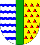
Blazon : “Split by a green pole. In front six blue wavy bars in silver; behind of gold, sprinkled with red triangles. "
The place name points with its double meaning to the history of the community. Marnerdeich was the name given to the dike, which was probably built at the beginning of the 17th century to protect the parish of Marne . Over time, the name was transferred to the new settlement that was formed behind the dike. The village "Marnerdiek" is mentioned for the first time in 1664. The post in the coat of arms symbolizes the dike with its greenery. The red triangles, interpreted as houses, are intended to represent the Marne parish, but also refer to the Marnerdeich settlement. At the same time, both the stylized houses and the stake depict the place name. The golden shield color of the left half of the coat of arms indicates the cornfields behind the dike, the wavy threads in the silver field symbolize the sea, the Blanken Hans .
Web links
Individual evidence
- ↑ North Statistics Office - Population of the municipalities in Schleswig-Holstein 4th quarter 2019 (XLSX file) (update based on the 2011 census) ( help on this ).
- ↑ State Statistical Office Schleswig-Holstein (Ed.): The population of the communities in Schleswig-Holstein 1867-1970 . State Statistical Office Schleswig-Holstein, Kiel 1972, p. 250 .
- ↑ Schleswig-Holstein's municipal coat of arms


