Wesselburenerkoog
| coat of arms | Germany map | |
|---|---|---|

|
Coordinates: 54 ° 14 ' N , 8 ° 53' E |
|
| Basic data | ||
| State : | Schleswig-Holstein | |
| Circle : | Dithmarschen | |
| Office : | Büsum-Wesselburen | |
| Height : | 2 m above sea level NHN | |
| Area : | 21.89 km 2 | |
| Residents: | 178 (Dec. 31, 2019) | |
| Population density : | 8 inhabitants per km 2 | |
| Postal code : | 25764 | |
| Area code : | 04833 | |
| License plate : | HEI, MED | |
| Community key : | 01 0 51 129 | |
| Office administration address: | Kaiser Wilhelm-Platz 25761 Büsum |
|
| Website : | ||
| Mayor : | Eggert Wilkens (WGW) | |
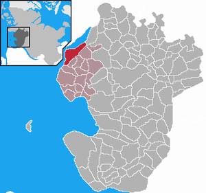
| Location of the municipality of Wesselburenerkoog in the Dithmarschen district | ||
Wesselburenerkoog is a municipality in the Dithmarschen district in Schleswig-Holstein . Seehof is located in the municipality.
geography
The Koog was created by dike in 1862. The community was created in 1934 from a part of the parish land community Wesselburen and had 313 inhabitants at that time. Wesselburenerkoog is located directly at the mouth of the Eider in the North Sea and forms the southern access to the Eider Barrage . One of the diked areas was the Hundeknöll foreland, which later became the official end point of the barrier when the Eider Barrage was built.
history
The landscape served as a foreland - not protected from the North Sea. The farmers from Wesselburen and Norddeich let their sheep and other livestock graze on the area crossed by priels . In 1819, the farmers of Norddeich built a ring dike at the highest point, the place of the highest spring , in which there was a cattle trough . The dike, the remains of which can still be seen today, had a diameter of 200 meters. With a height of 5.80 m, it was slightly lower than regular sea dikes at the time. The ring dike trough ensured both the fresh water supply for the cattle and also protected them from storm surges into autumn. About 1000 sheep and cattle could be housed on the two hectare property.
On April 1, 1934, the parish land community Wesselburen was dissolved. All of their village communities, village communities and farmers became independent communities / rural communities, including Wesselburenerkoog.
With the construction of the Eider Barrage in the 1970s, the area of the municipality, which was created as Koog through land reclamation, grew again. The municipality has its own bathing area on the North Sea , a campsite and, since 2003, a holiday home area in the Scandinavian style. Part of the protected Dithmarscher Eiderwatt also belong to the municipality.
politics
Since the local elections in 2013, the WGW voter community has all seven seats in the local council.
Sons and daughters of the church
- Theodor Wisch (born December 13, 1907 in Wesselburenerkoog, † January 11, 1995 in Norderstedt), SS brigade leader and major general of the Waffen SS
Web links
Individual evidence
- ↑ North Statistics Office - Population of the municipalities in Schleswig-Holstein 4th quarter 2019 (XLSX file) (update based on the 2011 census) ( help on this ).
- ↑ Schleswig-Holstein topography. Vol. 10: Timmaspe - Ziethen . 1st edition Flying-Kiwi-Verl. Junge, Flensburg 2008, ISBN 978-3-926055-92-7 , p. 232 ( dnb.de [accessed on August 9, 2020]).
- ↑ State Statistical Office Schleswig-Holstein (Ed.): The population of the communities in Schleswig-Holstein 1867-1970 . State Statistical Office Schleswig-Holstein, Kiel 1972, p. 251 .
- ↑ Community representative in the Büsum-Wesselburen office


