
Reinsbüttel
| coat of arms | Germany map | |
|---|---|---|

|
Coordinates: 54 ° 11 ' N , 8 ° 54' E |
|
| Basic data | ||
| State : | Schleswig-Holstein | |
| Circle : | Dithmarschen | |
| Office : | Büsum-Wesselburen | |
| Height : | 2 m above sea level NHN | |
| Area : | 6.83 km 2 | |
| Residents: | 384 (Dec. 31, 2019) | |
| Population density : | 56 inhabitants per km 2 | |
| Postal code : | 25764 | |
| Area code : | 04833 | |
| License plate : | HEI, MED | |
| Community key : | 01 0 51 093 | |
| Office administration address: | Kaiser Wilhelm-Platz 25761 Büsum |
|
| Website : | ||
| Mayor : | Dirk Rathje (WGR) | |
| Location of the municipality of Reinsbüttel in the Dithmarschen district | ||
 |
||

Reinsbüttel is a municipality in the Dithmarschen district in Schleswig-Holstein .
Geography and traffic
The place is on the railway line Büsum – Heide (Holstein) –Neumünster .
Geographical location
Reinsbüttel lies between Süderdeich and Oesterdeichstrich , the weir dam built in 1585 used to lead via Reinsbüttel to what was then the island of Büsum . The place is located on a Langwurt originally built in the 12th century . In contrast to the village sausages, these mostly served the Saxon trade - in Reinsbüttel handled via a small North Sea port. Due to further dikes, Reinsbüttel lost direct access to the North Sea in 1609 .
Community structure
Reinsbüttel, Reinsbüttlerweide, Wahrdamm and Weidehof
history
In terms of settlement history, Reinsbüttel is one of the Büttel localities.
Reinsbüttel is located on a Dorfwurt , which shows that it was originally close to the sea and was threatened by storm surges. It was not until Büsum was dyed in 1585 that it lost direct access to the sea. The agricultural area was a pioneer of small-scale industrialization in Dithmarschen. Shortly after the Dithmarschers discovered how profitable cabbage cultivation was in the region (see also Dithmarscher Kohltage ), the region's first sauerkraut factory was built here in 1898 .
On April 1, 1934, the parish land community Wesselburen was dissolved. All of their villages, village communities and farmers became independent communities / rural communities, including Reinsbüttel.
politics
Community representation
Since the local elections in 2013, the WGR electoral community has all nine seats in the municipal council.
coat of arms
Blazon : “Divided by a divided, above silver, below blue wave bar of green and gold. Above a silver thatched roof from the eaves, below a black wooden farmer's wagon. "
The coat of arms of Reinsbüttel is divided into two halves by the symbolic Wartstrom . The thatched roof reminds of the first settlement. The green background represents the colors of the marsh meadows . The farmer's wagon is evidence of the hard work on the land and local handicrafts. The golden background symbolizes ripe grain fields.
Sports
Reinsbüttel is one of the strongholds of Boßeln in the Dithmarschen district.
photos

Former sauerkraut factory
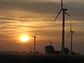
Windmills shape the landscape

It is located in the rural marshland
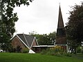
Reinsbüttel chapel


Web links
Individual evidence
- ↑ North Statistics Office - Population of the municipalities in Schleswig-Holstein 4th quarter 2019 (XLSX file) (update based on the 2011 census) ( help on this ).
- ↑ Schleswig-Holstein topography. Vol. 8: Pölitz - Schönbek . 1st edition Flying-Kiwi-Verl. Junge, Flensburg 2007, ISBN 978-3-926055-89-7 , pp. 139 ( dnb.de [accessed on July 23, 2020]).
- ↑ State Statistical Office Schleswig-Holstein (Ed.): The population of the communities in Schleswig-Holstein 1867-1970 . State Statistical Office Schleswig-Holstein, Kiel 1972, p. 251 .
- ↑ Community representative in the Büsum-Wesselburen office
- ↑ Schleswig-Holstein's municipal coat of arms

Cities: Brunsbüttel | Büsum | Heather | Marne | Meldorf | Wesselburen
Other communities: Albersdorf | Arkebek | Averlak | Bargenstedt | Barkenholm | Barlt | Berggewöhrden | Brickling | Buchholz | Bunsoh | Castle (Dithmarschen) | Busenwurth | Büsumer Deichhausen | Dellstedt | Delve | Diekhusen-Fahrstedt | Things | Dörpling | Eddelak | Eggstedt | Elpersbüttel | Epenwöhrden | Fedderingen | Frestedt | Friedrichsgabekoog | Friedrichskoog | Gaushorn | Glüsing | Great Wheel | Groven | Gudendorf | Hedwigenkoog | Hellschen-Herringand-Unterschaar | Helse | Inhibit | Hemmingstedt | Hennstedt | Hillgroven | Hochdonn | Hollingstedt | Hövede | Immenstedt | Kaiser-Wilhelm-Koog | Karolinenkoog | Kleve | Clutter | Kronprinzenkoog | Krumstedt | Kuden | Lehe | Lieth | Linden | Lohe-Rickelshof | Lunden | Marnerdeich | Neuenkirchen | Neufeld | Neufelderkoog | Nindorf | North dike | Norderheistedt | Nordermeldorf | Norderwöhrden | Nordhastedt | Odderade | Oesterdeichstrich | Oesterwurth | Offenbüttel | Easter wheel | Ostrohe | Pahlen | Quickborn | Ramhusen | Rehm-Flehde-Bargen | Reinsbüttel | Saint Anne | Sankt Michaelisdonn | Sarzbüttel | Schafstedt | Schalkholz | Schlichting | Schmedeswurth | Schrum | Schülp | Place-Wittenwurth | Strübbel | Süderdeich | Süderdorf | Süderhastedt | Süderheistedt | Tellingstedt | Tensbüttel roast | Tielenhemme | Trennewurth | Volsemenhusen | Wallen | Warwerort | Weddingstedt | Welmbüttel | Wennbüttel | Wesselburener Deichhausen | Wesselburenerkoog | Wesseln | Westerborstel | Westerdeichstrich | Wiemerstedt | Wind mountains | Woehrden | Wolmersdorf | Wrohm