Karolinenkoog
| coat of arms | Germany map | |
|---|---|---|

|
Coordinates: 54 ° 18 ' N , 8 ° 58' E |
|
| Basic data | ||
| State : | Schleswig-Holstein | |
| Circle : | Dithmarschen | |
| Office : | Parish land parishes of Eider | |
| Height : | 2 m above sea level NHN | |
| Area : | 17.55 km 2 | |
| Residents: | 143 (Dec. 31, 2019) | |
| Population density : | 8 inhabitants per km 2 | |
| Postal code : | 25774 | |
| Area code : | 04882 | |
| License plate : | HEI, MED | |
| Community key : | 01 0 51 058 | |
| LOCODE : | DE OLI | |
| Office administration address: | Kirchspielsschreiber-Schmidt-Straße 1 25779 Hennstedt |
|
| Website : | ||
| Mayor : | Jens Peter Wiborg (WGK) | |
| Location of the Karolinenkoog community in the Dithmarschen district | ||
Karolinenkoog is a municipality in the north of the Dithmarschen district in Schleswig-Holstein . Schäferhaus, Pfahlershof, Kiekshof, Karolinenhof and Möllers Höfe are in the municipality.
geography
location
The Koog is located on the southeast bank of the Eider opposite the town of Tönning ( North Friesland district ). The area of the Eider beyond the dikes is part of the Dithmarscher Eiderwatt nature reserve .
Neighboring communities
Neighboring communities are the town of Tönning and the community of Oldenswort (both in the district of North Friesland ) and the communities of Groven , Hemme , Strübbel , Schülp and Wesselburenerkoog (all in the district of Dithmarschen), starting clockwise in the northwest .
politics
Community representation
Since the local elections in 2013, the voting community Karolinenkoog WGK has all seven seats in the municipal council.
coat of arms
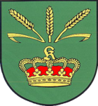
Blazon : "In green under three golden ears of wheat next to each other, the two outer ones inclined outwards, a purple lined golden royal crown, which shows the Fraktur capital letter K instead of a ball and cross."
Economy and Infrastructure
The community is predominantly structured agriculturally. Most of the Dithmarscher cabbage and potatoes are grown there. Smaller service companies are based on site. In Karolinenkoog there is a hotel with various leisure facilities.
traffic
The Koog is cut in the west by the federal highway 5 , on which the district towns Husum ( North Frisia ) and Heide , as well as the federal highway 23 (Heide - Hamburg ) can be reached.
From August 22nd, 1877 to 1940, Karolinenkoog owned a railway connection to Heide from a jetty on the Eider , which mainly served the residents of Tönning to quickly reach this town. Today Karolinenkoog can be reached via the Tönning station ( Husum – Bad St. Peter-Ording line ) on the opposite side of the Eider.
Web links
Individual evidence
- ↑ North Statistics Office - Population of the municipalities in Schleswig-Holstein 4th quarter 2019 (XLSX file) (update based on the 2011 census) ( help on this ).
- ↑ Schleswig-Holstein topography. Vol. 5: Holt - Krokau . 1st edition Flying-Kiwi-Verl. Junge, Flensburg 2005, ISBN 978-3-926055-79-8 , pp. 173 ( dnb.de [accessed on July 20, 2020]).
- ↑ Final result of the local elections 2013 ( page no longer available , search in web archives ) Info: The link was automatically marked as defective. Please check the link according to the instructions and then remove this notice.
- ↑ Schleswig-Holstein's municipal coat of arms


