Süderheistedt
| coat of arms | Germany map | |
|---|---|---|

|
Coordinates: 54 ° 14 ' N , 9 ° 9' E |
|
| Basic data | ||
| State : | Schleswig-Holstein | |
| Circle : | Dithmarschen | |
| Office : | Parish land parishes of Eider | |
| Height : | 5 m above sea level NHN | |
| Area : | 8.44 km 2 | |
| Residents: | 537 (Dec. 31, 2019) | |
| Population density : | 64 inhabitants per km 2 | |
| Postal code : | 25779 | |
| Primaries : | 0481, 04836 | |
| License plate : | HEI, MED | |
| Community key : | 01 0 51 141 | |
| Office administration address: | Kirchspielsschreiber-Schmidt-Straße 1 25779 Hennstedt |
|
| Website : | ||
| Mayoress : | Birgit Meier (WGS) | |
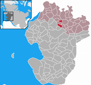
| Location of the municipality of Süderheistedt in the district of Dithmarschen | ||
Süderheistedt is a municipality in the Dithmarschen district in Schleswig-Holstein .
geography
The community is located in the Eider-Treene-Niederung near the district town of Heide on Landesstraße 150.
The community is divided into the districts of Aukrug, Hägen and Süderheistedt.
history
On April 1, 1934, the parish state community Hennstedt was dissolved. All of their villages, village communities and farmers became independent communities / rural communities, including Süderheistedt.
On January 1, 2009 the municipality of Süderheistedt merged with the municipality of Hägen .
politics
Community representation
Since the local elections in 2013, the WGS community of voters has all nine seats in the municipal council.
coat of arms
Blazon : "Above a silver shield base with a yoke-shaped dividing line, inside two turned away green oak leaves, crossed on the stems, enclosing a green acorn, a rooted linden tree in confused colors with crossed twigs, in the recessed center of which a naturally tinged magpie perches."
The wavy dividing line above the base of the shield indicates the Broklandsau , which largely delimits the municipality. This division of the coat of arms is at the same time an allusion to the geographic location of the municipality: On the one hand, the municipal area in the lowland has low-lying bog areas , on the other hand, high-lying geest areas . The linden tree in the center of the coat of arms , in the middle of which stands a magpie , reproduces the so-called "Dithmarsch miracle tree ", which once stood in Süderheistedt, which is confirmed by maps from the early modern period. According to legendary tradition, the mighty old tree, whose branches strangely crossed, were associated with some peculiarities. It was considered a “tree of freedom” because it was said to be green as long as Dithmarschen's freedom exists. It can therefore also be seen as a symbol of Dithmarsch's pride in freedom. When the country lost its freedom due to the last feud in 1559, after the troops of the princes had overcome the fortifications on the Aubrücke near Süderheistedt in the immediate vicinity of the tree, the tree withered in the following years, according to this prophecy. According to an old prophecy, Dithmarschen will regain freedom when a magpie breeds on the tree and raises five white cubs and the tree then turns green again. However, this prophecy never came true, and the tree no longer exists. By depicting the “miracle tree” with the reviving magpie in its coat of arms, the municipality wants to change this symbolically and will also take care of the planting of a young tree in the old place. On the one hand, the green background color alludes to the rural character of the community and, on the other hand, embodies the existing agriculture with its predominantly pastureland uses. In addition, the green tinging should create a link to the community forest . The two oak leaves and their fruit, which cross in the base of the coat of arms, symbolize the Süderheistedter landmark, the Vogelstangenberg. This is a square in the center of the village that is lined with very old oaks. This place embodies the lived and cultivated traditions of the place not only for the bird guild, but also for the other active associations. This is where the village festivals often have their climax. The crossed position of the leaves illustrates the harmony of the associations with one another and the fruit (acorn) its vitality.
Economy and Infrastructure
From 1905 to 1937 the place had a railway connection with the Norderdithmarschen district railway .
Culture and sights
In the center of the village, the Vogelstangenberg, is the last surviving bird's pole in Dithmarschen . The Papagoy Guild , which still exists today and organizes bird shooting , has existed since at least 1621. However, for safety reasons, shooting is nowadays carried out outside the village center.
Web links
Individual evidence
- ↑ North Statistics Office - Population of the municipalities in Schleswig-Holstein 4th quarter 2019 (XLSX file) (update based on the 2011 census) ( help on this ).
- ↑ Schleswig-Holstein topography. Vol. 9: Schönberg - Tielenhemme . 1st edition Flying-Kiwi-Verl. Junge, Flensburg 2007, ISBN 978-3-926055-91-0 , p. 291 ( dnb.de [accessed on August 6, 2020]).
- ↑ State Statistical Office Schleswig-Holstein (Ed.): The population of the communities in Schleswig-Holstein 1867-1970 . State Statistical Office Schleswig-Holstein, Kiel 1972, p. 251 .
- ↑ StBA: Area changes on 01/01/2009
- ↑ Final result of the local elections 2013 ( page no longer available , search in web archives ) Info: The link was automatically marked as defective. Please check the link according to the instructions and then remove this notice.
- ↑ Schleswig-Holstein's municipal coat of arms


