Pahlen
| coat of arms | Germany map | |
|---|---|---|

|
Coordinates: 54 ° 16 ' N , 9 ° 17' E |
|
| Basic data | ||
| State : | Schleswig-Holstein | |
| Circle : | Dithmarschen | |
| Office : | Parish land parishes of Eider | |
| Height : | 12 m above sea level NHN | |
| Area : | 10.8 km 2 | |
| Residents: | 1138 (Dec. 31, 2019) | |
| Population density : | 105 inhabitants per km 2 | |
| Postal code : | 25794 | |
| Area code : | 04803 | |
| License plate : | HEI, MED | |
| Community key : | 01 0 51 088 | |
| LOCODE : | DE 68K | |
| Office administration address: | Kirchspielsschreiber-Schmidt-Straße 1 25779 Hennstedt |
|
| Website : | ||
| Mayor : | Thorsten Reepenn (WGP) | |
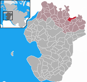
| Location of the municipality of Pahlen in the Dithmarschen district | ||
Pahlen is a municipality in the Dithmarschen district in Schleswig-Holstein . Pahlhude is located in the municipality.
geography
Pahlen can be reached either via the federal highway 23 via Heide or the federal highway 7 and Rendsburg . The place is about halfway between the two cities and can only be reached via country and district roads after leaving the motorway.
history
In the early Middle Ages, Pahlen was to become a bishopric. Adam von Bremen reports in his Gesta Hammaburgensis ecclesiae pontificum around 1065 that the first of twelve bishops sent by Hamburg's Archbishop Adalbert von Bremen should be sent to Palmis on the Eider Estuary, as Pahlen was formerly called. This should be responsible for the west coast there.
The Tielenburg , a medieval fortification, is located in what is now the municipality.
On April 1, 1934, the parish Tellingstedt was dissolved. All of their village communities, village communities and farmers became independent communities / rural communities, including Pahlen.
politics
Of the eleven seats in the municipal council, the WGP electoral community has seven seats and the CDU four seats.
coat of arms
Blazon : “Divided by green and blue, lowered by a narrow silver wavy bar. Above three floating golden rounded poles, the middle one shortened, above this a naturally tinged lapwing, below a silver boat. "
Economy and Infrastructure
From 1905 to 1937 the place Pahlhude had a railway connection with the Norderdithmarschen district railway .
The community is located directly on the Eider and has a boat harbor, water skiing is possible. The area is suitable for canoeing (there has been a canoeing site since 2012), cycling or trail riding. The Pahlen bascule bridge crosses the Eider, which flows along the village.
Well-known is the Pahlazzo , one of the largest discos in Schleswig-Holstein, in the adjoining Eiderlandhalle - which holds around 2000 people - concerts by well-known bands often take place. There is a youth hostel in the village .
Attractions
The list of cultural monuments in Pahlen includes the cultural monuments entered in the list of monuments of Schleswig-Holstein.
Individual evidence
- ↑ North Statistics Office - Population of the municipalities in Schleswig-Holstein 4th quarter 2019 (XLSX file) (update based on the 2011 census) ( help on this ).
- ↑ Schleswig-Holstein topography. Vol. 7: Munkbrarup - Pohnsdorf . 1st edition Flying-Kiwi-Verl. Junge, Flensburg 2006, ISBN 978-3-926055-88-0 , p. 321 ( dnb.de [accessed on July 22, 2020]).
- ^ Tielenauburg near Pahlen
- ↑ The first Tielenburg? The medieval fortifications on the Tielenau near Pahlen (Dithmarschen)
- ↑ State Statistical Office Schleswig-Holstein (Ed.): The population of the communities in Schleswig-Holstein 1867-1970 . State Statistical Office Schleswig-Holstein, Kiel 1972, p. 251 .
- ↑ Schleswig-Holstein's municipal coat of arms


