Strübbel
| coat of arms | Germany map | |
|---|---|---|

|
Coordinates: 54 ° 16 ' N , 8 ° 58' E |
|
| Basic data | ||
| State : | Schleswig-Holstein | |
| Circle : | Dithmarschen | |
| Office : | Büsum-Wesselburen | |
| Height : | 2 m above sea level NHN | |
| Area : | 4.4 km 2 | |
| Residents: | 85 (Dec. 31, 2019) | |
| Population density : | 19 inhabitants per km 2 | |
| Postal code : | 25792 | |
| Area code : | 04837 | |
| License plate : | HEI, MED | |
| Community key : | 01 0 51 108 | |
| Office administration address: | Kaiser Wilhelm-Platz 25761 Büsum |
|
| Website : | ||
| Mayor : | Reimer Jürgens (WGSt) | |
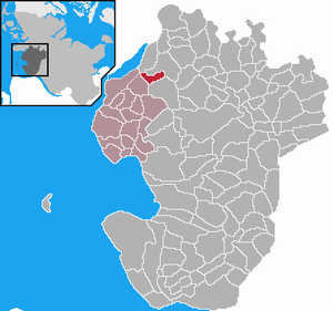
| Location of the Strübbel community in the Dithmarschen district | ||
Strübbel is a municipality in the Dithmarschen district in Schleswig-Holstein . Durchstich, Schülperaltensiel and Schülperneuensiel are located in the municipality.
geography
Strübbel is northeast of Wesselburen in a marshland .
history
On April 1, 1934, the parish land community Wesselburen was dissolved. All of their village communities, village communities and farmers became independent communities / rural communities, including Strübbel.
politics
Since the municipal elections in 2013, the WGSt community of voters has all seven seats in the municipal council.
Web links
Commons : Strübbel - collection of images, videos and audio files
Individual evidence
- ↑ North Statistics Office - Population of the municipalities in Schleswig-Holstein 4th quarter 2019 (XLSX file) (update based on the 2011 census) ( help on this ).
- ↑ Schleswig-Holstein topography. Vol. 9: Schönberg - Tielenhemme . 1st edition Flying-Kiwi-Verl. Junge, Flensburg 2007, ISBN 978-3-926055-91-0 , p. 245 ( dnb.de [accessed on August 6, 2020]).
- ↑ State Statistical Office Schleswig-Holstein (Ed.): The population of the communities in Schleswig-Holstein 1867-1970 . State Statistical Office Schleswig-Holstein, Kiel 1972, p. 251 .
- ↑ Community representative in the Büsum-Wesselburen office


