Hennstedt (Dithmarschen)
| coat of arms | Germany map | |
|---|---|---|

|
Coordinates: 54 ° 17 ' N , 9 ° 10' E |
|
| Basic data | ||
| State : | Schleswig-Holstein | |
| Circle : | Dithmarschen | |
| Office : | Parish land parishes of Eider | |
| Height : | 8 m above sea level NHN | |
| Area : | 21.93 km 2 | |
| Residents: | 1975 (Dec. 31, 2019) | |
| Population density : | 90 inhabitants per km 2 | |
| Postal code : | 25779 | |
| Area code : | 04836 | |
| License plate : | HEI, MED | |
| Community key : | 01 0 51 049 | |
| Office administration address: | Kirchspielsschreiber-Schmidt-Straße 1 25779 Hennstedt |
|
| Website : | ||
| Mayoress : | Anne Riecke ( FDP ) | |
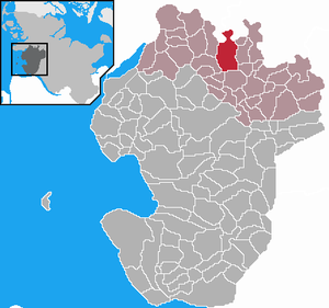
| Location of the community of Hennstedt in the Dithmarschen district | ||
Hennstedt is a municipality in the north of the Dithmarschen district in Schleswig-Holstein .
geography
location
The community is located approx. 4 km south of the Eider in the Eider-Treene lowland .
Community structure
Apeldör, Busch, Feierabend, Horst, Julianka, Kalkerberg, Kleverweg, Kummerfeld, Landweg, Neuhof, Ostermoor, Pferdkrug (sweg), beautification and wilderness are all in the municipality.
Neighboring communities
Neighboring communities are the communities Drage (in the district of North Friesland ), Süderstapel (in the district of Schleswig-Flensburg ) and Bergewöhrden , Hollingstedt , Glüsing , Linden , Süderheistedt , (exclave Hägen ), Fedderingen and Kleve (all in the district of Dithmarschen), starting clockwise in the north .
history
Hennstedt was first mentioned in 1281 as an independent parish . The parish emerged at the same time as numerous other parishes in the 12th and 13th centuries in the first generation after the original parishes of Dithmarschens . It was probably a split from the parish of Tellingstedt .
In the Reichstag election in March 1933 , 91.1% of the votes in the Hennstedt parish were for the NSDAP , 6.3% for the DNVP , 1.5% for the SPD and 0.5% for the KPD, with a turnout of 92.4%.
On April 1, 1934, the parish state community Hennstedt was dissolved. All of their village communities, village communities and farmers became independent communities / rural communities, including their main town, Hennstedt.
politics
Community representation
Of the 13 seats in the municipal council, the CDU has four seats since the 2013 local elections, the electoral community four seats and the FDP five seats.
coat of arms
In 2005, a coat of arms with the associated flag was approved for the municipality of Hennstedts: "Under a green curved shield head, inside a silver wave bar, in gold an eight-spoke red wheel between two slightly lowered green willow branches crossed at the bottom."
Culture and sights
The St. Secundus Church dates from the 13th century. It was built mainly from field stone , using bricks sparingly . The choir is designed in a Gothic style. The nave was later extended to the west. The wooden tower and west wall were renewed in 1847. The pulpit , made in 1651, was made by H. Claussen from Neuenkirchen , the baptism is from 1687, the altar was carved by AH Burmeister from Wesselburen in 1743 and the organ is the work of Tobias Brunner .
See also : List of cultural monuments in Hennstedt
Economy and Infrastructure
From 1905 to 1937 the place had a railway connection with the Norderdithmarschen district railway .
Personalities
Sons and daughters of the church
- Nicolaus Reimers Ursus (1551–1600), court scholar, astronomer and mathematician
- William Martensen (1858–1950), pastor and local history researcher
- Hans Friedrich Micheelsen (1902–1973), composer
- Hans-Herman Rief (1909–2009), art historian and archivist
- Wilhelm Wieben (1935–2019), spokesman for the Tagesschau
- Heinz Teufel (* 1949), photographer
Connected with Hennstedt
- Ludwig Friedrich Hudemann (1703–1770), lawyer and poet, died in Hennstedt
- Hermann Vellguth (1906 – unknown), race hygienist, after 1945 general practitioner in Hennstedt
Web links
Individual evidence
- ↑ North Statistics Office - Population of the municipalities in Schleswig-Holstein 4th quarter 2019 (XLSX file) (update based on the 2011 census) ( help on this ).
- ↑ Schleswig-Holstein topography. Vol. 4: Groß Sarau - Holstenniendorf . 1st edition Flying-Kiwi-Verl. Junge, Flensburg 2004, ISBN 978-3-926055-75-0 , p. 257 ( dnb.de [accessed on May 3, 2020]).
- ↑ AKENS Information 39, Omland: "All of us 'yes' to the leader". Retrieved November 26, 2019 .
- ↑ State Statistical Office Schleswig-Holstein (Ed.): The population of the communities in Schleswig-Holstein 1867-1970 . State Statistical Office Schleswig-Holstein, Kiel 1972, p. 251 .
- ↑ Final result of the local elections 2013 ( page no longer available , search in web archives ) Info: The link was automatically marked as defective. Please check the link according to the instructions and then remove this notice.
- ↑ Schleswig-Holstein's municipal coat of arms


