Mountains of wind
| coat of arms | Germany map | |
|---|---|---|

|
Coordinates: 54 ° 3 ' N , 9 ° 7' E |
|
| Basic data | ||
| State : | Schleswig-Holstein | |
| Circle : | Dithmarschen | |
| Office : | Mitteldithmarschen | |
| Height : | 12 m above sea level NHN | |
| Area : | 17.31 km 2 | |
| Residents: | 792 (Dec. 31, 2019) | |
| Population density : | 46 inhabitants per km 2 | |
| Postal code : | 25729 | |
| Area code : | 04859 | |
| License plate : | HEI, MED | |
| Community key : | 01 0 51 134 | |
| Office administration address: | Hindenburgstrasse 18 25704 Meldorf |
|
| Website : | ||
| Mayor : | Klaus-Peter Groth (Municipal Voters' Association (KWV)) | |
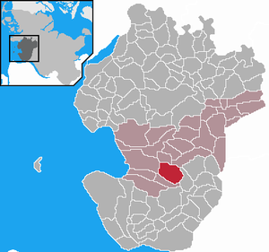
| Location of the municipality of Windbergen in the Dithmarschen district | ||
Windbergen is a municipality in the Dithmarschen district in Schleswig-Holstein .
geography
The community lies on the same ridge of the Heide-Itzehoer Geest on which the city of Meldorf is located.
- Community structure
The districts are Windberger Bahnhof, Spersdiek and Schmalbeck.
history
The community originally belonged to the parish of Meldorf. When a brass figure of Jesus crucified was found in a field in 1495 , the locals built a chapel here. Until the Reformation moved into Dithmarschen in 1533, pilgrimages to the Holy Cross were very popular. In 1547 the church became a parish church.
On April 1, 1934, the parish of Südermeldorf-Geest was dissolved. All of their village communities, village communities and farmers became independent communities / rural communities, including Windbergen.
politics
Community representation
Ten citizens of the municipality and the mayor, who were elected in the local elections on May 25, 2008, belong to the municipal council.
coat of arms
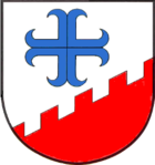
Blazon : "In silver a lowered, oblique-left red sloping crenellated wall, above it, offset slightly to the right from the center, a blue anchor cross."
Attractions
- The old, small church of the Holy Cross was demolished in 1742 and rebuilt in the same place and much larger, but is still one of the smaller churches in Dithmarschen. The altar dates from 1650. The crucifix found in 1495 , which presumably dates from the 12th century, is attached to a baroque wooden cross on the altar.
- There is a windmill in the village, the current version of which dates from 1863 and which was converted into a residential mill with dummy wings in 1978 .
- The grave of the successful writer of the Weimar Republic and later National Socialist Gustav Frenssen lies on the “Wodansberg” .
Sons and daughters of the church
- Hans Beeck (1896–1983), politician (NSDAP) and SS-Untersturmführer
Web links
Individual evidence
- ↑ North Statistics Office - Population of the municipalities in Schleswig-Holstein 4th quarter 2019 (XLSX file) (update based on the 2011 census) ( help on this ).
- ↑ a b Schleswig-Holstein topography. Vol. 10: Timmaspe - Ziethen . 1st edition Flying-Kiwi-Verl. Junge, Flensburg 2008, ISBN 978-3-926055-92-7 , p. 302 ( dnb.de [accessed on August 9, 2020]).
- ↑ State Statistical Office Schleswig-Holstein (Ed.): The population of the communities in Schleswig-Holstein 1867-1970 . State Statistical Office Schleswig-Holstein, Kiel 1972, p. 250 .
- ↑ Schleswig-Holstein's municipal coat of arms


