Barkenholm
| coat of arms | Germany map | |
|---|---|---|

|
Coordinates: 54 ° 14 ' N , 9 ° 10' E |
|
| Basic data | ||
| State : | Schleswig-Holstein | |
| Circle : | Dithmarschen | |
| Office : | Parish land parishes of Eider | |
| Height : | 9 m above sea level NHN | |
| Area : | 5.11 km 2 | |
| Residents: | 163 (Dec. 31, 2019) | |
| Population density : | 32 inhabitants per km 2 | |
| Postal code : | 25791 | |
| Area code : | 04836 | |
| License plate : | HEI, MED | |
| Community key : | 01 0 51 005 | |
| Office administration address: | Kirchspielsschreiber-Schmidt-Straße 1 25779 Hennstedt |
|
| Website : | ||
| Mayor : | Thorsten Eggers | |
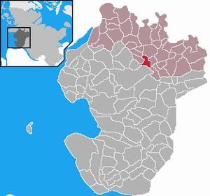
| Location of the municipality of Barkenholm in the Dithmarschen district | ||
Barkenholm is a municipality in the Dithmarschen district in Schleswig-Holstein and has no other districts.
geography
Deepest point
The lowest point in the municipality is 70 centimeters below, the highest 14 meters above sea level.
Neighboring communities
Neighboring communities are the communities of Linden , Tellingstedt (exclave Rederstall) and Gaushorn , the city of Heide and the communities of Süderheistedt and Norderheistedt (all in the district of Dithmarschen), starting clockwise in the north .
history
The community was first mentioned in writing as deme dorpe Birkenholm in a complaint by the Dithmarscher against the Schauenburg count Adolf VIII. During his last failed conquest he is said to have caused damage of 800 marks in the community.
The community was dominated by agriculture. In 1560 there were eight farmers growing rye , oats and buckwheat . A map from 1775 shows that only the Geest areas were cultivated; the large moor, forest and kink areas lay fallow. When the moors were reclaimed in the 19th century, a brick industry developed for a short time . From 1807 to the 1960s, Barkenholm housed a one-class elementary school .
On April 1, 1934, the parish state community Hennstedt was dissolved. All of their village communities, village communities and farmers became independent communities / rural communities, including Barkenholm.
Today four farmers still work in the community; Trade and industry have long since disappeared.
politics
Community representation
The last local election took place on May 26, 2013. Since the local elections in 2013, the WGB voter community has all seven seats in the local council.
coat of arms
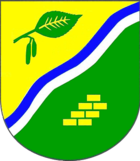
Description of the coat of arms : "Divided from gold and green by a blue and silver wave bar obliquely to the left, above a green obliquely left birch leaf with infructescence, below seven golden 1: 2: 2: 2 bricks."
Economy and Infrastructure
From 1905 to 1937 the place had a railway connection with the Norderdithmarschen district railway .
Web links
- Municipality of Barkenholm at the parish regional authorities of Eider
- Private website about Barkenholm
Individual evidence
- ↑ North Statistics Office - Population of the municipalities in Schleswig-Holstein 4th quarter 2019 (XLSX file) (update based on the 2011 census) ( help on this ).
- ↑ Aasbüttel - Bordesholm . In: Wolfgang Henze (ed.): Schleswig-Holstein topography: cities and villages of the country . 1st edition. tape 1 . Flying-Kiwi-Verl. Junge, Flensburg 2001, ISBN 3-926055-58-8 , p. 214 .
- ↑ State Statistical Office Schleswig-Holstein (ed.): The population of the communities in Schleswig-Holstein 1867 - 1970 . State Statistical Office Schleswig-Holstein, Kiel 1972, p. 251 .
- ↑ http://www.dithmarschen.de/media/custom/647_8130_1.HTML?1369896214 Result district election 2013
- ↑ Result of the 2013 local elections in the parish district authorities Eider ( page no longer available , search in web archives ) Info: The link was automatically marked as defective. Please check the link according to the instructions and then remove this notice.
- ↑ Schleswig-Holstein's municipal coat of arms


