Süderhastedt
| coat of arms | Germany map | |
|---|---|---|

|
Coordinates: 54 ° 3 ' N , 9 ° 13' E |
|
| Basic data | ||
| State : | Schleswig-Holstein | |
| Circle : | Dithmarschen | |
| Office : | Burg-Sankt Michaelisdonn | |
| Height : | 11 m above sea level NHN | |
| Area : | 15.74 km 2 | |
| Residents: | 755 (Dec. 31, 2019) | |
| Population density : | 48 inhabitants per km 2 | |
| Postal code : | 25727 | |
| Area code : | 04830 | |
| License plate : | HEI, MED | |
| Community key : | 01 0 51 110 | |
| LOCODE : | DE 68D | |
| Office administration address: | Holzmarkt 7 25712 Burg |
|
| Website : | ||
| Mayor : | Roland Ruesch ( CDU ) | |
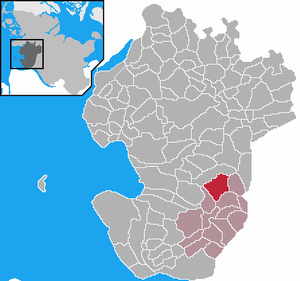
| Location of the municipality of Süderhastedt in the Dithmarschen district | ||
Süderhastedt is a municipality in the Dithmarschen district in Schleswig-Holstein . The place is on the Heide-Itzehoer Geest and there is a primary school. In addition to Süderhastedt, Neuhof, Kleinrade and Kleinhastedt are in the municipality.
history
In the Reichstag election in March 1933 in the parish of Süderhastedt, 77.7% voted for the NSDAP , 5.6% for the DNVP , 10.1% for the SPD and 4.8% for the KPD, with a turnout of 88.0%.
On December 1, 1934, the parish district of Süderhastedt was dissolved. All of their villages, village communities and farmers became independent communities / rural communities, including their main town, Süderhastedt.
Incorporations
On February 1, 1966, the community of Kleinhastedt was incorporated.
politics
Community representation
Of the eleven seats in the municipal council, the CDU has six seats and the KWV electoral community five seats since the local elections in 2018 .
coat of arms
Blazon : "In green over two crossed, upright silver swords, three silver (heraldic) roses placed on stakes with green lugs between two awned ears of corn."
The roses in the coat of arms approved in 1991 are depicted on the altar of St. Laurentius Church , one of the oldest in the district. The swords indicate the old meaning of the name Hastedt (fortification) and the ears of wheat emphasize the importance of agriculture for the place.
Attractions
The list of cultural monuments in Süderhastedt includes the cultural monuments entered in the list of monuments of Schleswig-Holstein.
Wind farm
When the rotor blades for a turbine were delivered to a nearby wind farm, 3 special transports had to interrupt their journey due to two traffic islands until they were dismantled.
Web links
Individual evidence
- ↑ North Statistics Office - Population of the municipalities in Schleswig-Holstein 4th quarter 2019 (XLSX file) (update based on the 2011 census) ( help on this ).
- ↑ Schleswig-Holstein topography. Vol. 9: Schönberg - Tielenhemme . 1st edition Flying-Kiwi-Verl. Junge, Flensburg 2007, ISBN 978-3-926055-91-0 , p. 288 ( dnb.de [accessed on August 6, 2020]).
- ↑ AKENS Information 39, Omland: "All of us 'yes' to the leader". Retrieved November 26, 2019 .
- ↑ State Statistical Office Schleswig-Holstein (ed.): The population of the communities in Schleswig-Holstein 1867 - 1970 . State Statistical Office Schleswig-Holstein, Kiel 1972, p. 250 .
- ↑ State Statistical Office Schleswig-Holstein (Ed.): The population of the communities in Schleswig-Holstein 1867-1970 . State Statistical Office Schleswig-Holstein, Kiel 1972, p. 53 .
- ↑ Community representative of the community of Süderhastedt (PDF; 30 kB)
- ↑ Schleswig-Holstein's municipal coat of arms
- ↑ ndr.de: Heavy transport planned: Three trucks are stuck. NDR.de, September 23, 2014


