Hemmingstedt
| coat of arms | Germany map | |
|---|---|---|

|
Coordinates: 54 ° 9 ' N , 9 ° 4' E |
|
| Basic data | ||
| State : | Schleswig-Holstein | |
| Circle : | Dithmarschen | |
| Office : | Parish Landgemeinde Heider Umland | |
| Height : | 10 m above sea level NHN | |
| Area : | 16.01 km 2 | |
| Residents: | 2878 (Dec. 31, 2019) | |
| Population density : | 180 inhabitants per km 2 | |
| Postal code : | 25770 | |
| Area code : | 0481 | |
| License plate : | HEI, MED | |
| Community key : | 01 0 51 048 | |
| LOCODE : | DE HMD | |
| Office administration address: | Kirchspielsweg 6 25746 Heide |
|
| Website : | ||
| Mayor : | Hartmut Busdorf (WGH) | |
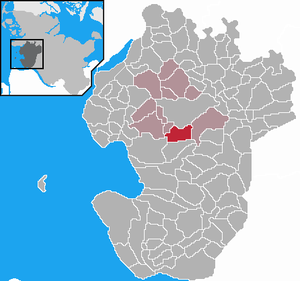
| Location of the municipality of Hemmingstedt in the Dithmarschen district | ||
Hemmingstedt is a municipality in the Dithmarschen district in Schleswig-Holstein .
geography
location
Hemmingstedt is located in the center of the Dithmarschen district between the cities of Heide and Meldorf on federal road 5 . The North Sea can be reached by car in 20 minutes. The Heide-Süd / Hemmingstedt motorway access to federal motorway 23 in the direction of Hamburg is nearby . Hemmingstedt is on the Marschbahn and has a depot here .
Community structure
In addition to Hemmingstedt, the localities of Braaken, Dellweg, Hohenheide, Norderwurth, Schwienmoor and Volkerswurth are in the municipality.
Neighboring communities
Neighboring communities are the city of Heide and the communities of Nordhastedt , Epenwöhrden , Nordermeldorf , Wöhrden , Lieth and Lohe-Rickelshof (all in the Dithmarschen district), starting clockwise to the north .
history
The parish of Hemmingstedt was first mentioned in 1323. In the Battle of Hemmingstedt on February 17, 1500, Dithmarscher farmers, led by Wulf Isebrand, defeated the Danish army under Johann , King of Denmark, Norway and Sweden , and his brother Friedrich , Duke of Schleswig and Holstein . In numbers they were inferior. However, they opened the sluice , flooded the land and used their spits to jump logs . As a result, they were able to repeatedly attack the barely mobile army and ultimately achieve victory.
On April 1, 1934, the parish Hemmingstedt was dissolved. All of their village communities, village communities and farmers became independent communities / rural communities, including their main town, Hemmingstedt.
Incorporations
On January 1, 1966, the previously independent municipality of Braaken was incorporated. This belonged to the parish of Hemmingstedt until 1934.
Cultural monuments
Buildings
In the community there is a church from the Renaissance period and a large windmill from 1858. The Marienkirche was built in the 14th century with field and goat stones. The figure of the crucified Jesus Christ dates from the 15th century. The oldest surviving Protestant pulpit in the region and the altar with Mannerist style elements date from 1560. The church is adorned with numerous family coats of arms from 1578/79.
In Hemmingstedt there is also one of the highest structures on the west coast , the 175 meter chimney of the Hemmingstedt refinery .
politics
Community representation
Of the 17 seats in the municipal council has Wählergemeinschaft WGH since the municipal election in 2013 seven seats, the CDU four and the SPD and the voter community FWH each have three seats.
coat of arms
Blazon : “Lowered divided. Above in silver, growing and diagonally crossed, a broken black lance carrying the Holstein nettle leaf flag and a black halberd, below in red a golden fire. "
economy
There is an oil refinery in Hemmingstedt . The Heide refinery is one of the largest employers in the district and the reason why bombing raids were carried out on Hemmingstedt as one of the few Dithmarsch communities in World War II, with corresponding effects on the cityscape. The refinery, which was formerly owned by DEA , Shell and has been owned by US investor A. Gary Klesch since 2010 , processes around four million tons of crude oil a year. This produces, among other things, diesel fuel , light heating oil , aviation turbine fuel and basic materials for the chemical industry ( ethylene , benzene , ethylbenzene ). This is sung by the band Turbostaat in the song "Hemmingstedt".
If the oil originally came from the oil field between Hemmingstedt and Heide, imported oil was added later via the port of Brunsbüttel . In 1991 the field near Hemmingstedt dried up, but now about a third of the raw material comes from the Mittelplate oil field in the nearby mudflats .
traffic
The Hemmingstedt station is located on the Marschbahn and serves as a depot .
Personalities
- Hermann Pook (1901–1983), SS-Obersturmbannführer and, as chief dentist, superior of the dentists in concentration camps , practiced as a resident dentist in Hemmingstedt after the end of the war
- Holger Christiansen (* 1957), doctor and university professor
Web links
Individual evidence
- ↑ North Statistics Office - Population of the municipalities in Schleswig-Holstein 4th quarter 2019 (XLSX file) (update based on the 2011 census) ( help on this ).
- ↑ State Statistical Office Schleswig-Holstein (Ed.): The population of the communities in Schleswig-Holstein 1867-1970 . State Statistical Office Schleswig-Holstein, Kiel 1972, p. 250 .
- ↑ State Statistical Office Schleswig-Holstein (ed.): The population of the communities in Schleswig-Holstein 1867 - 1970 . State Statistical Office Schleswig-Holstein, Kiel 1972, p. 46 .
- ↑ Announcement of the municipal election results in the municipality of Hemmingstedt ( Memento of the original from April 2, 2015 in the Internet Archive ) Info: The archive link was inserted automatically and has not yet been checked. Please check the original and archive link according to the instructions and then remove this notice. . amt-heider-umland.de, accessed on 7 Aug 2013 (PDF, 248 kB).
- ↑ http://efi2.schleswig-holstein.de/wr/wr.asp?Aktion=Datenblatt&ID=568 Municipal coat of arms of Schleswig-Holstein


