Place-Wittenwurth
| coat of arms | Germany map | |
|---|---|---|

|
Coordinates: 54 ° 16 ' N , 9 ° 4' E |
|
| Basic data | ||
| State : | Schleswig-Holstein | |
| Circle : | Dithmarschen | |
| Office : | Parish Landgemeinde Heider Umland | |
| Height : | 1 m above sea level NHN | |
| Area : | 10.71 km 2 | |
| Residents: | 413 (Dec. 31, 2019) | |
| Population density : | 39 inhabitants per km 2 | |
| Postal code : | 25795 | |
| Area code : | 04837 | |
| License plate : | HEI, MED | |
| Community key : | 01 0 51 107 | |
| Office administration address: | Kirchspielsweg 6 25746 Heide |
|
| Website : | ||
| Mayor : | Michael Borchardt (ABBSW) | |
| Location of the community of Stelle-Wittenwurth in the district of Dithmarschen | ||
Stelle-Wittenwurth is a municipality in the Dithmarschen district in Schleswig-Holstein .
geography
Stelle is on a small Geest island, barely ten meters high, between the Weddingstedter Geest and the sand dune that extends between Wittenwurth and Dahrenwurth.
history
According to urn finds, there must have been a settlement at Stelle as early as the Stone Age. The village of Stelle appears in the inventory of the Neumünster-Bordesholm Monastery around 1200 (source: Dr. Walter Kühl “Traditions about the village of Stelle”). It is difficult to say where the name Stelle-Wittenwurth comes from. Around 1222, the places Stelle and Wittenwurth were traced back to the names Sybern de Stella and Boge and Ove Wittenstad. In 1329 the place was mentioned as Stella (according to the village chronicle 1559–1959 from: Dithmarscher Landeskunde 9th year, p. 8).
The peasantry point-Wittenwurth is one of the oldest in the country. The Stellerburg , which is located in Weddingstedter municipality, is a Saxon ring wall system , which dates from the time before Charlemagne and served at the strategically favorable point for defense against the Vikings . It was abandoned in the 10th century. It was first popularized in 1562. Today there are only three farms left in the village. Stelle-Wittenwurth is on the Hamburg-Westerland railway line . Until the early 1980s there was a stop in Wittenwurth.
On April 1, 1934 the parish of Weddingstedt was dissolved. All of their villages, village communities and farmers became independent communities / rural communities, including Stelle-Wittenwurth.
politics
Community representation
Of the nine seats in the municipal council, the ABBSW community of voters has four seats since the 2013 local elections, the AGWSt-W community has three and the UWSt-W community has two seats.
coat of arms
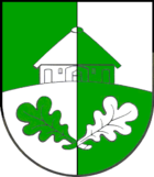
Blazon : “Square of green and silver with a curved dividing line; in interchanged colors covered above with a farmhouse (frontal view), below with two outward-facing, upright oak leaves that cross on the stems. "
The community lies on the edge of the Schleswig-Holstein marshland on the back of a chain of dunes, which, as the former shore zone of the North Sea, extends into southwestern Schleswig-Holstein. On this "white, sandy Wurth", the first settlers built their first dwellings, protected from the floods of the North Sea, which, like the surrounding marshland reclaimed from the sea, were shaped by agriculture over the centuries. The vertical division of the coat of arms with the double color change between silver and green symbolizes the geologically significant situation between the sea and the mainland. A gable-independent farmhouse typical of this region on a slight hill (Wurth) refers to the place name Wittenwurth. The crossed oak leaves indicate that there used to be extensive mixed oak forests on the edge of the marsh .
Personalities
- Bärbel Wolfmeier (* 1966), radio presenter and Low German author
Web links
Individual evidence
- ↑ North Statistics Office - Population of the municipalities in Schleswig-Holstein 4th quarter 2019 (XLSX file) (update based on the 2011 census) ( help on this ).
- ↑ State Statistical Office Schleswig-Holstein (Ed.): The population of the communities in Schleswig-Holstein 1867-1970 . State Statistical Office Schleswig-Holstein, Kiel 1972, p. 251 .
- ↑ Schleswig-Holstein's municipal coat of arms


