Tielenhemme
| coat of arms | Germany map | |
|---|---|---|

|
Coordinates: 54 ° 16 ' N , 9 ° 23' E |
|
| Basic data | ||
| State : | Schleswig-Holstein | |
| Circle : | Dithmarschen | |
| Office : | Parish land parishes of Eider | |
| Height : | 0 m above sea level NHN | |
| Area : | 12.71 km 2 | |
| Residents: | 161 (Dec. 31, 2019) | |
| Population density : | 13 inhabitants per km 2 | |
| Postal code : | 25794 | |
| Area code : | 04803 | |
| License plate : | HEI, MED | |
| Community key : | 01 0 51 117 | |
| Office administration address: | Kirchspielsschreiber-Schmidt-Straße 1 25779 Hennstedt |
|
| Website : | ||
| Mayor : | Hans-Hermann de Freese (WGT) | |
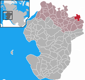
| Location of the municipality of Tielenhemme in the Dithmarschen district | ||
Tielenhemme is a municipality in the Dithmarschen district in Schleswig-Holstein .
geography
Tielenhemme is located directly on the Eider and Tielenau rivers . The community consists of the three districts Schüttingdeich, Eiderdeich and Königsfähre as well as four streets, two of which are holiday home areas. Tileburg is also in the municipality.
The nature reserve Dellstedter Birkwildmoor is located near the community .
Until December 12, 1960, a public ferry, the Hohner ferry , drove over the Eider. Since the closure, the passenger ferry has now been operated by a ferry association.
history
The community originally emerged from the three former Eider Islands Sehebrook , Hulpeshemme and Tielenhemme . For a long time these were a point of contention between Dithmarschen and the Stapelholm landscape . At the northern tip of Tielenhemmes there was a castle of the dukes of the Duchy of Schleswig , which was directed against the Dithmarschers. The administrative seat of the Stapelholm landscape was also located here until 1500. After the victory in the Battle of Hemmingstedt , the castle and the three islands fell to the Dithmarschern. In 1623 the islands were combined to form Tielenhemmer Koog and connected to the Dithmarscher land area.
Two schools were built in Tielenhemme, in the district of Schüttingdeich in 1892 and on the Eiderdeich in 1896. In 1972 the schools could not be prevented from closing.
On April 1, 1934, the parish Tellingstedt was dissolved. All of their village communities, village communities and farmers became independent communities / rural communities, including Tielenhemme.
politics
Since the local elections in 2013, the WGT voter community has all seven seats in the local council.
Personalities
- Anne-Marga Sprick (* 1934), Low German author
- Sarah Kirsch (1935–2013), writer; lived in Tielenhemme since 1983. The urn with her ashes was buried in the garden of her house.
literature
- Klaus Timm and Erwin Willenbrecht (eds.): Tielenhemme. History of a village on the Eider . On behalf of the municipality of Tielenhemme. Norderstedt 2010, ISBN 978-3-8391-7535-4 .
Web links
Individual evidence
- ↑ North Statistics Office - Population of the municipalities in Schleswig-Holstein 4th quarter 2019 (XLSX file) (update based on the 2011 census) ( help on this ).
- ↑ Schleswig-Holstein topography. Vol. 9: Schönberg - Tielenhemme . 1st edition Flying-Kiwi-Verl. Junge, Flensburg 2007, ISBN 978-3-926055-91-0 , p. 382 ( dnb.de [accessed on August 6, 2020]).
- ↑ Peter W. Dirks u. Rolf Kööp: 750 years of the Stapelholm landscape. 2010, p. 31
- ↑ State Statistical Office Schleswig-Holstein (Ed.): The population of the communities in Schleswig-Holstein 1867-1970 . State Statistical Office Schleswig-Holstein, Kiel 1972, p. 251 .
- ↑ Final result of the local elections 2013 ( page no longer available , search in web archives ) Info: The link was automatically marked as defective. Please check the link according to the instructions and then remove this notice.


