Wrohm
| coat of arms | Germany map | |
|---|---|---|

|
Coordinates: 54 ° 13 ' N , 9 ° 23' E |
|
| Basic data | ||
| State : | Schleswig-Holstein | |
| Circle : | Dithmarschen | |
| Office : | Parish land parishes of Eider | |
| Height : | 27 m above sea level NHN | |
| Area : | 11.45 km 2 | |
| Residents: | 706 (Dec. 31, 2019) | |
| Population density : | 62 inhabitants per km 2 | |
| Postal code : | 25799 | |
| Area code : | 04802 | |
| License plate : | HEI, MED | |
| Community key : | 01 0 51 136 | |
| Office administration address: | Kirchspielsschreiber- Schmidt-Strasse 1 25779 Hennstedt |
|
| Website : | ||
| Mayor : | Jens Lahrsen (WGW) | |
| Location of the municipality of Wrohm in the Dithmarschen district | ||
Wrohm is a municipality in the Dithmarschen district in Schleswig-Holstein .
geography
location
The community is located on the federal highway 203 about halfway between Heide and Rendsburg in an Eiderbogen on the eastern border of Dithmarschen.
Neighboring communities
Neighboring communities are the communities Dellstedt ( Dithmarschen district ), Hamdorf and Prinzenmoor (both in the Rendsburg-Eckernförde district ) and Osterrade and Süderdorf (both in turn in the Dithmarschen district ), starting clockwise in the north .
Community structure
The community consists of the districts Altenfähre, Lexfähre , Neuenfähre and Wrohm.
history
Wrohm is located on the Dithmarscher Geestrücken, which is old moraine and was created more than 100,000 years ago by glacier deposits during the penultimate ice age. The first settlements occurred during the Younger Stone Age , as is proven by finds of flint axes in the eastern field of Wrohm. In 1905 workers came across an urn cemetery from the Iron Age and in 1988 potsherds and a well-preserved clay pot were discovered; the finds were dated to 500 BC. Dated.
Wrohm was first mentioned in a document in 1447 in a complaint by the Dithmarscher against an attack by the Holsteiners. The name Wrohm should be traced back to the location of the village: "place in the bay" or "place in the corner". The village belonged to the parish of Tellingstedt .
On April 1, 1934, the parish Tellingstedt was dissolved. All of their village communities, village communities and farmers became independent communities / rural communities, including Wrohm.
politics
Community representation
Since the municipal elections in 2013, the WGW electoral community has all nine seats in the municipal council.
coat of arms
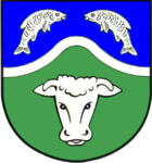
Blazon : “Divided by a silver bar bent up in the middle of blue and green. Above two silver fish jumping towards each other, below a silver ox head. "
Economy and Infrastructure
From 1905 to 1937 the place had a railway connection with the Norderdithmarschen district railway .
In 2001, a new combined rescue and fire station was built by the Dithmarschen district in order to reduce the arrival times of the ambulance (RTW) in the rural villages in the east of Dithmarschen .
There is a Protestant kindergarten in the community.
Personalities
Sons and daughters of the church
- Hartich Sierk (1588– after 1664), farmer and chronicler
- Greten Handorf , b. Rohwer (1880–1944), shipowner in Cuxhaven , the only female shipowner in Germany at the time
- Hermann Glüsing (1908–1981), politician ( CDU ), Member of the Bundestag , district administrator in the former Norderdithmarschen district
literature
- Chronicle of the community of Wrohm . Published by the municipality of Wrohm. Husum 1995.
Web links
Individual evidence
- ↑ North Statistics Office - Population of the municipalities in Schleswig-Holstein 4th quarter 2019 (XLSX file) (update based on the 2011 census) ( help on this ).
- ↑ Schleswig-Holstein topography. Vol. 10: Timmaspe - Ziethen . 1st edition Flying-Kiwi-Verl. Junge, Flensburg 2008, ISBN 978-3-926055-92-7 , p. 380 ( dnb.de [accessed on August 9, 2020]).
- ↑ State Statistical Office Schleswig-Holstein (Ed.): The population of the communities in Schleswig-Holstein 1867-1970 . State Statistical Office Schleswig-Holstein, Kiel 1972, p. 251 .
- ↑ Final result of the local elections 2013 ( page no longer available , search in web archives ) Info: The link was automatically marked as defective. Please check the link according to the instructions and then remove this notice.
- ↑ Schleswig-Holstein's municipal coat of arms


