
Oldenbüttel
| coat of arms | Germany map | |
|---|---|---|

|
Coordinates: 54 ° 10 ′ N , 9 ° 27 ′ E |
|
| Basic data | ||
| State : | Schleswig-Holstein | |
| Circle : | Rendsburg-Eckernförde | |
| Office : | Mittelholstein | |
| Height : | 3 m above sea level NHN | |
| Area : | 7.97 km 2 | |
| Residents: | 245 (Dec. 31, 2019) | |
| Population density : | 31 inhabitants per km 2 | |
| Postcodes : | 25557, 24797 | |
| Primaries : | 04872, 04332 | |
| License plate : | RD, ECK | |
| Community key : | 01 0 58 119 | |
| LOCODE : | DE OLB | |
| Office administration address: | Am Markt 15 24594 Hohenwestedt |
|
| Website : | ||
| Mayor : | Carsten Ohlrogge (KWG) | |
| Location of the municipality of Oldenbüttel in the Rendsburg-Eckernförde district | ||
 |
||

Oldenbüttel is a municipality in the Rendsburg-Eckernförde district in Schleswig-Holstein . Bokelhoop and Bokhorst are in the municipality.
Geography and traffic
Oldenbüttel is about 20 km east of Heide on both sides of the Kiel Canal , the town center is on the south bank. The federal highway 23 runs from Hamburg to Heide about 15 km to the west .
The Gieselau Canal , which was built in 1937 as a connection between the Kiel Canal and the Eider , runs in the northern part of the municipality .
history
In terms of settlement history, Oldenbüttel is one of the Büttel localities.
politics
Community representation
The KWG electoral community has had all nine seats in the municipal council since the 2013 local elections.
coat of arms
Blazon : "Divided by blue and green by two silver wavy bars, slightly lowered, above a silver-black chain ferry, below three silver houses 2: 1."
The three houses symbolize the three districts of Bokelhoop, Bokhorst and Oldenbüttel.
photos

Painted transformer building
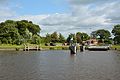
Oldenbüttel ferry terminal
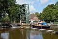
Lock on the Gieselau Canal

Fishing spot for disabled citizens


Personalities
- Kirsten Krüger (* 1955 in Oldenbüttel), multiple German champion in table tennis
Web links
Individual evidence
- ↑ North Statistics Office - Population of the municipalities in Schleswig-Holstein 4th quarter 2019 (XLSX file) (update based on the 2011 census) ( help on this ).
- ↑ Schleswig-Holstein topography. Vol. 7: Munkbrarup - Pohnsdorf . 1st edition Flying-Kiwi-Verl. Junge, Flensburg 2006, ISBN 978-3-926055-88-0 , p. 248 ( dnb.de [accessed on July 22, 2020]).
- ↑ Allocation of seats after the 2013 municipal elections ( memento of the original from March 8, 2016 in the Internet Archive ) Info: The archive link was inserted automatically and has not yet been checked. Please check the original and archive link according to the instructions and then remove this notice.
- ↑ Schleswig-Holstein's municipal coat of arms
Backguard | Ahlefeld-Bistensee | Alt Duvenstedt | Altenhof | Altenholz | Arpsdorf | Cinderella | Aukrug | Bargstall | Bargstedt | Barkelsby | Beldorf | Bendorf | Beringstedt | Bite | Blumenthal | Böhnhusen | Bokel | Bordesholm | Borgdorf-Seedorf | Borgstedt | Bornholt | Bovenau | Brammer | Bredenbek | Pulpwood | Brekendorf | Brinjahe | Brodersby | Bruges | Büdelsdorf | Bünsdorf | Christiansholm | Damendorf | Damp | Dänischenhagen | Dätgen | Dörphof | Eckernförde | Ehndorf | Eisendorf | Ellerdorf | Elsdorf-Westermühlen | Embühren | Emkendorf | Field | Felm | Fleckeby | Flintbek | Fockbek | Friedrichsgraben | Friedrichsholm | Gammelby | Gettorf | Gnutz | Gokels | Goosefeld | Grauel | Grevenkrug | Groß Buchwald | Groß Vollstedt | Groß Wittensee | Güby | Haale | Haby | Hamdorf | Hamweddel | Hanerau-Hademarschen | Hassmoor | Heinkenborstel | Hofeld | Hohenwestedt | Scorn | Holtsee | Holzbunge | Holzdorf | Hearst | Hummelfeld | Huts | Year village | Jevenstedt | Karby | Klein Wittensee | King's Hill | Kosel | Crogaspe | Kronshagen | Curvilinear | Long tail | Lindau | Lohe-Föhrden | Loop | Loose | Luhnstedt | Lütjenwestedt | Meezen | Melsdorf | Mielkendorf | Molfsee | Mörel | Mühbrook | Negenharry | Neudorf-Bornstein | New Duvenstedt | Neuwittenbek | Nienborstel | Nindorf | Noer | Nortorf | Nübbel | Oldenbüttel | Oldenhütten | Osdorf | Ostenfeld (Rendsburg) | Osterby | Osterrönfeld | Osterstedt | Ottendorf | Owschlag | Padenstedt | Prince's Moor | Quarnbek | Rade b. Hohenwestedt | Rade b. Rendsburg | Reesdorf | Remmels | Rendsburg | Rickert | Rieseby | Rodenbek | Rumohr | Schacht-Audorf | Schierensee | Schinkel | Schmalstede | Schönbek | Schönhorst | Schülldorf | Schülp b. Nortorf | Schülp b. Rendsburg | Schwedeneck | Seefeld | Sehestedt | Sophienhamm | Sören | Stafstedt | Steenfeld | Beaches | Tackesdorf | Tappendorf | Techelsdorf | Thaden | Thumby | Timmaspe | Todenbüttel | Tüttendorf | Waabs | Wapelfeld | Warder | Wasbek | Wattenbek | Westensee | Westerrönfeld | Windeby | Winnemark