
Mühbrook
| coat of arms | Germany map | |
|---|---|---|

|
Coordinates: 54 ° 9 ' N , 10 ° 1' E |
|
| Basic data | ||
| State : | Schleswig-Holstein | |
| Circle : | Rendsburg-Eckernförde | |
| Office : | Bordesholm | |
| Height : | 28 m above sea level NHN | |
| Area : | 5.3 km 2 | |
| Residents: | 563 (Dec. 31, 2019) | |
| Population density : | 106 inhabitants per km 2 | |
| Postal code : | 24582 | |
| Area code : | 04322 | |
| License plate : | RD, ECK | |
| Community key : | 01 0 58 108 | |
| Office administration address: | Mühlenstrasse 7 24582 Bordesholm |
|
| Website : | ||
| Mayor : | Wulf Klüver (KWG) | |
| Location of the municipality of Mühbrook in the Rendsburg-Eckernförde district | ||
 |
||

Mühbrook is a municipality on Einfelder See and Dosenmoor in the district of Rendsburg-Eckernförde in Schleswig-Holstein . The hamlet of Hohenhorst is located on the 5.3 square kilometer municipal area, which extends to the Bordesholmer See in the north . To the north of the Tökshorst industrial park is the small lake Mühbrooker Meer . A cycling and hiking trail has been developed around the Einfelder See.
history
The village of Muthebroge was mentioned in 1238 when Adolf IV (Schauenburg and Holstein) awarded the tithes to the Neumünster monastery .
coat of arms
Blazon : “Divided into a wavy cut of silver and blue. Above the red gable of a Bordesholm farmhouse between two green oak leaves, below a two-wheeled silver cart placed at a corner with the drawbar pointing forward. "
economy
Mühbrook has changed significantly from an agricultural place due to its proximity to Neumünster , living and commercial are predominant in Mühbrook today. Therefore the place was proposed in 1998 for a village development plan. The Tökshorst industrial park was set up on the basis of this plan.
Recreation
As part of the concept of “gentle tourism and local recreation”, the Mühbrook Bay of the Einfelder See was redesigned and the eco-culture path “the Einfelder Sehpunkte” was created around the lake. Furthermore, a leisure area was set up at the former village school.
photos

Fire station
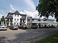
Hotel Seeschlösschen
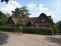
Mayor's House
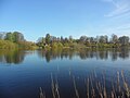
Mühbrook and the Mühbrooker Bay seen from the Einfelder See


Web links
Individual evidence
- ↑ North Statistics Office - Population of the municipalities in Schleswig-Holstein 4th quarter 2019 (XLSX file) (update based on the 2011 census) ( help on this ).
- ↑ Schleswig-Holstein topography. Vol. 6: Kronprinzenkoog - Mühlenrade . 1st edition Flying-Kiwi-Verl. Junge, Flensburg 2006, ISBN 978-3-926055-85-9 , pp. 352 ( dnb.de [accessed on July 29, 2020]).
- ↑ Schleswig-Holstein's municipal coat of arms
Backguard | Ahlefeld-Bistensee | Alt Duvenstedt | Altenhof | Altenholz | Arpsdorf | Cinderella | Aukrug | Bargstall | Bargstedt | Barkelsby | Beldorf | Bendorf | Beringstedt | Bite | Blumenthal | Böhnhusen | Bokel | Bordesholm | Borgdorf-Seedorf | Borgstedt | Bornholt | Bovenau | Brammer | Bredenbek | Pulpwood | Brekendorf | Brinjahe | Brodersby | Bruges | Büdelsdorf | Bünsdorf | Christiansholm | Damendorf | Damp | Dänischenhagen | Dätgen | Dörphof | Eckernförde | Ehndorf | Eisendorf | Ellerdorf | Elsdorf-Westermühlen | Embühren | Emkendorf | Field | Felm | Fleckeby | Flintbek | Fockbek | Friedrichsgraben | Friedrichsholm | Gammelby | Gettorf | Gnutz | Gokels | Goosefeld | Grauel | Grevenkrug | Groß Buchwald | Groß Vollstedt | Groß Wittensee | Güby | Haale | Haby | Hamdorf | Hamweddel | Hanerau-Hademarschen | Hassmoor | Heinkenborstel | Hofeld | Hohenwestedt | Scorn | Holtsee | Holzbunge | Holzdorf | Hearst | Hummelfeld | Huts | Year village | Jevenstedt | Karby | Klein Wittensee | King's Hill | Kosel | Crogaspe | Kronshagen | Curvilinear | Long tail | Lindau | Lohe-Föhrden | Loop | Loose | Luhnstedt | Lütjenwestedt | Meezen | Melsdorf | Mielkendorf | Molfsee | Mörel | Mühbrook | Negenharry | Neudorf-Bornstein | New Duvenstedt | Neuwittenbek | Nienborstel | Nindorf | Noer | Nortorf | Nübbel | Oldenbüttel | Oldenhütten | Osdorf | Ostenfeld (Rendsburg) | Osterby | Osterrönfeld | Osterstedt | Ottendorf | Owschlag | Padenstedt | Prince's Moor | Quarnbek | Rade b. Hohenwestedt | Rade b. Rendsburg | Reesdorf | Remmels | Rendsburg | Rickert | Rieseby | Rodenbek | Rumohr | Schacht-Audorf | Schierensee | Schinkel | Schmalstede | Schönbek | Schönhorst | Schülldorf | Schülp b. Nortorf | Schülp b. Rendsburg | Schwedeneck | Seefeld | Sehestedt | Sophienhamm | Sören | Stafstedt | Steenfeld | Beaches | Tackesdorf | Tappendorf | Techelsdorf | Thaden | Thumby | Timmaspe | Todenbüttel | Tüttendorf | Waabs | Wapelfeld | Warder | Wasbek | Wattenbek | Westensee | Westerrönfeld | Windeby | Winnemark